I have mineral rights in Section 204 and Section 163 in Fisher County.
Does anyone know if any drilling is going on in these sections?
I have mineral rights in Section 204 and Section 163 in Fisher County.
Does anyone know if any drilling is going on in these sections?
Hello Jean,
I tried pulling up the General Land Office Map to view your area and I received this message:
NOTICE: GLO GIS Services will be unavailable from Thursday July 3 at 8:00 a.m. until Monday July 7 at 8:00 a.m. CST *
Also Jean I need the Block # and the Abstract # if possible to check your minerals area.
Clint Liles
Any drilling around H&TC Block 2 Section 69 or 70?
The only thing I have handy is the tract drawing and it shows. The South Half of Section 204.
And the North East Quarter, the South West quarter, and the South East Quarter of Section 163.
Clint Liles said:
Hello Jean,
I tried pulling up the General Land Office Map to view your area and I received this message:
NOTICE: GLO GIS Services will be unavailable from Thursday July 3 at 8:00 a.m. until Monday July 7 at 8:00 a.m. CST *
Also Jean I need the Block # and the Abstract # if possible to check your minerals area.
Clint Liles
Thanks Jean,
The Railroad Commission is updating some of their websites and the website is down till Monday morning
I’ll try that Monday morning sometime after 8 A M and go from there.
Hope you’re having a great weekend.
Clint Liles
I appreciate any thing you can find out.
Clint Liles said:
Thanks Jean,
The Railroad Commission is updating some of their websites and the website is down till Monday morning.
I’ll try that Monday morning sometime after 8 A M and go from there.
Hope you’re having a great weekend.
Clint Liles
Good morning Jean,
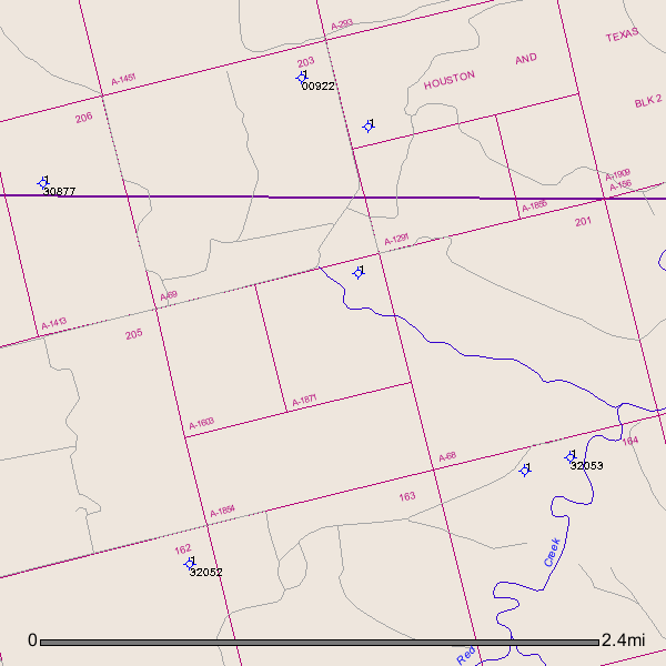
When I tried pulling up Sec. 204 on the GIS map I got several Sec. 204 but I have narrowed it down to Block 2/Sec.204/A-1854(South half of Sec. 204):
GIS Map of Fisher County A-1854/Sec. 204/Blk. 2:
I see no recent activity in the area. I see several dry holes that were drilled in the past (blue circles with sticks running through them) and 1 plugged oil well (green circle with green stick).
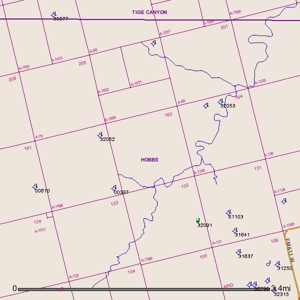
And next door to the South is A-138/Sec. 163/Blk 2:
Thank you for your help, The map is most appreciated. Makes things a little clearer.
Have a good day.
Clint Liles said:
Good morning Jean,
When I tried pulling up Section 204 on the GIS map I got several Section 204 but I have narrowed it down to Block 2/Section 204/Abstract 1854 (South half of Section 204):
GIS Map of Fisher County Abstract 1854/Section 204/Block 2:
I see no recent activity in the area. I see several dry holes that were drilled in the past (blue circles with sticks running through them) and 1 plugged oil well (green circle with green stick).
And next door to the South is Abstract 138/Section 163/Block 2:
Clint Liles