Let me start by saying I’m very new to this process, my brother & I inherited my mother’s mineral royalties a year ago. My question is regarding decimal percentage of my mineral interest. I currently receive royalties on one (1) well, 6 more wells have been drilled and are in production since May 2022, it’s been a long process but the title work is complete and DO’s will be sent out in the next week or so according to Laredo Petroleum, who is leasing the land. I was able to get some info from them prior to DO and they state that my decimal interest will be less in regards to these new wells. Does this seem correct? Why wouldn’t it be the same as my current interest? Maybe there is an obvious answer and if someone could shed light on my situation that would be great. I’m nervous to sign anything until I get some clarification. Thank you!!
The decimal interest depends upon the net acres, the royalty and the spaced acres and what perforations are assigned. If you have a larger spacing on these wells than the first one, then the net acres are divided by a larger denominator. Also, the first well could have had more perforations allocated to it and the other wells have less perforations in your acreage. Very common for subsequent wells to be different.
Thank you so much for the clarification, your knowledge in these matters is much appreciated!
If you post your abstract location, one of the Texas folks may be able to show you a map view of the wells so you can see the difference.
Someone did but I didn’t fully understand how the DO’s were figured out… (still don’t fully understand… lol) Listed our lease: All of W/2 Section 41 Block 3, Township 1 North, T&P Ry. Co. Survey.
Existing well name is Leech 32-44.
The bottom line IMO is you should be able to figure out exactly what your decimal is. In every well. Assuming you know what you own and take a look at the permit and/or DO.
The concept can seem daunting/complicated, but it’s not. You own 2% of this slice of pie, there are 8 slices of pie total, so you own 0.25% of the total pie.
Oftentimes in Midland Basin (Howard) you are getting paid for an old vertical Wolfberry well dedicated to 160 acres and then the operator goes and drills horizontal wells that are dedicated to 640 acres (that 160 acres plus 480 acres in which you own nothing), etc. So you end up with a quarter of the NRI in the new wells. As an example.
It is daunting. Can I trust the number they came up with? I’m trying to find the document that shows what % I own. I know the mineral acre—is that what you mean?
You can probably trust the number they came up with, but it’s better to have an independent idea of what that number should be.
The existing well appears to be the Leech 32-41 Unit A 1LS, which is a two-mile well drilled in the W2 of Section 32 and 41. The blue line on the map below. You own X% of that. The yellow lines are the new Leech 32-44 allocation wells. Assuming that you only own in the W2 of Section 41, then you should really only own an interest in the western 3 of those (2SB, 3SA, 4SB), as the others do not intersect your lease.
And that interest should roughly be 2/3 of X if X is your interest in the existing well, since they now include the W2 of Section 44 in which you own nothing. We are assuming that all of those wells were drilled as planned with roughly equal lateral lengths in Sections 32, 41, and 44. If they are crediting you with an interest in all 6 of the new wells, then you own something in the E2 of one of those sections or they are doing something wacky IMO.
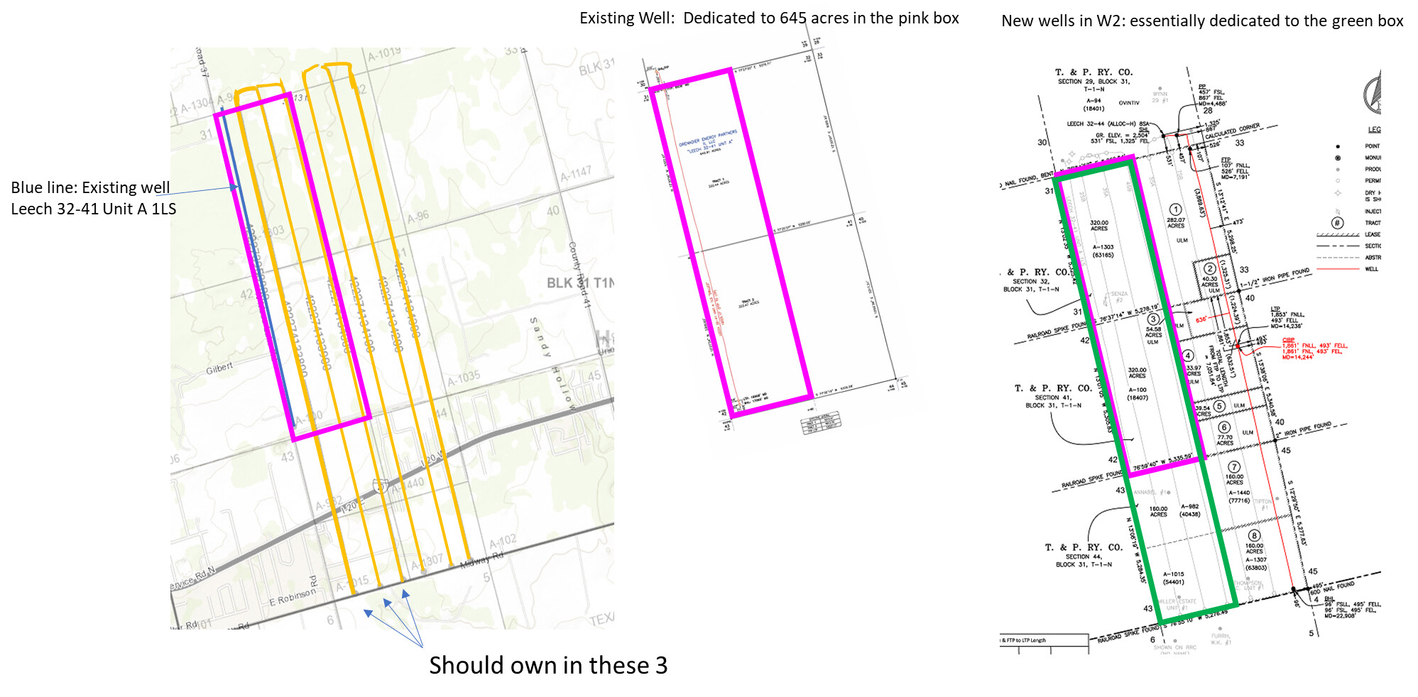
Ok thank you, this is new information… even if all the new wells have the same name, Leech 32-44? We assumed they all are part of our property, I will definitely be looking into this, thank you for the graphics!
I think they are all called Leech because the Leech lease is 640 acres in Section 32 (i.e. all of the section) so all of these wells go through that lease. They don’t all go through your lease. They are allocation wells. So you should only have interest in the ones that have perforated lateral in your tract (i.e. the ones in the W2).
I could be wrong. It sounded like you are getting Division Orders in the near future, take a look at those and see. Decimal definitely won’t be the same as the old well, it’s shorter therefore more of it is in your tract than will be for these longer wells.
Thank you! I really appreciated the forum for this reason, helping make clear a confusing situation! (At least confusing to me!) But I’m definitely learning a lot in the process.
Curious the first couple month’s production on those six wells. I’ve read where they were essentially water wells. I believe Laredo stock took a hit on that news. I think…Anyone with insight in monthly BBBL initial production across the 6 Leeches?
On Mineral IQ it appears to be gas and oil production but I’m no expert. Division orders and payout on 3 wells on the west half will come this week…
Just got my first royalty check for 3 of the Leech wells, definitely not water…
I assume the deal is that these are on the margin of the basin and therefore make more water and less oil. At some point too much water means they don’t make enough oil to have been a good idea. Blah blah relative permeability, oil migration into water wet rock updip away from basin center, blah blah silly things I used to know better etc.
A good well in the Midland Basin makes >25,000 bo in its peak month. A bad well makes 10,000 bo in its peak month. In either case the royalty owner makes money. In the latter case, the operator does not. These are in the 10,000 bo range.
Definitely in that cut off zone on the lower southeast portion of that line that presently goes from SW to NE up through Vincent. 10,000 is more than I’d thought actually. Not much south of the Snyder Highway and east of Big Spong has had initial production in the 20K plus range, especially on southern bound laterals.
Edit - “lower southwest”.
This topic was automatically closed after 90 days. New replies are no longer allowed.