In what seems to be a never-ending search for answers, I found a discrepancy in location between the drilling permits location plat and GIS. Is one more reliable than the other? We are trying to decide to remain unleased or ratify but how can I best confirm the location of a well’s bore path or locate all the take points for these stacked laterals?
The well is located in Martin County Texas and API is 317-42633.
I’m not following what you say about the GIS path differing from the permit, but the “As-Drilled” plat filed with the completion report shows the surveyed path of the wellbore and that can vary from the preliminary plat filed with the permit application.
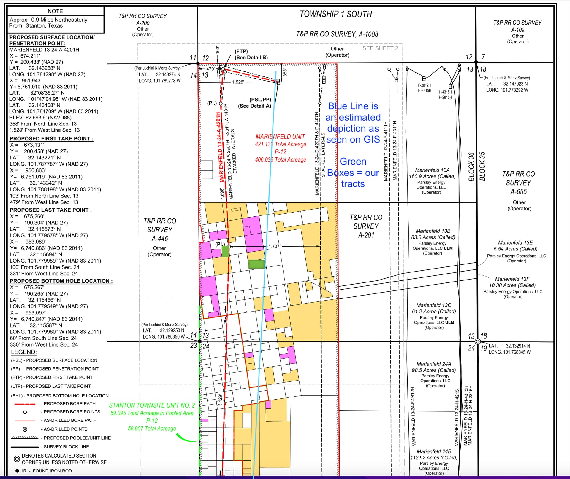
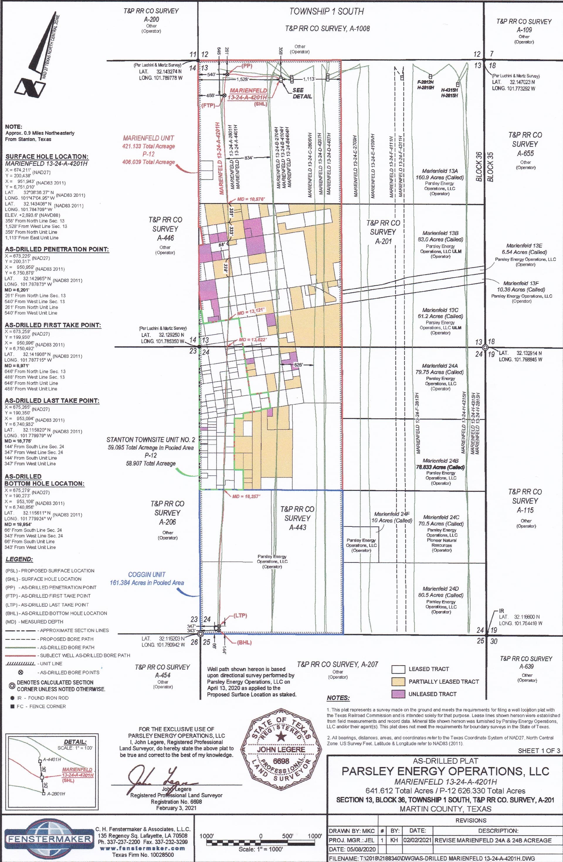
Below is Sheet 1 of 3 sheets that make up the as-drilled plat for the well you referred to. It appears to cover the area where your two tracts are located but you can go to the Well Completions section on RRC’s online site and pull up the completion report to see more detail.
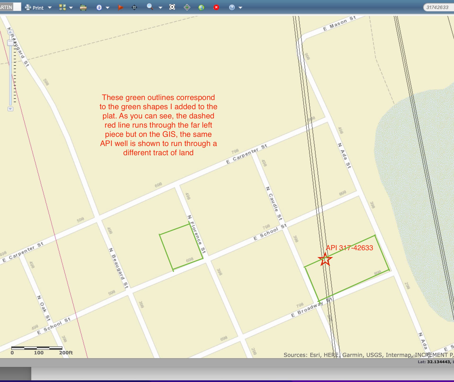
Thank you for the sheet! I will try to find the well completion section and investigate more there. If it helps to clarify, I’m uploading another screenshot but this one is of the actual GIS. When compared to the plat, the GIS shows the wellbore shifted over 2 blocks which is what was originally confusing me.
I am no GIS expert, but I believe the lines from surface to bottom hole on TRRC are an oversimplification of shortest distance from point A to B, not a true depiction of as-drilled.
That is correct. The “stick” lines are preliminary and just connect the surface location to the bottom hole location as initially planned. Royalties will be paid upon the “as drilled” plat which usually has some slight curvatures to it and reflects the actual surface location, the actual path of the well as measured by a borehole survey and the actual bottom location.
Thank you! Would it be correct to assume the borehole survey would be something I would need to request directly from the operator? I have also been researching take points and although the plat shows first and last, I’m thinking the borehole survey you mentioned may have that data as well but can you speak to that information?
Thank you for your response. I assumed GIS wasn’t exact but all the other wells I have pulled up appeared relatively close when compared to the plat but this one was 2 blocks off so I wanted to make sure we were making decisions based on correct knowledge.
Contact the operator for clarification of the pre-drill plat if the wells have not been drilled. The as-drilled is available from the RRC if I remember correctly.
The RRC GIS viewer is not 100% accurate as it overlays sections on the surface. It is not being altered to reflect changes in section lines and tracts based on lat-long notes in survey plats by oil companies. So a well site location on GIS viewer could appear closer to section line or even over the section line. Same for GLO GIS viewer. As noted by M Barnes, the as-drilled plat will set out the exact location of the final wellbore as it generally ‘meanders’ slightly. Based on your notes, your situation seems to involve several small town lots which may or may not end up underlying the final wellbore and you are determining whether or not to lease or remain unleased (or perhaps whether or not to ratify a lease as an NPRI owner). If so, there are financial and legal considerations, including well payout, differences based on lot locations and mineral vs NPRI well DOI figures. You should consider consulting someone with expertise in these matters to make the best decision based on all the facts.
What you are referring to as the GIS path shown on RRC’s map isn’t meaningful for what you are trying to determine. Where there are multiple wells from the same pad you’ll notice the horizontal legs are always depicted as straight lines extending directly from the well site making it appear they were drilled like spokes on a wheel when, as shown on the plat, they have an initial leg followed by a 90 degree turn that makes the actual path of the wells parallel each other.
I doubt you can get any more detail on the path of the wellbore than that “as drilled” survey the operator filed with their completion report.
Yes, we have 3 small in-town tracts that the operator had marked as leased when the unit was pooled and wells completed. It was determined that the majority of heirs are unleased and have to decide whether to ratify the original lease or remain unleased. The operator has not confirmed the exact BPO/APO figure but commented they think they have paid out. To my knowledge, there are 3 stacked laterals that run directly under one of our tracts and another set of 3 more stacked laterals less than 330’ from one of our tracts.
We have consulted an O&G attorney who recommended obtaining more information hoping to make the best choice.
One of the stacked laterals has 100 ft of the 10,000 ft bore under the property and I was told APO interest in the 3 wells would roughly be 0.01% RI in each of the 3 wells so: 100/10000 x 100% MI = 0.01% (I have to further explore if this is the correct calculation). If we ratify, we get 25% of the 9 pooled wells in the unit which sounds like the safer option which some heirs may choose, but if we stay unleased we will get MI for the 3 stacked laterals under the tract (I have to continue my research to determine if we have any claim on the second group of stacked laterals that are close but not directly under the property which is why my search brought me to determining take points).
I appreciate everyone’s input! This has been a tiresome and at times overwhelming undertaking and I appreciate the answers!