I have minerals in Section 25, Block 29 where several new horizontal wells (Bullion 29-0-24-25 A thru F) have been drilled as allocation wells. The Plat says Section 25 is Tract 1 and the acreage is “Called 655.20 AC.” What do they mean “Called”?
Since Section 25 is not 640 acres (1 mile square), is there a place where I can look up the actual dimensions (in feet)?
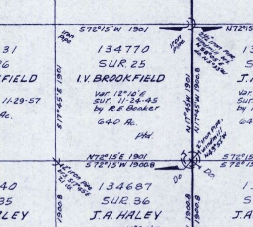
The General Land Office’s records (working sketch 22) that’s below shows 1901 X 1901 varas as the patented dimension for Section 25, which calculates as 640 acres.
On the plat of the Bullion wells the surveyor stated they had shown all the distances required by RRC. The “called” 655.20 acres they noted may be the total acreage they determined by adding up the acreage described in the deeds to the individual tracts within the section.
If Anadarko allocates production from the Bullion wells based on the feet of productive lateral crossing each tract as a percentage of the total lateral length then the Section dimensions wouldn’t be meaningful.
Over the years, surveys have become more accurate due to technology. New surveys of sections in West Texas are frequently finding acreage variances from GLO records, although mostly less than +/- 5 acres. Due to pin locations, better GPS coordinate measurements, and making sure the adjoining section lines meet. Called acreage most frequently is GLO listed acreage, but can be from an older survey when the oil company does not hire a new survey. If a unit had been formed for the 2 sections, then the operator would have been more likely to have a new survey for precise acreage. If you read the surveyor’s statement on the Bullion plats, it is limited to satisfying RRC requirements. He does not say he found the pins and corners and did a new measurement. Dusty is right that your royalty decimal will be based on the proportion of productive lateral wellbore across your section.
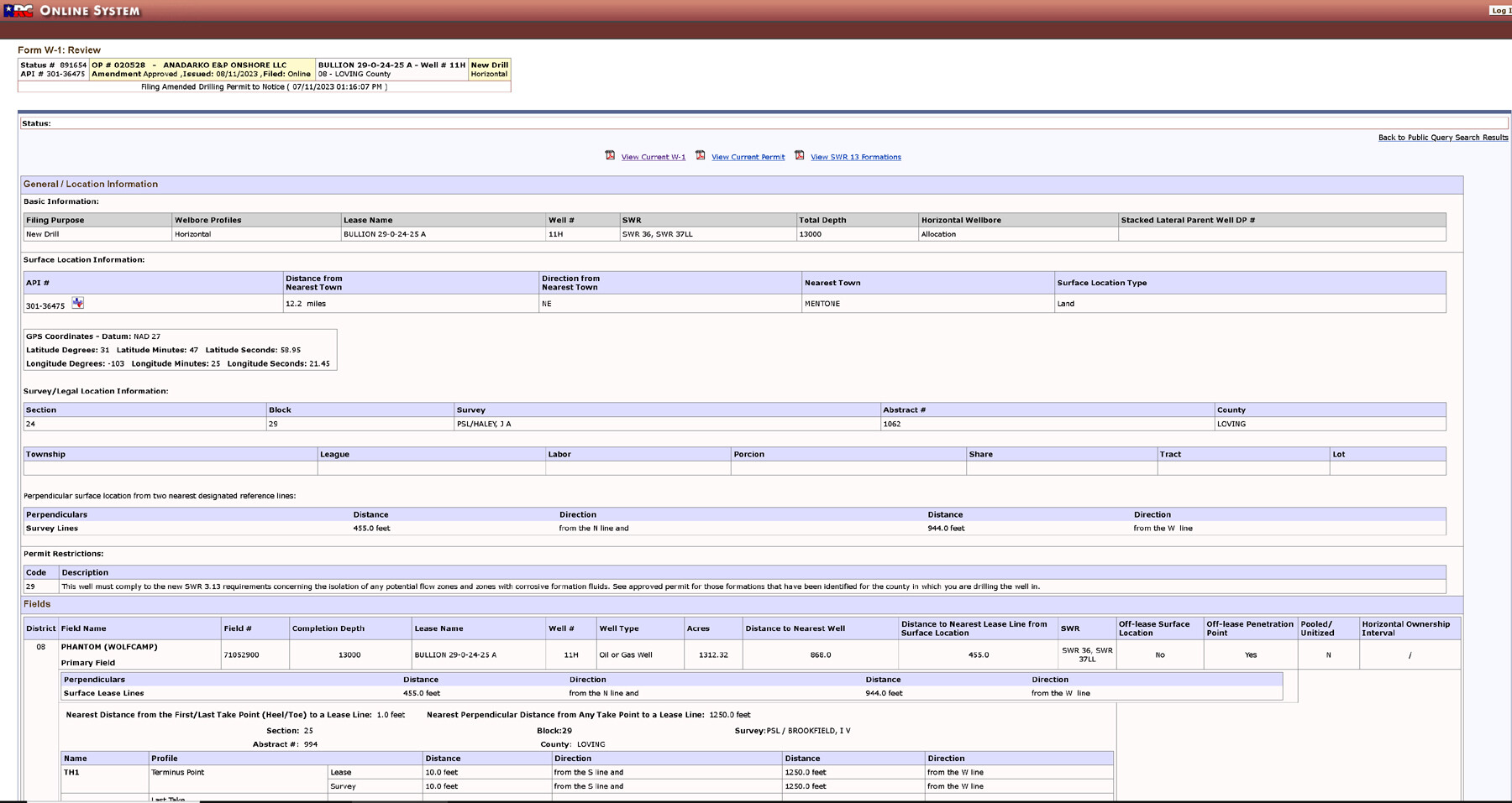
Thank you. My problem is computing the feet of productive lateral crossing Section 25. The Plat gives you the total productive distance - 10,369. It also says that the LTP is 100 ft from the South lease boundary of Section 25. But there is no measurement from that point to the line dividing Section 25 and Section 24. That’s why I was looking for the actual dimensions of Section 25. Am I missing something?
I picked one well for that on the TRRC viewer and this is what I found for that plat so far. There are other permits as well that need to be explored. Hope this helps some? MK
The completion report will provide the productive lateral after drilling and the as-drilled plat will give the productive length in each tract. The final numbers will vary from well to well, so your royalty decimals will not be identical.
The as-drilled plat must not be available yet. The first clue that I needed to look into the calculation of my royalty decimals was that the DO had the exact same decimal for all six wells down to the eighth decimal place.
As-drilled plats and other completion data are posted under Completions on RRC site. Fastest way to find each well is by entering its API number with no dashes. Will be 8 digits - 3 for County and 5 for wellbore and they are on the permits.
TennisDaze: Yes already went there and the Plat does not reflect the productive distance for either Tract. Nor does it give any other dimensions from which you could extrapolate. I requested the info from Oxy/Anadarko. We’ll see how they answer. BTW the API for the first well is 30136475. The rest are in sequence to 30136480.
@George_D_Cato, from the P-16 in the completion report it looks like they allocated based on acreage and allocated 109.2 acres for each well for a total of 655.2. I originally tried to answer your first question using the GIS data provided by the Railroad Commission for the surveys in Loving County. Maybe a rectangle 5275’ tall by 5410’ wide was about as close as I could estimate. It’s really not perfectly symmetric, but those might be workable numbers.
The total productive lateral lengths are set out on the W2 completion form as well as visible on the as-drilled plats. Looking at one, I see the Haley 29-24 6H well and pulling the permit, Anadarko had a formal survey which measured Section 29 as 657.12 acres. So that is where the called acreage for that section is from. There may be something similar from an older survey in Section 25. Keep in mind that the difference in acreage between 657.12 acres and 655.20 acres is 50.0732% vs 49.9268%. As to the productive laterals, the plats have great uniformity in length, with 1st take point ranging from 145 to 215 feet from north line Section 24 and last take point ranging 181-196 feet from south line Section 25. So you would be unlikely to have any significant difference in DOI even if you own a large number of net mineral acres. If one of the wells had been very short or only part of the lateral was fraced, then there would be a decimal difference.
Thank you, Peter and TennisDaze. I should have been more specific. The only information I lack is the productive lateral length in Section 25 (Tract 1) for each well. I have the total productive lateral lengths for each well.
@George_D_Cato, with estimate that distance across Section 25 is very close to a mile, and plat shows around 190’ spacing from section line to last take point, lateral distance should be close to 5080’ or so. As noted by @TennisDaze, the six wells look very similar in distance, but since they all came out exactly the same on your division order I would still suspect they did things based more on acreage. Perhaps the DO analyst will get back to you and then it will be all clear.