My property is in the northeast area of Culberson County, close to the Reeves County line. Recently, an oil company who is not my operator has filed many permits, all of which are for my Block, Sections, and Abstract numbers. However, I don’t have a lease with this company and all the laterals extend out to other sections. I’m having a hard time understanding the horizontal drilling impact and whether I am due revenue. Can they put the drill site and permits in my section and then drill horizontally into another section so that I don’t share in the revenue?
1 Like
Yes, they can. You will only get paid if there are perforations in your section. This is often done near a tract line so that the curvature of the turn from vertical to horizontal is done on the non-perforated property and the horizontal perforations are only in the preferred tract(s). The landowner should get a surface use agreement for the pad being on their property. Drill pads need to be flat, so sometimes they move the surface pad to where the topography is more favorable.
Thanks for responding. I think you have described my situation exactly. I’m disappointed in my operator because others seem to be drilling all around my property. I hope that doesn’t mean they are sucking up all our oil!
They are abiding by the rules of oil and gas capture. The drainage from the wells is generally in the tract they are perforated in. You may end up getting wells on your property as they can re-use the pad in some cases. Time will tell.
1 Like
What is the legal description of the tract you own? I can provide you with detailed information regarding the activity in the area and determine if your acreage is included in the Drilling and Spacing Unit for the well you are talking about.
The properties are Sections 28, 32, 34 in Block 58.
Plat- East 1:2.pdf (2.2 MB) Plat- West 1:2.pdf (1.2 MB)
Joy the active permits you are referring to pertain to Section 32. I don’t see any active permits associated with Section 28 or 34.
M_Barnes was correct the surface location for the 8 wells Chevron has permitted is located in Section 32. However, the Drilling and Spacing unit comprises Sections 41 & 44 so the owners in those sections will be receiving the revenue from the wells if and when they are drilled. I have attempted to provide you with 2 plats, though they do not show all the permitted wells they will give you an idea of what a permit for the drilling location on the east and west 1/2 of the sections looks like.
It seems to me the operators in the 3 sections you referenced have done a fine job of developing your minerals and protecting your assets as there are currently multiple producing horizontal wells in each of the 3 sections.
Thanks for looking at this and for your input. The wells on your plats are Hay Martin. But what I am seeing are permits in Section 32 for Hay Mia Wells and in Section 34 for Hay Maddilyn wells. I’m sure the same applies to those wells, which is that the drilling rig is on the surface in my sections but the laterals are not. You are right about my operator–I am just ready for some new wells since the decline curve is impacting the old ones! Especially since there is drilling all around! Thanks again for taking the time to look at this!
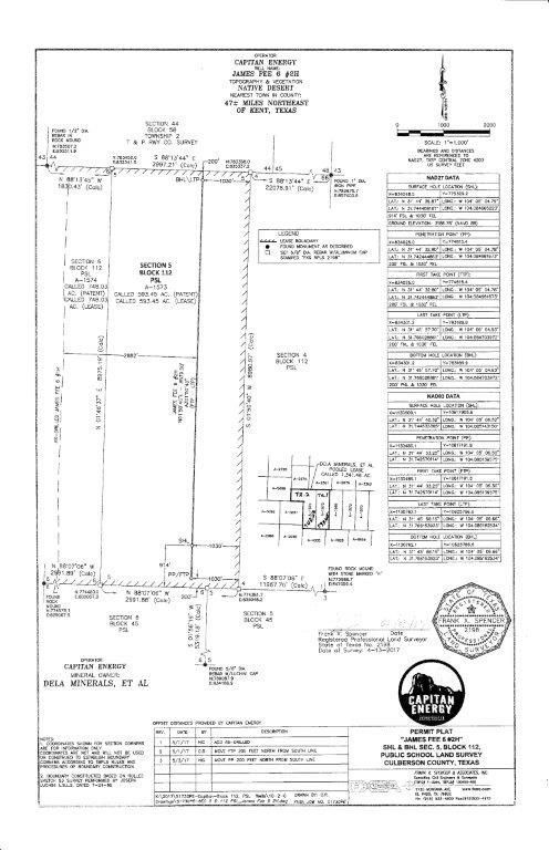
Hello, how to find a map with activity going on in Culberson County. I have 15 acres ab 1573 & 1574 blk 112 NW/pt Sec 5 & 6 PSL par 82-84 Thank you.
Interesting–yours are very close to my sections. It looks like we have the same operator, Capitan, right?
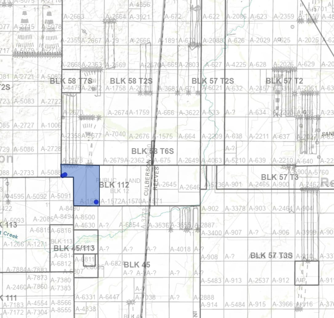
Not sure how you find a map. Here is a map of wells drilled in the last 12 months. You are the blue. Eventually you will get more wells. Capitan probably not as good of a bet as Chevron or Coterra etc.
2 Likes
You are so right. Chevron is permeating the area.
1 Like
Thank you very much for the information. Does it mean that there are two wells on my property if I am in blue? I know nothing. Would appreciate your response.
Thank you very much for the information. Does it mean that there are two wells on my property if I am in blue? I know nothing. Would appreciate your response.
Thank you for your reply. Probably it is Capitan, I am not sure.
Lyubov: The map provided does not show any production in the sections you own. However, I have access to information showing there are two wells you should have interest in, assuming your ownership is undivided across each section you referenced above. If so, you should be receiving income from these wells. Captain Energy is in fact the operator.
Per the plat that I attached, I see James Fee 6, Well 2H, in Section 5, Block 112, A-1573. I don’t know if this is the exact area you own, but it has been producing for several years. Capitan phone is 844-841-1186 and website is capitanusa.com. Good luck!
1 Like
Thank you. I tried to call, but they did not answer. I left a message. Also, I used the contact form on their website. I did not hear from them so far. Thank you again for the information.
Give them time. Operators are notorious for being hard to contact!
Thank you very much.