I am wondering if anyone has info on current values for T42N-R71W 6th PM. Any information would be useful.
Please be more specific in your question. Are you asking about sales offers or lease offers? Both of which would be tied to the royalty amount.
Thank you. I am looking at sales offers. I am also interested in any guidance on reading the GIS map. I am playing with it, but there’s a learning curve. I am trying to see what the activity in the area looks like.
I saw in a previous post a map using arcgis.com This looks like what I am looking for but it seems I would need an account to use this. Is there a free version or another way to gather this information about permits in the area?
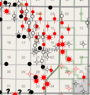
@ShellyG, here is the link to the Wyoming map… no account needed. https://portal.wsgs.wyo.gov/arcgis/apps/webappviewer/index.html?id=d42f571b87fa4234b03d66ca7ae311a4 Here is a screenshot of the Township you referenced. It takes a couple of minutes to go through the layer list and check the items you would like to have displayed.
Once you zoom in you can pick the individual wells and get further details.
This is great. Thank you. I am playing with the layers but haven’t figured out how to see the Township/Range grid you show here. Can you tell me which item you checked to get that information?
@ShellyG, look under Base Layers for PLSS. Check the PLSS and the Township and Section boxes under the PLSS heading. Then the Township/Range (PLSS) grid should appear.
Here’s another: https://dataexplorer.wogcc.wyo.gov/
1 Like
Here’s the activity.
There’s a user tutorial here: https://dataexplorer.wogcc.wyo.gov/DataExplorer_UserHelp.pdf
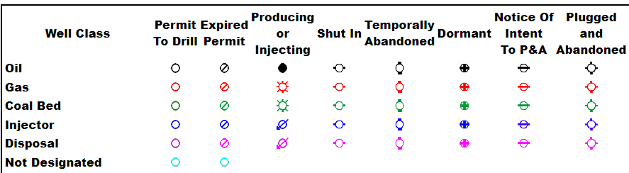
To help determine what each symbol represents, see here:
I like Richard Miller for valuation - 970-690-3880. Knowledgeable and reasonable.
This topic was automatically closed after 90 days. New replies are no longer allowed.