Bull Run Resources Files For Drilling Permit In Robertson County!

Bull Run submitted a W-1 to the RRC this afternoon:

https://webapps.rrc.state.tx.us/DP/drillDownQueryAction.do?name=HADRIAN%2BUNIT&fromPublicQuery=Y&univDocNo=499116667

Surface location will be 10.1 miles east of Hearne in the J Dunn A-7 Survey.

Bull Run has recorded no leases in Robertson County. The only entity that has done recent leasing in the Dunn Survey is Hawkwood Energy. It appears that Bull Run (EOG?) has acquired leases from Hawkwood. An assignment document has not been filed yet.

Target is listed as Eagle Ford at 9,000 TVD, just like their Madison County well.

3 Likes

Is this an oil or gas play?

Presumably oil based on what is stated (Eagle Ford at 9,000 TVD) in the W-1, but can’t really say for sure. The whole situation is just strange. Speaking of strange, the plat for this well shows that the surface hole location is 5,700 feet (more than a mile) from the first take point.

1 Like

Update on leasing for this well: Bull Run recorded 6 lease memos and 5 ratifications in the Robertson County Deed Records on Friday, April 24. These leases covered 1,381 gross acres in the J Dunn A-7 and SA Kimbell A-204 Surveys (the proposed lateral for this well runs through those surveys).

Five of the leases were written from May through August 2025 and not recorded until April 24, 2026. Terms were 5/0 or 3/2. One lease was effective April 23, 2026 and is for one year only.

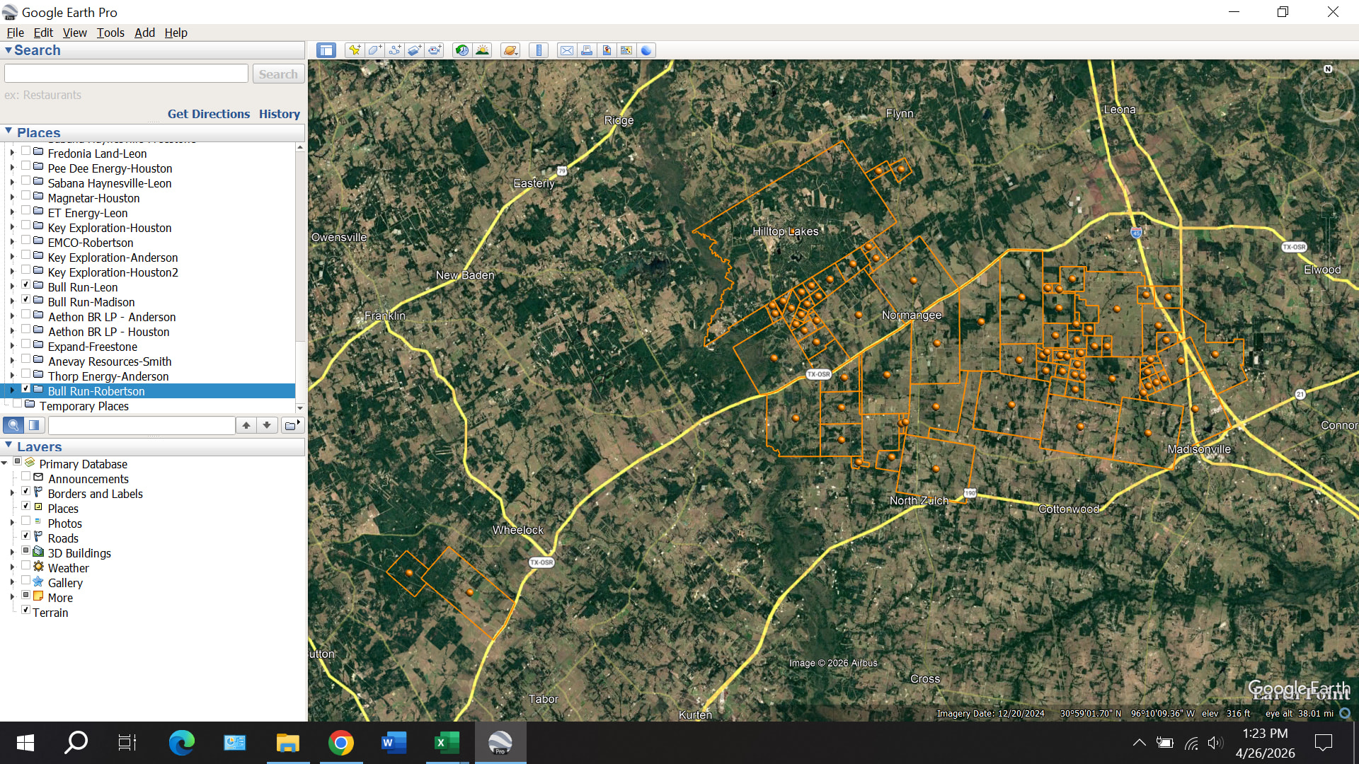
So no confirmed involvement of Hawkwood at this time. Here’s a map of the surveys containing acreage leased by Bull Run in Madison, Leon, and Robertson Counties:

1 Like

Bull Run amended their W-1 by adding a lease that reduced the SHL to FTP distance from 5,700 feet to 2,250 feet.

The drilling permit for this well was approved on April 23. Enverus is reporting a spud date of April 22 (probably the date the rig arrived on site). Nabors X07, the rig that drilled the Augustus Unit 1H in Madison County, is doing the drilling.

Everything is moving at a fast pace on this project. Based on available information, I think it is likely that Bull Run (EOG?) either has a lease acquisition deal in place with Hawkwood or has a tentative deal that will be finalized or cancelled based on the results of the two Bull Run wells permitted so far.

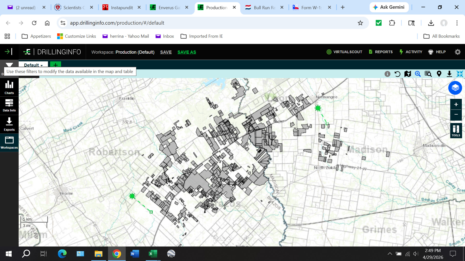
Look at this map showing the Hawkwood lease area in Madison, Leon, Brazos, and Robertson Counties compared to the locations of the two Bull Run wells:

Sure looks like the Bull Run wells were positioned to bracket the Hawkwood lease area.

Hope we get an answer soon!

1 Like

Alan, what does this mean? What’s the significance of the amendment? And what’s SHL to FTP mean?

This is from ChatGPT: * SHL = Surface Hole Location (where the well starts on surface)

  • FTP = First Take Point (where perforations begin / lateral starts producing)

So this is: :backhand_index_pointing_right: Distance from surface location to where the horizontal lateral actually starts

⸻

“from 5,700 feet to 2,250 feet”

That’s a huge change

Meaning:

  • Originally: :backhand_index_pointing_right: Long vertical + curve section before lateral (~5,700 ft)
  • Now: :backhand_index_pointing_right: Much shorter distance before lateral (~2,250 ft)

⸻

:brain: What that actually means operationally

They:

  • Moved the kickoff point closer to the surface location, OR
  • Shifted the surface location relative to the target zone, OR
  • Adjusted lease geometry so they can start the lateral sooner

⸻

:fire: Why they would do this

This is not random — it usually means:

  1. Better economics
    • Shorter vertical/curve = cheaper drilling
  2. Better lease alignment
    • They needed that added lease to legally place the lateral sooner
  3. Avoiding problems
    • Could be:
      • geologic issues
      • spacing conflicts
      • boundary constraints

⸻

:warning: What it tells you (important insight)

This kind of amendment means: :backhand_index_pointing_right: They are actively optimizing the well — not just following the original plan

That’s usually:

  • A good sign of serious development
  • But also means:
    • original plan had limitations

⸻

:pushpin: Bottom line in plain English

They changed the permit so the well: :backhand_index_pointing_right: starts producing much sooner after drilling down

  • Less wasted drilling distance
  • More efficient lateral placement
  • Likely better alignment with leases

I think Bull Run had been unable to execute a lease involving the 215.4 acre tract owned by OSR Ranch, LTD, so they initially decided not to perforate the section of the lateral that ran through it. The amendment indicates that they were finally able to get a lease done.

1 Like

1 Like