Trying to find out the land description of a well using the API # 35-049-24921.
Floyd 1-8 Garvin County, OK.
I need to know the section description to see if I have royalties to this well.
Thanks.
Trying to find out the land description of a well using the API # 35-049-24921.
Floyd 1-8 Garvin County, OK.
I need to know the section description to see if I have royalties to this well.
Thanks.
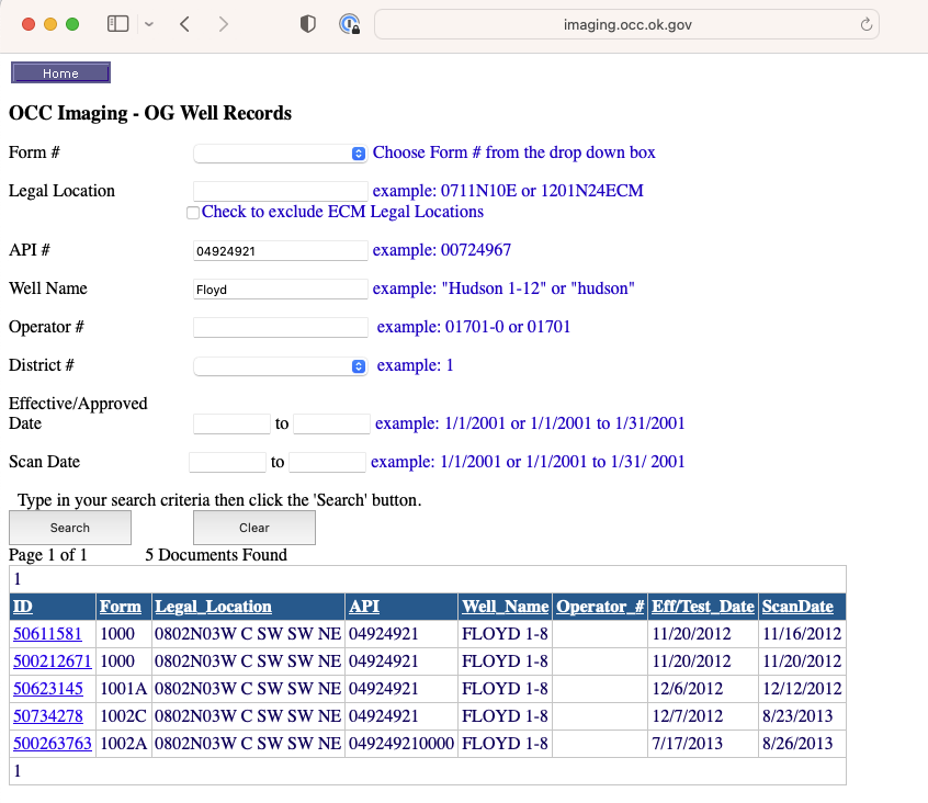
Go to the 1002A completion and scroll down to p. 2. The spacing is 640 acres, so if you have minerals in that section 8-2N-3W, then you should have royalties. The well is not stunning. Don’t get too excited.
However, There are seven to eight more horizontal wells that you really want to find out about. Do you know about them?
My mineral rights are in Sections 3 and 10 of Township 2 North, Range 3 West, and being so close to this well I’m trying to figure if I’m due any unpaid royalties.
I do have and I’m being paid for my interest in the Floyd Garvin: Newfield Expl Mid-Continent, Inc.; Floyd No. 1H-3X Well; N/2 N/2 NE/4 NW/4 (BHL) of 03-02N-03W; TD 20,805 feet.
If you have anything you could tell me about this one I’d greatly appreciate it as well.
Thank you, Mrs. Barns, for all your greatly appreciated support to us who have limited resources and knowledge of this field.
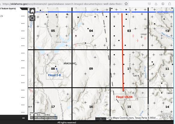
You are in two completely different sections than the Floyd 1-8 (vertical well) which is in section 8-two miles to the west. You will not get any royalties from sec 8 unless you own minerals in section 8 where the well is perforated. Blue well-see arrow just above the “8” in the figure.
Your Floyd 1H-3X is a horizontal well. The X in the name indicates a multi-section well (with 10). It has a surface location in sec 15 and goes north through 10 and 3. Red well two miles to the east.
Floyd is a fairly common name, so it is not uncommon to find wells with similar names. Hope this helps you visualize their distance apart.
Okay the map I was using and looking at made it look a lot closer my mistake these wells are on the Floyd Ranch or in the area of it so that’s why they have the same name. Thank you again
This topic was automatically closed after 90 days. New replies are no longer allowed.