I am unhappy with the long delayed information I can find online from sites like the New Mexico Oil Conservation Division. Ameredev wants big bucks to share information of their drilling on my mineral interests, that seems like all sorts of just wrong. I am interested in the real time status of Ameredev II par 3 wells 30 025 49630 and 49j31, known also as 105H and 107H. Any suggestions?
Not to play devil’s advocate, but if they’re following all the terms of the lease then they’re playing by the rules of the game that you (or your predecessor) set.
The lease controls the relationship between lessor and lessee.
On one hand, you can ask for nearly whatever you want in the lease; it all just depends on what’s in writing and what’s on record.
On the other hand, if it’s not in the lease, then it’s up to each party to decide what they want to do voluntarily (you know, within reason and legal limits). They aren’t NOT allowed to send you reports – if you made friends with someone there and they WANTED to send you report, they certainly could – but making them provide something they didn’t agree to provide would be changing the rules of the game after the game starts. There could be 100’s of royalty owners in each well alone, and hundreds of reports per well each month depending on levels of activity. Not only is it logistically difficult, but those owners could include their competing operators or competing investors who they don’t want to have access to their secret sauce (at least in real time), or at least would want to be able to plan for it.
Most JOA’s allow all working interest owners access to any report requested, but WI owners at least have skin in the game. It’s like if you have adult kids living with you, you’re probably hands-off their life (other than what they voluntarily share) if they’re paying full rent and not depending on you financially in any way. But if they’re living rent-free and you’re paying their phone bill, you probably get access to more info on what they’re doing with their time (at least, in my house that’d happen…).
If you want to get crafty you could try to find a way to purchase a sliver of working interest…that’d get you data at least within 30 days or so of it happening rather than waiting for it to get filed publicly, but even that can be a headache for experienced WI owners.
disclaimer: I’m not a lawyer or legal expert
2 Likes
The wells were drilled back in January from what I can see in the database and there were detected frac crews in the area of the pad during March. If that is true then they should be on flowback right now. Others may have other suggestions but “real time” status can be hard to get unless you have a good contact in the land department. Most of the time Operators are pretty open when a well is being completed, flow back, etc. State sites are at the mercy of the Operator and so unless you have a site that compiles state, federal, and private data sources it can be rough to get up to date information.
Thanks Tracy, that does help a bit, but with the computer age, sending out hundreds of emails to all mineral owners can be done totally automatically with only having to input a sentence or three of status, nothing that I can see would provide the competition with any valuable information and would be a courteous thing to do. I do understand there is no profit to the operator gained by being courteous, it is just the “right thing to do”. I did ask for a status from the operator, and got an immediate response that they would be happy to furnish me that information. Two weeks later I am still waiting for that.
Success! I got the following answer from Ameredev today, but it actually raises more questions. It appears to me that they are in error on 103H; it seems to clearly NOT be in the SE part of Section 7. Sure nice to know the exact status of the 2 wells though, eases my anxiety level!
Donald, Ameredev is drilling three wells that include subject lands being S2SE4 Section 7, Township 25S, Range 36E, in the unit. These wells have been drilled. They are being completed now and will start production in the next 10 to 20 days.
The wells are PAR THREE FED COM 103H, 105H, and 107H; division orders will be mailed out soon if not already. You mentioned a 114H, but we are not drilling a well under that name in this area.
Please let me know if you have any questions.
Regards,
I think you covered it with the patience pill.
Oil companies are busy. Land department and division order sides of oil companies are SUPER busy, seeing how everyone is selling/transferring/chopping up their minerals all the time now. Clean up title, transfer title, get new DOTO out for new drills. Your division order analyst is likely ready to snap. If they aren’t telling you to jump into a creek, you are probably ahead of the game. Sending you every bit of data may seem like the “right thing to do” to you, but for them it’s a great way to put themselves in a spot where they are on the phone nonstop having to explain every acronym in a daily drilling report to the very curious guy in Harlingen. Which is not the right thing to do for them. Don’t get me wrong, there is nothing wrong with being the curious guy in Harlingen, but sometimes that guy needs to get used to disappointment. ![]()
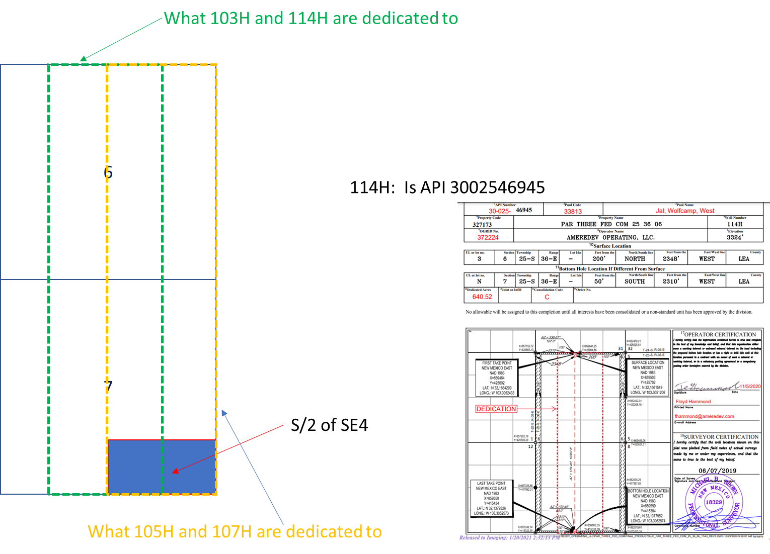
And fwiw, it looks to me like the SE/4 of Section 7 should end up also owning half the interest in the 103H and 114H as it does in the 105H and 107H. (They are dedicated to the W/2 of the SE/4 and the E/2 of the SW/4). So you probably have interest in 4 Par Three wells. I think. Just glanced at it.
There is downtime and delays between all steps for a well. In general. Well is spud. Wait 120 days. Well gets frac’d. Wait 60 days. Well starts flowback/cleanup and then sent into permanent facilities. Wait 60 days. Initial production information shows up at NMOCD. Wait 60 days. Get Division Order. Wait 30 days. Mineral owner gets initial check for the first 3 months of production. Something like that. On average. A year from spud until you get a check. Sometimes shorter, oftentimes way longer, but this is 2 well pads, it should move reasonably quickly. Like Phil said, there was a frac crew working the western pad (not your wells, the 101H and 112H) in March/April. Wheels are in motion, but it’s not a real-time process.
It’s not just you Don. This is the business and the feedback loop pace. As a hobby/pseudo job, I check into the mineral/ORRI interests in hundreds of wells for a local company/fund. I’m a curious guy. I’m generally more informed than most mineral owners. I’ve got access to some software, satellite images, etc. I kinda know how things work. I know people at oil companies. Sometimes I’ll drop a Starbucks gift card on folks to grease the skids. I care more than I should, I kinda feel like they are my wells even though they aren’t. And there is a lot of stuff where I can’t figure out what the heck is going on. There is a group of wells that have made over 500,000 bo since Nov 21 that I haven’t seen a DO on. Zilch. Conoco claims it’s a Concho transition problem. Shrug. These guys are getting paid on some Matador wells in Eddy County for over a year, and there is zero production info in the NMOCD. Nothing. Yet the check comes with X000s of barrels of oil on it. I’ve contacted all of these people. And sometimes you just don’t get an answer. You make peace with the fact that in the end it has historically worked out more or less as it should over time. At some point, on a very tiny fraction of things, you call a lawyer. But not when your NRI starts with three zeros.
2 Likes
Thanks so much NMOilboy! I really mean it. I never heard of half interest in a well bore before, makes some sense. Here is the response I got from AMEREDEV when I tried to point it out to them: I must be missing something in map reading I guess. Here is the answer from AMEREDEV to questioning the 103H location:
Don, Please see attached PLAT for PAR THREE 25 36 06 FED COM. The unit covers the E2E2 and the W2W2 of Section 6 and 7; therefore, the SW4SE4 is included in the unit for that well.
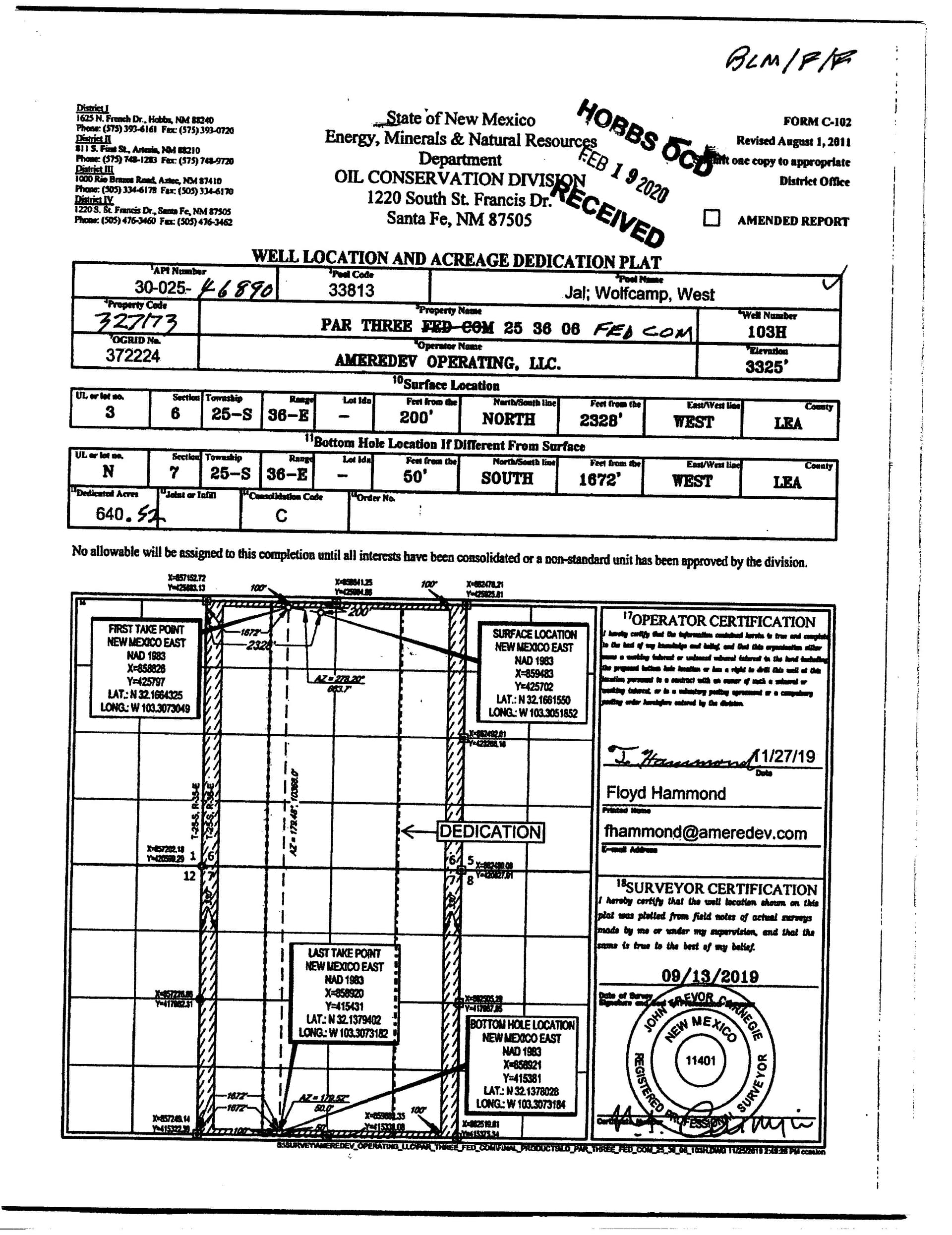
Still confused. My interests are Township 25 South, Range 56 East, Sections 7, 2, Southeast quarter. Both AMEREDEV and NMOilboy state I have an interest in this 103H well described above but for the life of me I cannot understand why. Obviously I still need some basic location map reading instruction.
103H is dedicated to the SW/4 of the SE/4 of Section 7. See map below. So when I said “half interest” I mean you would have half of the interest in the 103H well that you do in the 105H and 107H. (Since the 105 and 107 are dedicated to ALL of your acreage and the 103H is dedicated to half of it). So if you had .0002 in the 107H you would have .0001 in the 103H.
I’m sure Ameredev knows if they drilled 114H or not. Drillinginfo claims they spud it on 12/6/2021 but that might not mean anything.
As always, thank you so much again!! I suspect you are thinking “why doesn’t this dude get a hobby or something”!
I had come up with the same figures, but they were “obviously” incorrect since that portion could not possibly be “Double Dedicated” like that. My little brain wheels are spinning again though, why would they do that?
I am assuming that a “dedicated” area MAY have several wells on it?
Um… I’m assuming this IS your hobby.
And yeah I didn’t look at it very closely. I assumed they weren’t in the same pool (horizon essentially) and didn’t look at all the acreage dedication plats. My bad. In the same pool the dedications shouldn’t overlap. You can have more than one well in a dedication area, but you shouldn’t have the same acreage (at the same depth horizon) in more than one dedication area.
After closer look it seems it’s like this (excluded 114h based on what you said). All the wells should have roughly the same interest (to you).

Now it is making sense to me. The only remaining question I have (how many times before have you heard that) regards the “dedicated area”.
For instance, in the above diagram if a well was bored close to just west of my interests but not on my interests, do I share royalties the same as if it were drilled in the middle of my interests since they would be sucking MY oil?
You don’t own anything if your acreage is not in the “dedicated area” for the other well. A well drilled anywhere in the green or yellow box (whether it goes through the blue or not in your case) is owned proportionately by everyone with ownership in that box.
That seemed to have some good info on horizontal wells in New Mexico, a few years old. I just glanced at it but probably would do me some good to read that as well, in my past life everything I did was inside a 70,000 acre Federal unit so we didn’t worry a ton about offset operators/leases.
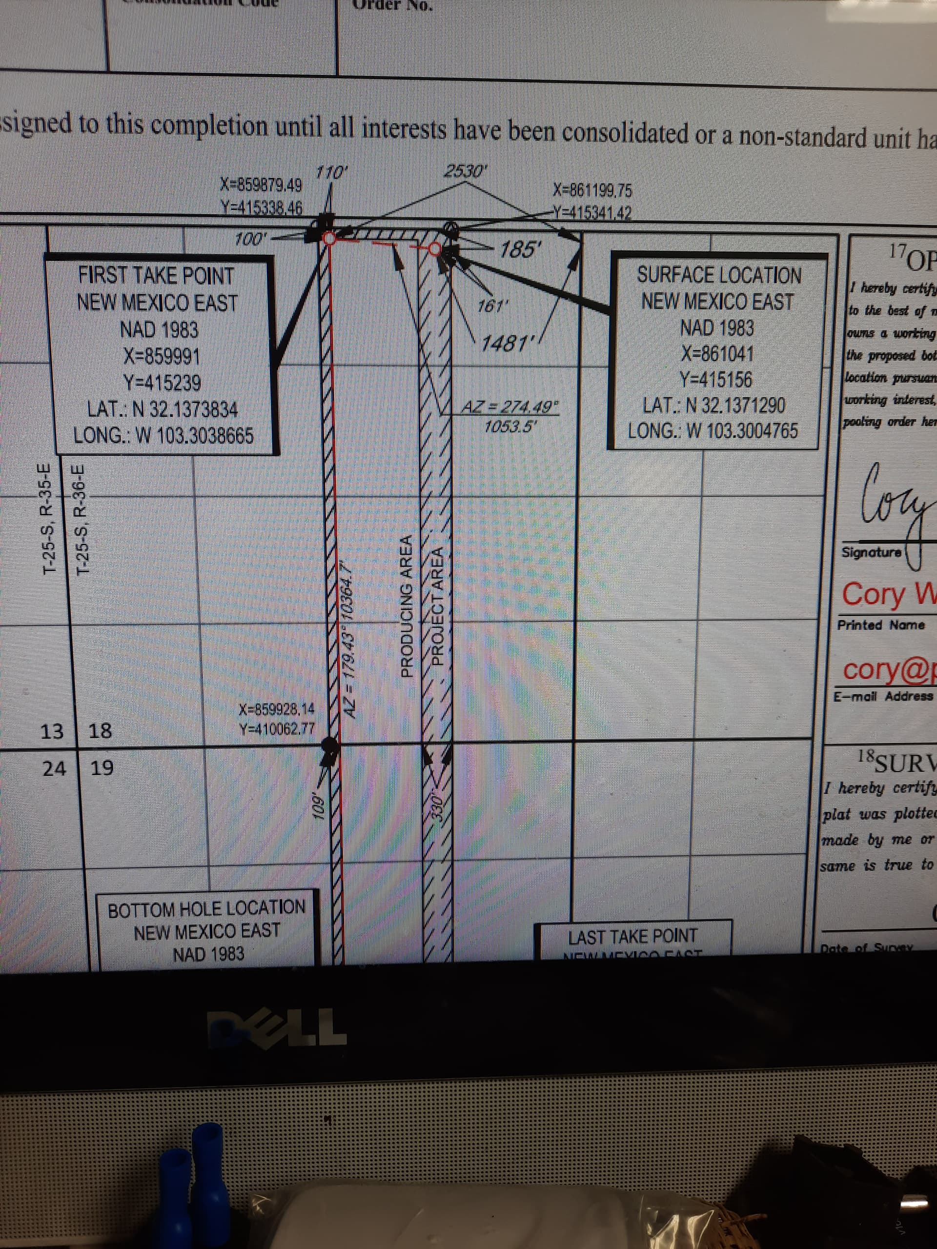
The general rule as far as I remember is that a well has to be offset/setback from the dedicated acreage area. It can’t be within 330’ of the boundary parallel to its path, and the “ends” of the well have to be 100’ from the dedicated area box. “Ends” being the FTP (first take point) and LTP (last take point). In other words, where the lateral was perforated. So nobody can put a well right on your line without a hearing and would need NMOCD approval. 330’ away, yes.
Thanks, well understood now. It even answered the questions I had not yet even asked. Feeling educated and content now, I appreciate your teaching me all that.
OK, I said I was done - I lied!
Trying to apply my newfound information to Section 18, just below the above referenced interests, I found they do not even USE the designated area term, not sure what they mean by this:
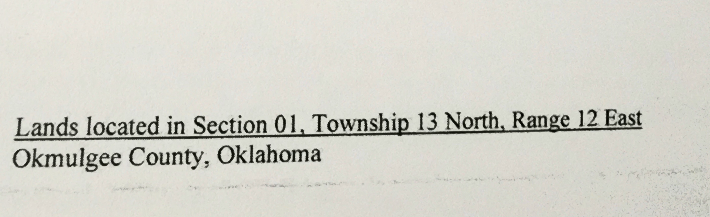
I’m seeking help with a signed lease for Okmulgee, Oklahoma after which there was no correspondence.
I answered you in another feed. Need the section, township and range.
I’m gonna assume that’s the Black Marlin 203H. It’s dedicated to the 320 acres outlined there. Dedicated Area, HSU (Horizontal Spacing Unit), etc. The blue box below. 1/4 mile wide and 2 miles long. The “protected area” in that pic means the 330’ setback from that 320 acre box that they are required to have for a standard location. They are not honoring that on the West side of the box, which is why they have a giant document from Slipping Jimmy McGill Esquire at Holland & Hart in the well file applying for an unorthodox well location.
Which IMO is baloney, if they want to drill a well down the middle of Section 18/19 they should have to include the 320 acre strip to the West of there. But that’s why there are lawyers and that’s why somebody would have to protest it. I don’t know what went down but I assume that was approved and drilled as per that plat.
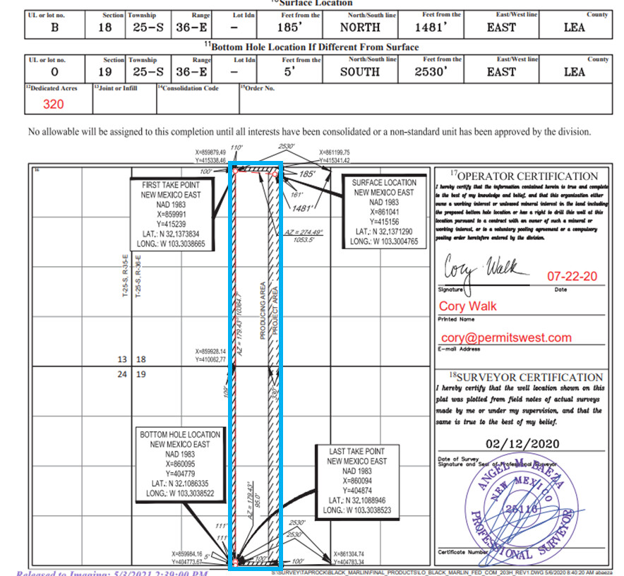
Odd, I thought that page always had that on it. My portion of Township 25S, Range 36E, Section 18. Only the N2, NE 1/4 portion.