I have been presented with a division order that appears to arbitrarily allocate royalties. I am in the 643.2-acre section with the initial take point that is only allocated 22.996%, whereas 2 other smaller sections (481.65 acres with 40.2% allocation and 320.825 acres with 36.809% allocation) have higher allocations. There is no explanation of the differences nor is there an enclosed survey to explain. Is this the usual expectation in Texas? I do not have an explanation yet from Continental.
2 Likes
Allocation by acreage is used where there is a pooled unit. Most likely this is an allocation well. The production is allocated based on the percentage of productive lateral wellbore across each tract. Productive lateral is the distance from first take-point to the last take-point. Look at the as-drilled plat filed with the completion report to see the total productive lateral and the breakdown among the tracts. Apparently only 22.996% of the wellbore is on your section. If your tract is not in a unit, then your DOI will depend on your proportionate interest in the tract. If your section or tract is part of a pooled unit, then the DOI will depend on the unit allocation.
It is a good idea to verify your royalty decimal before signing a division order.
3 Likes
I initially suspected that the answer to your question would be as simple as your section not having as much wellbore in the productive zone due to the transitional zone between the vertical and lateral sections of the well. The drill bit doesn’t go down a “y-axis” to total vertical depth and then shoot out at a right angle and travel along the lateral “x-axis.” Instead, there is a sizeable curved transition zone connecting the vertical and lateral segments. I thought you might have lost out due to the curve not being able to be fracked.
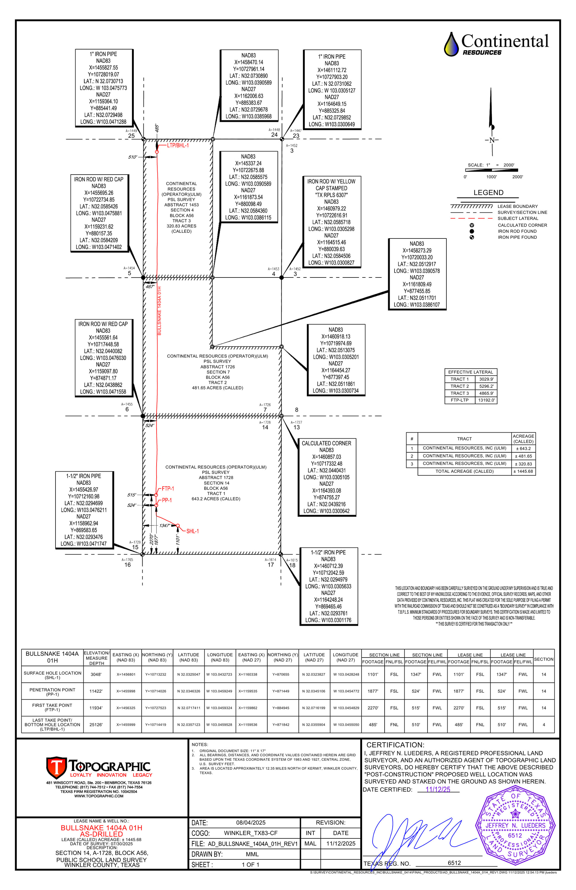
But after looking at the RRC permit and the Bullsnake well plat, I am thinking that your division order may be informed by the pro rata productive lengths of the wellbore in each of the three sections. The plat shows that from the drilling pad, the wellbore is drilled in a southwesterly direction toward the west section line of Section 14. From there the wellbore appears to run parallel to all of the west section lines, which is not what the RRC map viewer shows. The plat indicates that the First Take Point in Section 14 is 467’ north of the south section line and that the Last Take Point nearly three miles away is also 467’ from the north section line. The same plat has a chart which reveals the “Effective Lateral” lengths for three tracts:
Tract 1 - 4,823’ [your tract, Section 14] Tract 2 - 5,288’ Tract 3 - 4,819’ ——————– FTP to LTP - 14,930’
If the division order production distribution percentages were solely a function of the effective lateral lengths divided by 14,930’, it seems as if Tract 1 would be 0.3230409 which is roughly the expected 1/3 given three sections. As I have stressed in other posts, I am a layperson outside of my ken here, so take with a grain of salt my guess that for whatever reason(s), your tract’s portion of the wellbore received fewer total fracked feet per running foot of wellbore within the FTP-LTP length and that your lease allows the company to divvy up the production in this way. Hopefully a forum expert will come along and correct deficiencies and outright errors in my post.
Plat map: https://webapps.rrc.state.tx.us/dpimages/img/8200000-8299999//PR0008268671_0001.pdf
Permit: Form W-1: Field List
2 Likes
You must use the As-Drilled plat filed with the completion report to accurately determine the DOI. The permit plat is only a plan and the final numbers can vary significantly due to drilling and completion issues. Go to RRC online queries and completion reports. In this case, the As-Drilled plat shows that the productive lateral in Section 14 is 3,029.9 feet out of a total productive lateral length of 13,192.0 feet, which is 22.968%. https://webapps.rrc.state.tx.us/dpimages/img/9000000-9099999//PR0009007812_0001.tif
5 Likes
Bravo! According to the as-drilled map, the well was not drilled back toward the south Section line and then up, but rather in a northwesterly direction and then up, making the actual First Take Point 2210’ from the south Section line.
2 Likes
Thanks for the info shared in response to my question regarding the royalty interest CRC has given me as my share of the 3 mile well. I greatly appreciate the detailed information that has allowed me to confirm what CRC says my interest in the well will be.
3 Likes
You’re welcome. Glad to help, or at least try to help.
2 Likes
Hi AJ11 - Thanks again for this great information. My Dad and I were reviewing it tonight and the as-drilled map was essential.
3 Likes
If a land or mineral owner has the drill site on his interest (tract) and none of the well bore perforations are under his tract, is there a way or language that he will get paid out of the company’s interest?
No. Surface owner has right to allow the well site to be located on his tract and negotiate compensation for surface damages and use. Mineral owner cannot prevent this use.
2 Likes
If a mineral owner owns 100% of the mineral rights and 100% of the surface, could they stipulate in their lease that if the drill site is located on this tract, if a horizontal well bore is not perforated on his tract, that the oil company has to pay a % of the revenue from their interest? I’m not referring from the mineral interest of the mineral owners of the other owners in an allocation well. Also, if a 100% surface and mineral owner can stipulate in their lease that no surface operations can take place on their tract. I’ve had that in numerous lease tracts before in the past.
1 Like
You can negotiate whatever terms a lessee will agree to. Enforceability depends on exact wording. Right of oil company to use an off-site well location depends on state law, legal cases, and any surface agreement. No set answer as far as I know, so you should consult your oil and gas attorney.
2 Likes
Thank you for the kind words. I am glad to try to help, but feel it is necessary to point out that TennisDaze informed us of the existence of the as-drilled map. It will be interesting to see the next reported month of production for the Bullsnake well.
1 Like
Got it - still trying to access that blasted as-drilled map on RCC so we can review others, but unable to find it still even with the instructions from Tennis Daze. I can bring up the well with the API number and open the W1, and even bring up the map - but I can’t find that ‘completion’ link anywhere.
1 Like
I couldn’t find a link either, but I have it in my documents. FYI, the tif format will not upload to this site, so I used the free online converter Zamzar to change to a jpg.
1 Like
The W-1 is part of Drilling Permit records. You need to search the completions records. #1 RRC Queries (Online Research Queries). #2 Completions Query. Launch Application. #3 Opens window titled Well Completions with 2 choices. Select Completions Query (yes sounds redundant). #4 Opens window titled Completions Query with various Search Criteria. Simplest for you is to enter API number 49535067 with no dashes or spaces. #5 Opens window called Records Found. Click on Tracking No. #6 Opens window called Form Summary. Select view to open the records. Here you find W-2 which provides the production testing, the vertical depth, total depth (vertical + horizontal), etc. Plat at bottom is the As-Drilled plat which lists the horizontal wellbore length in each section. Hope this helps.
3 Likes
Thanks TennisDaze, I was able to find it.
1 Like
This topic was automatically closed after 90 days. New replies are no longer allowed.