Alfred B. Davis Survey A-16

Just joined Mineral Rights Forum and this group specifically today. I need a lot of help quickly.

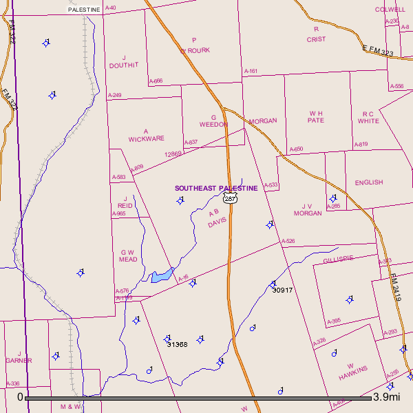
A landman contacted my step-father in early 2013 shortly after my mother passed away in late 2012 looking to lease up some mineral rights located in Anderson county, specifically within the Alfred B. Davis survey A-16 (near Palestine).

First of all, this is all new to me - perhaps it would have been to my mother, as well - since the rights belonged to my great-grandfather. He and my grandmother were estranged. She used the name of her step-father growing up so I didn't even know the man's name until now.

My step-father hired an attorney who worked most of last year on getting the title straightened out and by then the landman with Kodiak Exploration, LLC (anyone know of them?) was no longer interested.

Now they are once again contacting us. I have the unfortunate position of being the main point of contact on behalf of my brothers and cousins and know absolutely nothing of what I am doing.

I can't tell what field - if any - this survey land sits over. So I'm not able to search for what activity there has been, what value there might be or who the production companies are working the area.

My family is in California (so naturally we're paranoid of litigation) and know nothing of Texas O&G leasing. We don't know what we don't know, as it were.

The lease is probably boiler plate but according to MineralWeb.com a lot is negotiable.

How accountable are we as mineral rights owners and not the land owners to whatever happens on the surface? Does the landman also negotiate with the surface owners for property access for exploration and drilling as well? Can the land owner sue the mineral owners if there are damages?

Our shares are on three different tracts - all within the same survey. Should these be contracted separately?

If I get to picky, do I mess up the whole opportunity?

What is reasonable to expect and unreasonable to ask?

Thank you for any specifics you can offer. I know I've written a lot here - hopefully pertinent and not too much fluff.

Bradlee,

It would help if you would let us know how much per acre, royalty percentage, and how many years the offered lease is for. I have looked at the GIS Map and I see no activity or production anywhere close to your A-16.

So that makes your negotiating power sorta weak. All these blue circles with a 1 beside them are dry holes drilled in the past. With the technology of today dry holes of yesterday don't mean much today.

A-16 is approximately 2 1/2 miles southeast of the city of Palestine.

GIS(Geographic Information System)map of Anderson County, Texas A-16 and surrounding area:


Clint Liles

Bradlee

Think you came to a good place for some help. You said you needed help quick so I'll share what I can but my suggestion is, don't feel pressured by time or otherwise to make any commitments before you learn what you are working with.

Alfred Davis Survey A-16 is about five miles south of downtown Palestine. If you want to find it on a map Hwy 287 going to Crockett goes through it. The Railroad Commission is the State authority that regulates oil and gas activity in Texas. The only past activity their map shows in that survey are two old dry holes, that were probably shallow wells drilled in the 1960's and would have no impact on what's happening now.

The main thing you need to be aware of is that in the last two+ years a lot of leasing activity has taken place in Anderson County primarily in an area forming a wide band starting at the southwest side of the county and extending to the northeast side, and on into parts of adjoining Cherokee and Smith County. The Davis Survey is in that general area. Most of that leasing has been done by Kodiak and similar LLC shell companies that are now understood to be leasing on behalf of EOG Resources, although I wouldn't be surprised if the landman you are talking to denies that.

If you aren't familiar with EOG do a Google search and I think you will understand why people feel it is significant that they are the company interested in that area. After getting a large block of leases put together EOG in the past three months drilled two vertical wells that are being viewed as test wells in advance of horizontal drilling. If you will read the earlier Anderson County posts on this site you should find discussions about those wells, called the Mathis and Autry, and about a well called the Cowan in the southend of Smith County that was also drilled by EOG.

You referred to owning mineral interest in three separate tracts in the Davis Survey, but didn't say how large those interest are. Several of your questions about the leverage you might have in negotiating a lease may come down to how many acres those mineral interests cover. You also mentioned negotiating on behalf of other interest owners, which I think is definitely the best approach...in other words, get everyone you can to agree they will work together in trying to negotiate the best lease possible. It can be tough to be the point man on a deal like that but it's a lot better than not having one.

Regarding your question about whether those three separate tracts should be covered by separate leases, my recommendation would be to negotiate on them as a package but make it clear to the landman that you want each one covered by a separate lease. In the same way, I would try to cover the maximum number of mineral owners possible in your negotiations but have it understood each owner needs to end up with their own separate bonus check.

A simple answer to your questions about the liability a mineral owner might have regarding the surface owner of the tract is...not much. Check it out with a lawyer but I think you will find in Texas the mineral interest is dominant. If you are really worried about that you could base your negotiations on having a "no drill" type lease that only allowed pooling or directional drilling from another site, no surface use. You need to realize though that limitation could make your lease less appealing. You could also require that the lease include a provision that any surface location had to receive the prior approval of the surface owner, but I think you will find that liability associated with a leasing company not satisfying the surface owner shouldn't carry over to the mineral owner signing a lease.

If you feel comfortable doing it why don't you post the basic terms you are being offered and also some information about the size interest your family owns and I expect some other folks will have suggestions for you about what you might expect on a lease.