My sister and I own the mineral rights on 60 acres a few miles south of Carrizo Springs, Texas.
How do I locate information about who if anyone is drilling in or around this area and what to do about leasing our mineral rights?
We do not own the surface of this acreage. We hired an attorney to check any legal issues down there and he reported all the proofs of ownership were filed.
Who do I write in Austin to ascertain if there has been any activity that should have been reported to us concerning our mineral rights.
Do you have an Abstract #, Section and Block # for these minerals? With the legal description I can pull up the GIS Map and tell if there is any activity in the area.
This link is to the Dimmit County Group. You might want to join.
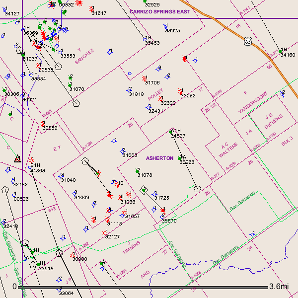
This is what I have: South of Carrizo Springs between Texas Hwy. 1556 and US Hwy. 83, 60 acres, more or less, and being all of Lots Nine (9), Ten (10) and Eleven (11) in the 1460 D.W. Light Subdivision, A.A. Polly Survey #21, Abstract #1226, according to Plat recorded in Vol. 1, page 3, Map Records of Dimmit County, Texas.
After checking the GIS Map I see some production in the past in your area. A fairly decent Oil/Gas well was drilled in 2012 directly to the south of your Section 21 in Section 19.
Link to Completion Report on well API # 127-34527:
Also in Section 19 Well API #127-32957/oil well/ 1990/Austin Chalk Formation. I see several plugged oil and gas wells in the surrounding area of your Section 21. I see several Horizontal and vertical wells to the west and northwest of your minerals.
GIS Map of Dimmit County A-1226/Section 21 and surrounding area:
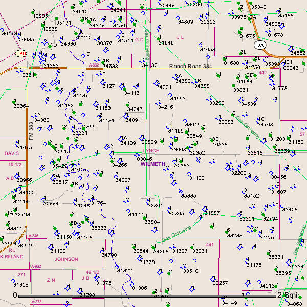
Mr. Liles, perhaps you can assist me, or direct me to whom I need to contact. I inherited “a non-participating, term royalty interest in Runnels County, being 172 acres of land, more or less, out of Block #16 and #9, both being subdivisions of Survey #442, John L. Lynch, known as Abstract Number 346; as more particularly described by metes and bounds in deed from Grady Poe, et al, to Harold Poe, dated 4-18-73, recorded in Volume 431, page 490 of the Deed Records of Runnels County, Texas.” As a native Californian, all of this is foreign to me. I simply would like to find out the status of the land. I have phoned Runnels County Clerk and Attorney offices, but receive no reply. I am just not sure of next steps. I appreciate any wisdom or direction you can share. Audrey Poe
I see numerous dry holes, oil wells and plugged oil wells in Runnels County A-346 and surrounding area. The latest activity I see in the area was a permit issued 05/28/2014 (API # 399-35429) not sure if this well has been drilled yet.
Well # API 399-35369 drilled in Jan 2013. Link to completion report:
Thank you, Mr. Liles! Is it unusual that I have not been contacted when activity is taking place?
Hello Audrey,
I see numerous dry holes, oil wells and plugged oil wells in Runnels County A-346 and surrounding area. The latest activity I see in the area was a permit issued 05/28/2014 (API # 399-35429) not sure if this well has been drilled yet.
Well # API 399-35369 drilled in Jan 2013/Link to completion report:
If activity has taken place on the land, is it odd that I have received no correspondence on this for a number of years?
Audrey Poe said:
Thank you, Mr. Liles! Is it unusual that I have not been contacted when activity is taking place?
Clint Liles said:
Hello Audrey,
I see numerous dry holes, oil wells and plugged oil wells in Runnels County A-346 and surrounding area. The latest activity I see in the area was a permit was issued 05/28/2014 (API # 399-35429) not sure if this well has been drilled yet.
Well # API 399-35369 drilled in Jan 2013/Link to completion report:
If I were you I would be calling Enrich Oil Corp./Abilene, Texas about well API 399-35369 and Southwest Resources, LLC/Brenham, Texas about well API 339-35429.
This link is for all approved operators in the State of Texas including Enrich and Southwest Resources and includes contact numbers and addresses: