My grandmother left my father "7.39 acres of real property located in Carter County, Oklahoma, described as:
"SECTION 05 TOWNSHIP 05S RANGE 01W
"SW SE-W/2 SE-SE SW-E/2 SE
"NW-LESS 1.69 RR.
"1/16 UND INT.
“, together with my right, title and interest in any oil, gas or other minerals located thereon or thereunder.”
My father passed away last year and I am in possession of the original notarized copy of my grandmother’s will. I know that Williford Energy Company leased some mineral rights related to this property, but learned today that they sold their lease to Williford Resources, LLC. I am waiting to hear back from them regarding the status of the lease.
My question: how do I find out where this land is specifically? Any chance there are pictures available - I live in Texas, which isn’t too far? Basically, where do I even begin? Thanks for any advice.
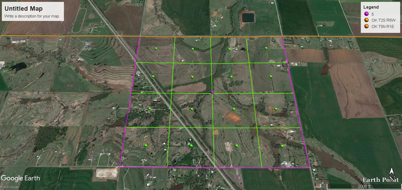
Welcome to the forum and condolences on the passing of your father. I am attaching a nice map of Carter County so you can locate the acreage at least at the section level.
The descriptions usually have a comma or a semicolon instead of a dash. The punctuation really matters. Do you have it another form? Then I can narrow down the location correctly. Perhaps the lease document has the description with the correct punctuation.
There was quite a bit of activity there for many decades. There are two wells still on production in the section, but you may or may not have any royalties due from them. Your acreage must be within their spacing unit. Williford Energy Company has the Reynold-Duke wells 5 & 6 in the NW4 and the T. Gooding Tr 1 in the NE & NW4. Reid Williams has the Sullivan well in the NE4. Contact Williford Resources to see if there are any remaining royalties due to your family.
To visit the property, take I-35 about 31 miles North of the Oklahoma-Texas line.
Take Exit 31 West on Highway 70 in Ardmore, Oklahoma.
Turn South almost 4 miles from the Lone Grove, Oklahoma Post Office.
In one mile the road will jog West, then head South again. When the County Road starts South again, you will be at the NE corner of Section 5, Township 5 South, Range 1 West. Exactly 1 mile further South will be the SE corner of Section 5.
Do you mind if I ask how you know this, Ann? Are you familiar with that area or did you extract that from my description? If from the description, can you translate all of that for me? For example, what is “SW SE-W/2 SE-SE SW -E/2 SE NW-LESS 1.69 RR?” Do you know if there is a railroad out there anywhere? I am fairly certain the reference to “less 1.69 rr” is a reference to a railroad, but 1.69 what? What is the unit? Miles?
I live in Ardmore and have oil & gas interests in Sections 2, 3, 6 & 10 in Township 5 South, Range 1 West, Carter County, Oklahoma.
I have Carter County maps similar to Martha’s, and one shows Gulf, Colorado and Santa Fe running across your Section 5. I do not know if there is an active railroad track. The “less 1.69 rr” would be the above railroad’s acreage.
Like Martha, I’m assuming the dashes in your legal description should be commas but you need to know for sure. Ann
I forgot to translate the description. Keeping in mind a Section is 640 acres, a one-mile square, and assuming the dashes are commas:
SW SE is the Southwest quarter of the Southeast Quarter, therefore the SE Quarter is 160 acres and the SW Quarter of that would be 40 acres.
W/2 SE is the West Half of the Southeast Quarter, therefore the Southeast Quarter is 160 acres and the West Half of that would be 80 acres.
SE SW is the Southeast Quarter of the Southwest Quarter, therefore the Southwest Quarter is 160 acres and the Southeast Quarter of that would be 40 acres.
E/2 SE NW is the East Half of the Southeast Quarter of the Northwest Quarter, therefore the Northwest Quarter is 160 acres and the Southeast Quarter of that is 40 acres, then the East Half of that is 20 acres.
40 + 80 + 40 + 20 = 180 acres less the Railroad’s 1.69 acres = 178.31 acres. Your interest is 1/16th of that. Your original post had a quotation mark in the "NW from the rest of the description. My calculations do not come to 7.39 acres.
In my original post, I thought having a landmark such as the Lone Grove Post Office would make it easier for you to find your turn off of Hwy 70.
See below:
You may end up needing the estates probated in Oklahoma. This can be done without coming here. Also, two or more estates can be combined into a single case in the event that both your grandfather and mother’s estate need to be probated.
Here is a Google image