Found permit to drill for 2906N01W. On permit it has a LOCATION EXCEPTION 678279 with 3106N01W listed, which is my location for my leased minerals. What does LOCATION EXCEPTION mean?
To see the order, insert the Order number (678279) in the “Order #” field at: http://imaging.occeweb.com/imaging/OAP.aspx
In a general sense, it means the well can be closer to the unit boundaries than what is allowed under normal rules. Since a multi-unit well crosses the common boundary and starts/ends very close to unit boundaries, you see Location Exception Orders for the units.
Nothing to worry about. In general, the companies will file an exception letter to move the well closer to the east or west line of a section in order to leave room for more possible wells in the future. The OCC still keeps a reasonable safe margin of about 330 on the east and west sides (and another 330 feet on the other lease line) so that the wells don’t drain the other section. The north or south borders of 330 feet for the proposed well bore contiguous sections are waived for a two section multi-unit well in order to drain the whole 660 feet between the two sections. Drains the reservoir better and gives more royalties.
I have leased mineral rights in Township 29, Range 6, Section 1 West. I was wondering how you knew they were drilling there?
I have a bunch of acres in Section 8, Township 6 North, Range 1 West. Who did the leasing? Was it that Red Sky outfit? Also curious about what the offer was?
BP has a permit for the Rockwood 6N 1W 31 1HX. Looks like the surface location is in 29. You will not get any royalties from 29, but having the pad there is good for future drilling in 29 going north. BP is the operator in the area. No pending wells at the moment.
Red Sky is in the area, but Cochran did most of the leasing for 8. $150-200 3/16ths is probably in the ballpark.
They offered. But they did not want to allow the depth clause. They wanted to modify it in a way that would make it useless. I declined.
I received a division order today! I am unsure how to figure out the formula! Here is the info: Rockwood 6N1W31 1HX Oil Contributing Section Allocation % Section 6, Township 5N, Range 1W 42.66% Section 31, Township 6N, Range 1W 57.34%
Decimal interest RI 0.00025560 BL 0.00025560
On lease: Section 31, Township 6N, Range 1W 70.96 acres 3/16th
How do I figure this?
Also, I have a total of 4 division orders to sign, 2 for RI and 2 for BL. Do I sign all 4 and return to BP?
Thank you for help on this!
You may have two sets of originals and copies for you to keep. Look and see. This is a multi-unit well, so part is in Section 6-5N-1W and part in 31-6N-1W. That is the percentage splits that you see.
RI is Royalty Interest. BL is Blanchard.
The general formula is net acres/spacing acres (actual) x royalty x % perforations in your section. Your section 31 is not actually 640 acres.
Here is a screen shot of it. It looks like 621.84 acres. It adjusts on the west tier and northern tier for the curvature of the earth (Sec 6 is probably not 640 either). They should tell you what the acres are in very tiny print on the DO. Is the 70.96 acres the gross acres or your net acres? To get close to that Decimal interest, I have something close to 15 acres.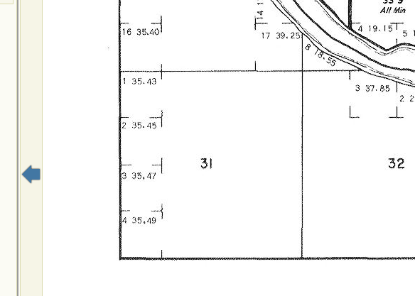
Is production public knowledge yet? I tried to run in on that OCC link you gave me, but I guess it isn’t up… Excited about horizontals being drilled in 6N 1W!
Production numbers are usually four or five months behind first sales. They can be found on the OK Tax site when they are out. I usually start with the bottom hole location and work up hole. The “active” date is the first sales date. So you can tell if the well is online months before actual data is posted.
https://otcportal.tax.ok.gov/gpx/gp_displayPublicPUNListSearchDownload.php
On my lease it states: Lot 3 (35.47); Lot 4 (35.49) containing 70.96 acres, more or less. Does not state gross or net on lease. On DO under property description: 6-5N-1W 31-6N-1W 1247.06 acres. No mention of gross or net on DO. I’m sorry, but I am lost haha! I just don’t want to sign until I know the decimal interest is correct!!!
1 Like
The lease amounts usually have the gross acres of the original patent. You will need the deed or a probate document to tell you the "unidivided x/xx interest in the …) As time goes on, the original grant gets fractionated as it is passed down. Call the operator Division order analyst and ask how many net acres they have for you. If it is close to about 15 acres, then pretty sure you are good to sign. If you don’t have any original documents, then ask the Division Order analyst for the paragraph of the title opinion that refers to your acreage so you can put it in your files for the future.
Okay, got it! Thank you so, so much for your help!
1 Like
Martha, 15 or 1.5 nma?
2 Likes
Finger slipped. I get just a hair under 1.5 acres to get that Decimal Interest. 1.5 gives 0.00025934. 1.4 acres gives 0.00024205, so something in between that sounds about right.
1 Like
For the mass of information that you provide for everyone, it is a wonder that a slipped finger is almost nonexistent.
Tied to whether or not I have had enough coffee or tea before I start working.