Sorry, I should have put anything going on with my property, E 1/2 of the NE 1/4 of the NE 1/4 of Section 14, Block 7. 20 acres. Reeves County. I hope I wrote this right this time. Thank you William Sweeney
William…Nothing going on in the area of your surface acreage. Your acreage is in the area of the red check mark.
GIS map of Reeves County Section 14/Block 7:
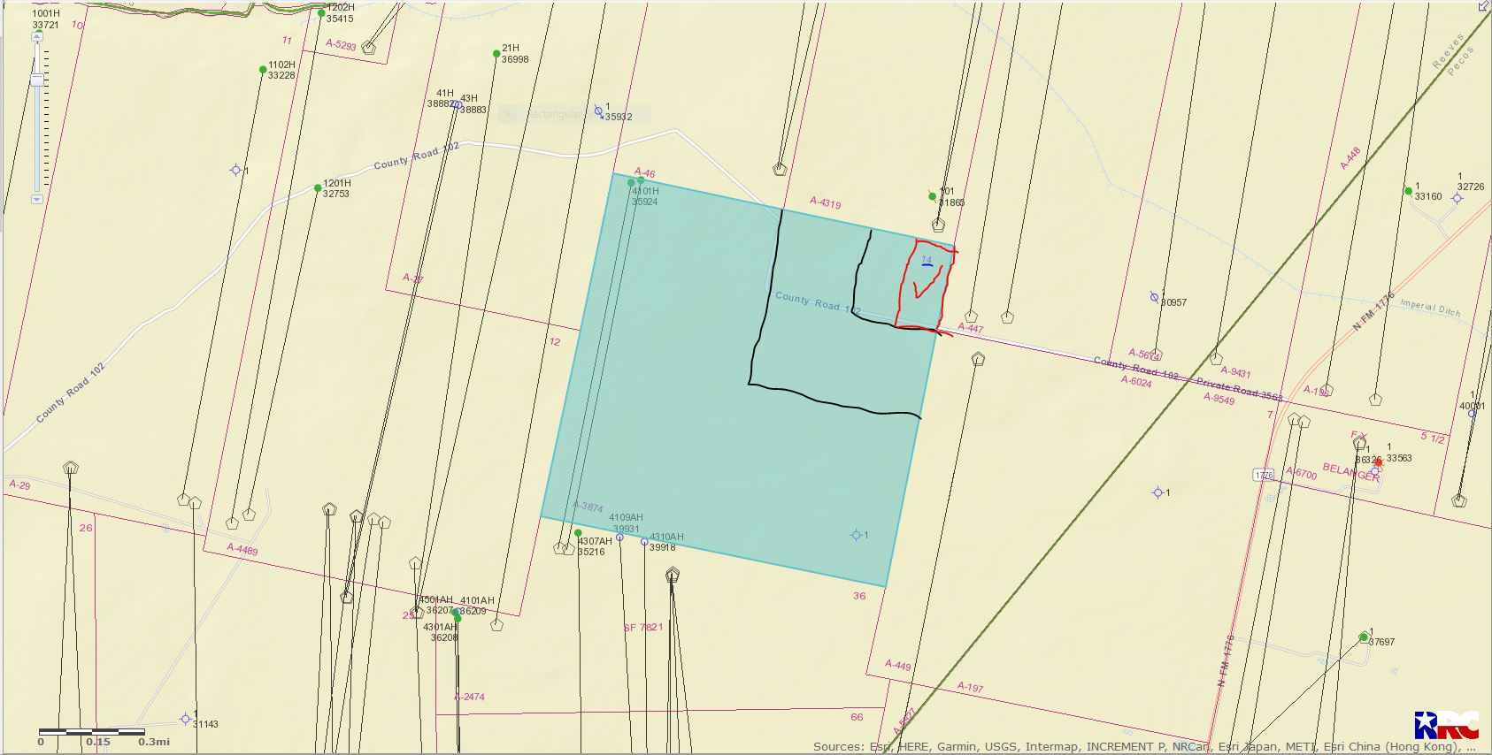
LEFT CLICK ON MAP TO ENLARGE
Thank you Mr. Liles, you have helped before with this question. Wasn’t able to pay a lot of attention lately. Really need to educate myself now. I saw that I think it’s called the RSS survey. Could you post that for me? I think I would be able to see what’s on the land without asking the same dumb questions. Thank you William Sweeney.
William, I’m not sure what the RSS Survey is?
William
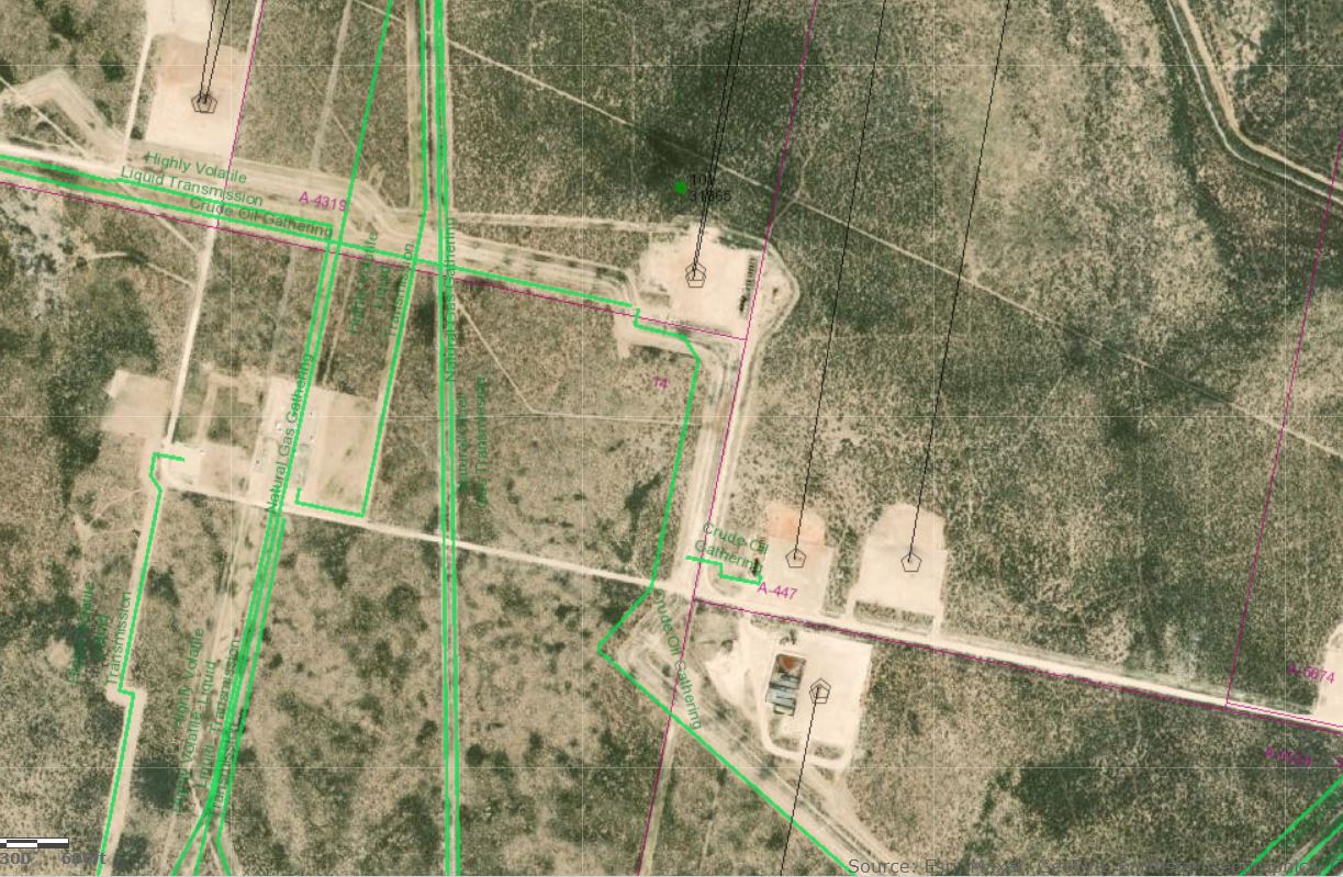
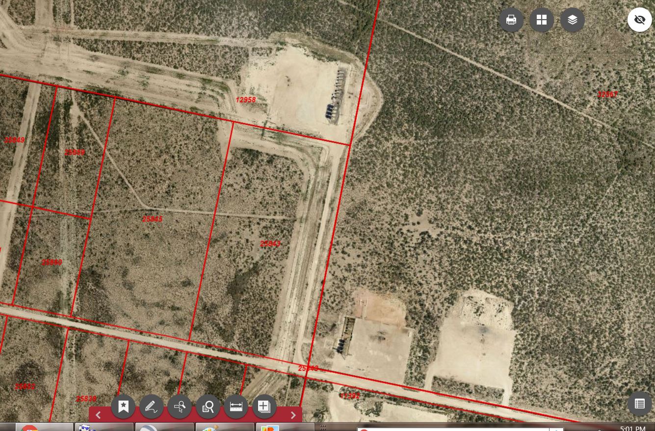
Attaching a couple of aerials showing your 20 acres. The first one is from Texas Railroad Commission, and is the same map Clint sent you earlier but showing the surface view. The second map is from the Reeves County Appraisal District. Your tract is shown there as Account 25843.
From these maps it looks like there is a road extending across the east side of your property from the county road that your property fronts on back to a production location that is in the Section joining you on the north. It looks like there may now be a tank battery there, possibly serving several wells. The wells originally drilled from that pad north of your property were called the State Skinwalker 2-8 1H and 1HX. They were drilled by Jagged Peak Energy in 2016 or 17 but are now operated by Parsley Energy.
The permit plat for the 1HX well indicates the State Skinwalker unit didn’t include your acreage. You will need to verify any of this you weren’t aware of, but if the mineral interest on your acreage wasn’t part of that unit, and you own the full surface interest but didn’t grant a road easement to access that production site, you probably will want to contact Parsley about it.
On the RRC map the green line crossing the east side of your property, running parallel to that entry road, is a crude gathering line operated by Orxy. I’m assuming you were aware of that easement.
If you have a problem seeing the map from the appraisal district go to their site reevescad.org and you should be able to pull up your account.
Dusty, I sent you an email, as a reply to yours. Did you receive them? I am not sure if I can respond this way to you. How would I find Parsley Energy information? Would Mr. Wade Caldwell handle something like this? Thank you again. Billy Sweeney
Mr. Liles, it was the RRC map I was thinking of. Thank you for everything. Billy Sweeney.
Dusty, thank you for the information. I greatly appreciate your help. I was wondering, is that my 20 acres and only mine in the red square acct.25843? If so, both of those roads are on my property, without my knowledge. Should I get a survey of whole 20 acres, with aerial photographs? Would I contact Mr. Caldwell if I have problems with Parsley Energy and where would I find their information? Thank you again for everything. Billy Sweeney
Bill
Didn’t see an email but maybe I’m not looking in the right place.
Here is a link to contact information for Parsley Energy. I’d start by trying to call their Midland office and probably try to talk with someone in their land or right of way department.
http://www.parsleyenergy.com/contact/default.aspx
I haven’t dealt with Wade Caldwell but have always heard good things from people who have. But before contacting him, or any attorney, I’d try to figure out if I really had a legal problem.
Each of those aerial maps shows the location of your eastern boundary a little differently relative to the location of that entry road. The RRC map appears to show most of the road right on the boundary, or just east of it, but the Reeves County, Texas CAD aerial seems to show the full road within the boundary of your tract. Keep in mind though that those aerials aren’t the same as a survey so it is very possible that road is on the adjoining property to the east and isn’t encroaching on your tract, just near it.
Do you have a survey of your property or know if that east boundary is fenced? I’m assuming you aren’t in that area but if you know someone who is maybe they could go by and tell you what they see on the ground.
If you can get in touch with Parsley and they will give you an email address where you can send them information you could forward them that Reeves County, Texas CAD aerial and reference the well name to help pinpoint the location you are talking about. See what they can tell you and then decide if something else is needed.
1 Like
Thank Dusty, the email was returned as undeliverable. So I guess that too protects people. Unfortunately I am not in the area, or know anyone who is. I never had a proper survey. Just drawings about where the boundaries are. I haven’t been out there in years myself probably 4 years. How would I obtain a Reeves County, Texas CAD aerial image? Is there a Section on here survey advertising? Unfortunately the last 4 years, I was really able to concentrate on my property, but that’s over. I am just familiarizing myself with website, and the RRC public viewer, thank you for the site. Thank you very much for everything. I do appreciate it. Billy Sweeney
Dusty, I found the Reeves County, Texas CAD, it had popped up when I was looking for the site you sent. Thanks Billy Sweeney
This topic was automatically closed after 90 days. New replies are no longer allowed.