F100 owner: That 16 inch Primexx gas line that passed through my property goes over to Hwy 285, splits and one line goes to the WAHA complex at Coyanosa, the other goes to that new Energen 350 Million CFD gas plant on the east side of 285 where Reeves and Pecos counties meet. Apache will be putting in at least 8 more gas gathering and transport lines from their fields on the west side of FM2903 and northwest of Toya to the gathering hub at WAHA near Coyanosa.
Nobody likes getting a Love Note from an Attorney…
The solar company and surface owner do not have the right to make the minerals subservient to the surface use. For this reason, the solar company could contract with the mineral owner to agree that the solar use dominates over the minerals in exchange for some compensation to the mineral owner. This is mostly possible where there are one or two mineral owners—for example, each owns 1/2 of 320 acres = 160 NMA. If there are many mineral owners, then it is difficult to get them all to agree. If you owned 100% minerals in 10 acres, then it might be reasonable to agree to make the surface use dominant as it would be easier to have an alternative drillsite. With large acreage, this could be more risky for mineral development. Or you could agree as long as multiple drillsites were preserved by binding contractual agreement of both the surface and solar company and then you should consult with the oil company lessee to confirm the best sites.
1 Like
If a company owes you monies for seismic testing on your land that you agreed to a small amount of money. Supposed to have paid owners in July, contacted them and they said Sept or Oct. Called about 4 times and cannot get them to even answer. Left messages but no return calls. How would a person go about getting the money they are owed? Any and all help is appreciated. Thanks in advance.
Charles Emery Tooke III,
Thanks for the information. Will try that…hope it works.
Appreciated.
Ol’ Lawrence thanks for the information - always a learning experience. I know we are awaiting pipeline work and central processing setup for the work on our property just southwest of Toyah. Not sure where they are planning to connect these wells (provided they become wells). We did get a video of them flaring our wellhead. That was impressive.
Charles Emery Tooke III,
I would like a love note with some money in it from the Seismic company. Would be a great Christmas present.
Phillips 66, Enbridge to build pipeline from Crane, Loving, Reeves, Winkler
Houston-based Phillips 66 and Calgary-based Enbridge said Dec. 11 they will partner to build a crude oil pipeline from West Texas to destination markets in Corpus Christi, Houston, and Freeport. The Gray Oak pipeline will connect to more than three million barrels per day of refining capacity and multiple dock facilities capable of crude oil exports. Origination stations will be located in Crane, Loving, Reeves, and Winkler counties in West Texas. Initial throughput capacity will be 385,000 b/d with operation beginning in late 2019.
I count at least 11 natural gas liquids and crude oil pipelines being built from West Texas (west of Odessa/Midland) to the Gulf Coast. That will probably double when the big exploration companies move through North and South Culberson County into Southeastern Hudspeth County to accommodate the 25,000 horizontal wells to be drilled in that area. There’s going to be about 12,000 to 15,000 such wells in Reeves County alone.
Louise, you should have been paid before they entered your property.
Find your paperwork and call an attorney.
Happy to say that I now have BPP Acquisition LLC and Centennial both bidding to lease our mineral acres. The latest offer was $6,750.00/acre signing bonus. Patience really can be a virtue.
Thank You So Much!
By the way, Reeves County surface/mineral rights owners: Merry Christmas!
Did some prowling over Christmas. On both sides of Hwy 17 south out of Pecos to Balmorhea, especially from County Road 329 north to FM 869 and even further north to County Road 121, then west over FM 2903 paralleling it for about 10 miles west of 2903 from Balmorhea to Toyah and northwest of Toyah in the eastern edge of Culberson County…there’s about 750 sections of land that are scheduled to be drilled up over the next couple of years. About 8000 new horizontal wells are projected to be drilled on those 750 sections. I count about 40 recompressor station sites being built and, at present, 16 major gas and oil gathering pipelines being constructed…with more to come.
So…it looks like it’s gonna be a Very Happy New Year.
2 years remains on our lease on Block 58 Sections 15-16 12 miles North of Toyah. Sure hope we get some action in that time frame, or get released in 2 years.
Happy New Year to you and thanks for your input in Reeves County on this site.
Wulfgen, Primexx and Apache corporations are very active in the area you described. West of Hwy 17, north of Interstate 10 there are two 4 wells recently drilled by Primexx. The latest one they are now fracking is at the intersection of County Road 311 and FM 3334 about 2 miles west of Highway 17. But, Apache has a couple of new wells on the west side of County Road 315 a couple of miles south of FM 3334, north of Interstate 10. They are both moving towards FM 2903 and towards Toyah.
That whole area has THOUSANDS of wells projected to be drilled in the next year by Primexx, Apache, Centennial, Oxy, Diamondback, Shell Western, BHP Billington, and a bunch of others moving into the area. Don’t be surprised to suddenly get multiple offers to lease or sell minerals.
My family has approximately 103 NMA out of the East half of Section 59 Block 13 G&GN RR Co. We are currently not leased but interested in leasing. Can anyone tell me what company has most of this area leased and how production is going in this area? This property is located North of I-10 and West of Hwy 17. Thanks for any information about this area or potential oil companies leasing in this area.
Thanks for information! Sounds like Reeves County is booming!
Price of WTI oil to rise to $105/bbl…so Christian Hamer says:
oilprice105
The second reason is the Iranian revolution 2.0.
Anti-government forces are out on the street having rallies in the biggest protest wave we’ve seen since the 2009 Green Revolution. People are getting killed and others are being hauled off to dark holes by the Revolutionary Guard.
During the last mass Iranian protests, oil went from $40 in the spring of 2009 to $80 a year later.
Iranians are young, 25 years old on average, born 14 years after the 1979 Islamic takeover. They care less about religious fundamentalism than they do about getting a job and feeding their families.
It is difficult to determine how far the protests will spread and what will come of it. History tells us that the rot inside dictatorships is well covered by paint and varnish. It looks good until someone pokes a hole in it.
////////////////////////////////////////////////////
I think the guy is right…WTI crude will jump to over $100/bbl within the next 60 days…which is GOOD for the ‘boom’ in the Delaware Basin. There will be more rigs running here in Reeves, Loving, Culberson, and Hudspeth Counties than in all the rest of the world soon.
Good Morning,
I have received a couple offers on my family’s 3.33 mineral acres in SE/4 of Section 136, Block 13. One of the Landman had told me that they are already drilling our mineral acres. We haven’t yet signed a lease to anyone. Is this normal? Can they drill without a signed lease?
Seems illegal/unethical to me.
Thanks for any advice.
Sharon Rutan
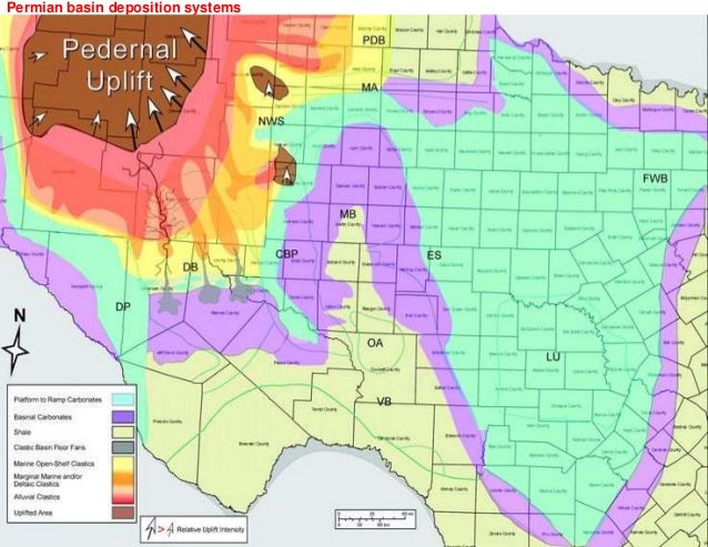
Keep in mind this map is NOT that accurate. The red and grey and bright yellow areas should be much bigger and pronounced in Reeves, Culberson, Jeff Davis, and Hudspeth counties. There are 7 lesser faults that correspond with major river tributaries to the Pecos River fault that connects with the Rio Grande Rift near Del Rio. Those grey ‘fans’ are where ancient rivers emptied into the inland sea basin millions of years ago and are the source for the Trans-Pecos Alluvial soils in Reeves, Jeff Davis, Culberson, and Hudspeth counties where the stacked shale plays are concentrated.
Toyah Creek, Cherry Creek, Nine Mile Draw, Delaware River, Salt Creek—all are secondary crustal seismic faults connected to the Pecos River fault. The rivers followed those faults and drained the entire Delaware basin into the Pecos River fault, transporting the flow to the Rio Grande River along the Rio Grande Rift.
Those many seismic faults cause schisms in the anticlines of the stacked shale plays of the area and pinched out concentrations of hydrocarbons near the upthrusts of the area from the Pecos River west to Sierra Blanca in Hudspeth County.
This structure (Delaware basin) is a HUGE reservoir of many different producible zones for natural gas and oil. But, you must understand, there are THREE more such basin structures across the Rio Grande Rift in Mexico that can be developed as well.
Ty J Wood, Attorney. He has extensive O/G background in Texas and New Mexico. 325-728-8400. Our family has used him for numerous O/G leases/ROWs and solar leases.