Yes we did. The old easement gave them x feet on both sides of the 6 inch line. It also stipulated that if they needed to place larger line in the future that they would pay for the extra footage in length and width to maintain the same distance from center as the original line for repair or maintenance access. That offered 2000 I said 8000 we ended up at 4500. Probably could have gotten more but wasn’t sure where I legally stood?
The 4500 was the pipeline row. Nothing has been signed as to the mineral rights. I own the surface acres. So whoever owns the 3/4 share of the minerals signs with Obenco. They can or can’t get on my property?
Whoever owns the other 3/4 minerals has the right to sign a lease which gives them the right to enter our property regardless if you sign a lease or not, BUT if you don’t then are forced into a back-in situation which means they can go ahead and drill, you would own 25% of the working interest, which includes all cost of the well and again, BUT, you can’t recoup your money or receive any royalties until they have received back the cost of drilling the well plus 3x the amount and it falls on you to prove when that is. The lease is the best way to go if you are not an operator or don’t have the funds to invest in this. It’s a big gamble which is why people lease. It throws all the liability on the operator. Speaking of liabilities. This is another reason to get an attorney in order to make sure they have the liabilities covered on your property. You need to get a surface use agreement in place that addresses all the issues with safety, liability, traffic, trash, 24 hr operations, how long they can stay after they have completed drilling, and a big one is damages. Do you live on the property?
No we live in Athens. The property is 8 or 9 miles out north of town. So if the 3/4 people sign they can put a well on my land without my permission? That’s crazy.
Yes, it’s the law. In the state of Texas if the minerals are severed from the surface the mineral owner has as much right to produce their minerals as it is the dominant estate. I can send you the name of an attorney to use if you like. It’s good then that you don’t live there but it’s at least possible to get a surface use agreement done so you can protect it. Also know that in the future if the well doesn’t work out instead of plugging it, it might be able to be used as a salt water disposal well and the surface owner gets all the profit from that. Not the mineral owner. Also if they have to pay you for a subsurface easement if they directional drill. When they invade your subsurface drilling under it and through it they must pay you for a subsurface easement. That belongs to the surface owner as well. Let me know on the attorney. You can call me if you like as well. 432-352-4510
Definitely interested in the attorney sounds like a good investment thanks for the info.
I will get back with you with name and number.
How many feet will the pipeline cross your property? Do you own the full minerals to your property? 58 acres?
Just wondering we are near there.
I don’t remember the exact running feet. I would guess it to be approximately 350 to 450. But realize they already had x feet of ROW from a lease back in the late 80’s. The 4500 was to add a few feet in width to the existing lease with no addition to the overall running length.
Where is your property?
Off of Hwy 19 north of Athens. It was regarding a new pipeline. Thank you for the reply.
That does help me have an idea on the footage cost though, this would have been a 30 ft wide easement, but much longer.
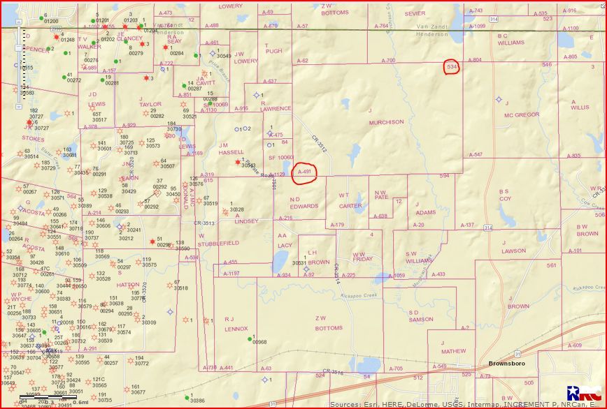
I have 30 acres of minerals in the John Murchison, how would I check to see if it’s part of a unit? I was contacted about leasing 3 plus years ago, just before the bottom fell out of the petroleum market but haven’t heard back since.
Real Cajun,
Give US a little more to work with, like a Section or Abstract Number.
Thanks,
Clint Liles
CAJUN, I ASSURE YOU, YOU’RE NOT GOING TO FIND ANY CRAWFISH IN HEREFORD, TEXAS UNLESS YOU BROUGHT THEM WITH YOU…SUGAR BEETS, COTTON, WHEAT AND MILO,YES

Clint,
Thanks for the quick response. I don’t have the paperwork here, it’s in the safety deposit box but I found a copy of the map with the area mark off (see attachment). I own 30 acres of the 103 acres shown on the map. The person that contacted me in 2014 worked for a company called Monarch and he said he was leasing for a company called Hillcreek.
Regards,
Barton Migues
458-Texasmineralrights.pdf (863 KB)
To my knowledge there has been no new drilling activity in this area for some time. And if there was and it included your acreage in the unit, you would definitely have been contacted since operators want to have as little unleased acreage as possible in any drilling unit.
Cajun,
Rock Man is correct about this old oilfield to the West of your minerals. This is about 25 miles from my home and is known as the Opelika Oil Field. There is a mixture of Rodessa, Travis Peak and Cotton Valley vertical wells in this old oil field. To the Southeast of your minerals about 6 miles Chesapeake has drilled the Ned #1H into the Goodland Lime formation…Completion Report showed 275 BOPD/218,000 Cubic Feet of Gas Per Day.
GIS Map of Henderson County A-491/Section 534/John Murchison Survey:
CLICK ON MAP TO ENLARGE