Michelle,
What is the lease name? I can look it up on RRC to see if they are still producing.
Michelle,
What is the lease name? I can look it up on RRC to see if they are still producing.
I have minerals in the W/2 of a section. There is a well in the E/2. Also own minerals in some of the adjacent sections. Is it unusual to not be receiving royalties from a producing well in the same section?
Willard, please quit advertising your lease request for Dawson County on the Howard County group discussion. I note from your profile page that you are posting it in other counties as well. Best of luck in leasing, but please I would request that you limit your post here to Howard County activity.
Could someone tell me why I have similar but different undivided mineral interest stated by 1st Co lease, 2nd Co. leased my 2-year extended lease and now 3rd Co. who I am also seeing a smaller amount. As I am told I will get a division order soon, would like to clear this up. Thank you for your response.
Kay, it is impossible to answer your question without examining the complete title. Oil companies have title examiners and they will use the interests as determined by their examiner. The only way to change their mind is to have an independent examination of the title by your attorney to convince their examiner where he made a mistake.
Hello Kay,
Take Dave’s advice. I ran across a similar situation as yours and ended up having my own abstract work done by a certified professional landman with a lot of experience in research. It cost me a small fortune, but it is well worth the trouble.
Good luck!
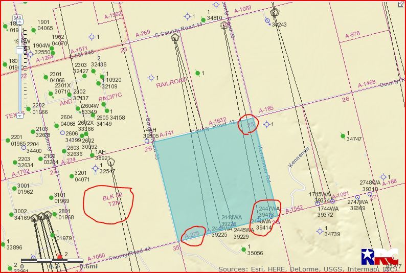
I am new to this site and have been reading a lot of comments. I have a little over 7 acres of mineral rights leased on E/2 of Section 25, Block 32-T2N. S&M has 2 permits. Does anyone know if drilling has started or where they are in the process? Don’t know much about S&M.
Thanks for any help.
Danny, I just tried pulling up the permitted locations/wells for the eastern half of Section 25 and apparently the RR Commission has the GIS Mapping Viewer shut down for maintenance. It may be tomorrow before I can check on information for you. Do you have the API #'s of the 2 approved locations in that area?
Danny - one of the wells has been spud and surface casing set, but the big rig hasn’t moved in to do the deep drilling yet from what I can find. I believe you actually have three permits that include the tract you describe. SM Energy is the best operator in your area in my opinion.
Danny, Marcus T is right. Well 39414 was spud on 01/30/2018.
Link to approved permit for well 39414 showing spud date:
GIS Map of Howard County Section 25/A-275/Block 32 T2N:
Clint Liles
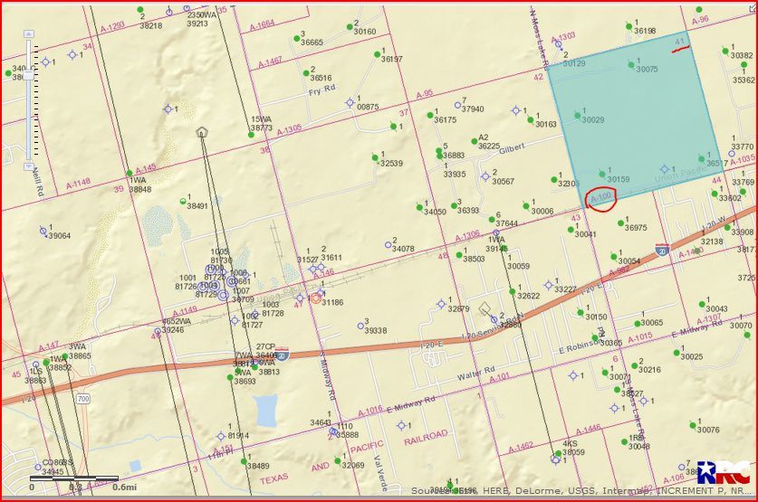
Good Morning Becky. At this time I don’t see any activity in your immediate area. SM Energy is very busy west and northwest of Section 41. They have 2 new permits as of February 21, 2018 in the northern edge of the City of Big Springs, I don’t see any activity by Grenadier at this time. SM Energy has some good wells to the west of Section 41.
GIS Map of Howard County Section 41/A-100/Block 32 T1N & surrounding area:
CLICK ON MAP TO ENLARGEThe 2 API #'s are 22739229 and 22739414.
I am not sure if the permit to the west # 22739229 is on my side of E2.
Is there any activity happening in Section 3, Block 33, Township 1 South?
Thanks
I see where 4 permits (API 227-38735/38736/38890/38891) were approved for horizontal wells to extend into Section 3 in July and November 2016 by OXY USA, Inc. As far as I can tell, only one of those wells is producing at this time and that is well 38736.
Link to Production Data on well 38736:
GIS Map of Howard County Section 3/Block 33 Township 1 South/A-359:
CLICK ON MAP TO ENLARGE
Clint Liles
Thank you. I don’t quite understand if this relates to our minerals, sorry to be such a dummy on this.
Judy, do you own all the minerals in this Section 3?
Clint Liles
No, my siblings and I own 3/32 of the mineral acres, which I was told is 22.5 net mineral acres.
Judy, if you own 3/32 of the minerals, that would be 60 net mineral acres. A Section has 640 acres. 3/32 x 640 = 60. Unless you already have all of the relevant documents, then you need a landman or attorney to secure all of the documents at the courthouse. There are some online services that may help as well if you don’t have to go very far back in time.
Thank you.
Any suggestions for a CPA to talk with about tax consequences when selling mineral rights? My mineral rights are in Howard County, but I live in San Angelo. I do go to Big Spring periodically.