Completion Report
September 24, 2014
October 06, 2014
October 14, 2014
October 20, 2014
October 30, 2014
Hello Mr. Clint Liles:
I am a novice in the oil/gas business and was checking out the “Mineral Rights Forum” site and noticed your updates. Since you seem to be extremely knowledgeable, I would like to ask you a question (hopefully, the question is not too ridiculous), and I hope you can either answer or steer in the right direction. Question: Is there any inexpensive way to find out if your land is being drilled upon from a distant well that is less than a mile away? Background information: I signed a lease with an oil company that pigeonholed me via Rule 37. While the Commission was still out with a ruling, the lease offer was made. Fast forward: Today this company has an active pump that is not too far from my property, and before signing the lease agreement, the pump was not there. When I asked the landman if my property was involved in this well pool, his answer was “no.” Thus, how can one determine whether the answer “no” is correct? Thanks for your consideration.
Hi Brenda,
That would be a hard question for me to answer. I suggest you present this question to the Railroad Commission folks in Austin. Use this link to send them an email with your question. I’ve always gotten a fast response and have been satisfied with the answers they give. Good luck with your minerals and maybe I will be posting a well for you someday in the future. What is your Abstract, Section, and Block #?
(use the one that says ‘help desk’)
This is the information that I have on file: My property is 96.67 acres and situated in the Joseph Thompson Survey, A-42, in Colorado County, Texas. Based on past information on the Railroad Commission Online System, Form W-1: Review, the Status no. is 765200. Note: The Section and Block fields are blank. However, the Abstract number is 42. I hope this is enough information for future well postings. Importantly, I will contact the Railroad Commission in reference to my question. Thank you so very much.
Brenda,
I am assuming you are speaking about the approved drilling permit for well API 089-32700.
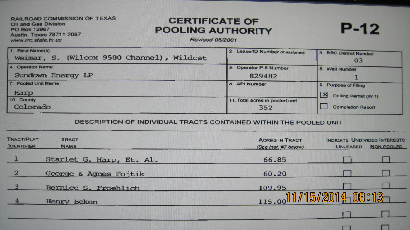
The P-12 (pooling order) at the bottom of the permit states that this unit/lease consists of 352.00 acres. Since there are 640 +/- acres in a Section, your 96.67 acres are possibly in another area of this Section.
Picture of the P-12 (pooling order):
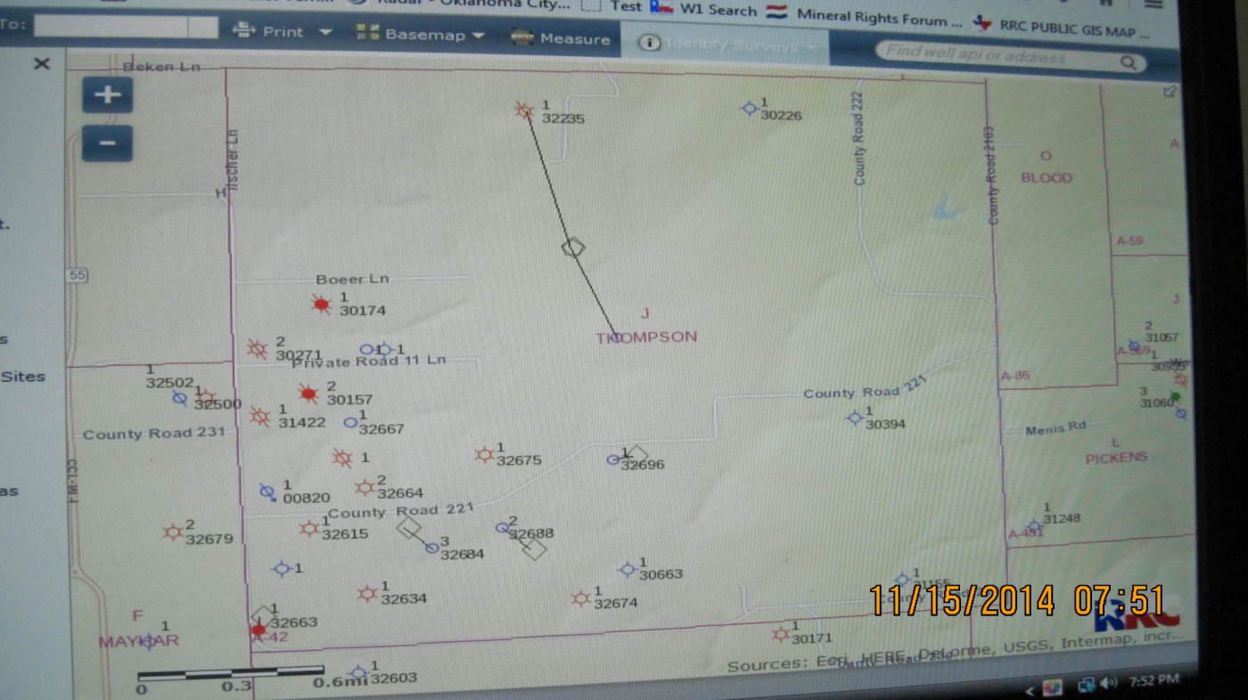
On the GIS Map of Colorado County A-42 I am about to post, the well API 089-32700 does not show up but it should be in the area of the H on the word Thompson:
Clint Liles
Brenda,
I've posted the picture of the P-12 3 times and I can't get it to stick for some reason. The P-12 states that 4 different parties have minerals in this unit/lease/352.00 acres.
Scarlet Harp 66.85 acres
G. & A. Fojtik 60.20 acres
Bernice Froehlich 109.95 acres
Henry Beken 115.00 acres
Clint Liles
Wow! This is good information, and the map is very familiar. I actually recognize the turf, and it looks like the line is either on my property or very close to it. The land has not been surveyed in years, actually purchased in 1873. Now, the third generation is getting involved. I think it will be wise for us to get the land surveyed, and go from there. Do you know of any honest surveyors? Unfortunately, I do not trust the oil company that tried to steal (rule 37) our resources without compensation. Importantly, I want you to know that I truly appreciate the information you provided and appreciate any further opinions related to this matter. Thank you very much!
Good Morning Brenda,
Since I don’t live in the area I don’t know any surveyors in or around Colorado County. Possibly one of the Colorado County Group can advise you on a good surveyor.
And don’t ever trust one of these oil companies. They are not in business to make you money.
Good luck with your minerals area.
Clint Liles

November 18, 2014
Completion Reports
December 12, 2014
January 23, 2015
March 06, 2015
March 12, 2015
March 30, 2015