You might want to read the postings on the forum regarding Continental’s SPRINGBOARD play. Use the magnifying glass on the top right. Personally, I think $10,000/ac is too low for that section.
1 Like
I agree on the structure. I was just answering the question about activity in each section.
It would seem that the basis/differential blowout is going to impact the already slow development and low interest in the pure gas portion of the play.
I anticipate that the costs on the deep deep wells there would have to come down to around full cycle costs (leasehold, F&D and operating) of $0.75/mcf or less to compete with Haynesville, Utica/Marcellus, etc.
With the excess gas in the Permian, it also seems like the decrease in mid-con realized gas price might get extended as gas-on-gas competition probably won’t ease over the next few years. Let’s pray for some robust LNG exports and relief in Chinese tariffs on LNG.
Not sure how operators can break even in the deep sections at this time.
Maybe the northeast corner of the Section is shallow enough that it has some liquid content, but it also appears to be highly faulted in and around there.
Thoughts?
which section or township?
The Sections along the edge of 5N-7W (1, 2, 12 and maybe 13), I think anything that’s more than a Section or two in from the eastern or northern edge are going to be in the area where it really starts to plunge into that deep abyss along the uplift and will be mostly if not completely dry gas and uneconomic.
I’m not in front of my computer now so don’t have any of my logs, maps, etc. in front of me.
Have you seen a widening of the differentials across your Arkoma and Stack/SCOOP average? Not sure if it’s mostly on Oneok’s pipelines or if differentials expanded on the other pipelines as well.
Agree, 1, 2, 12, 13, 24, 25, 36 “about” Dry, deep gas on the west side of that thrust line for Woodford. But they might pick up a different shallower shale if they can get it in the right window. Just posted a nice generic Woodford map in the Woodford Shale play. Shows that thrust.
I have some nice Hoxbar in 6N-8W.
Haven’t had time to look at my differentials. Good idea. Not, that we can do anything about it, but good to keep an eye on it. Does affect the “market” value. Also probably depends upon who is hedged and who is not, LOE costs, sweet vs sour, etc.
I have a bunch of geo maps I can add as well.
Thanks Jeffrey and Martha for your in-depth analysis!
How does Section 21, Township 5 North, Range 7 West look for Woodford and intermediate & deeper depths? Our leases for approximately 230 NMAs are held by Gulfport for those depths. The Unit well is limited by a 100’ depth clause. FYI, the Marshall Craddock vertical well has been plugged.
Very, very deep
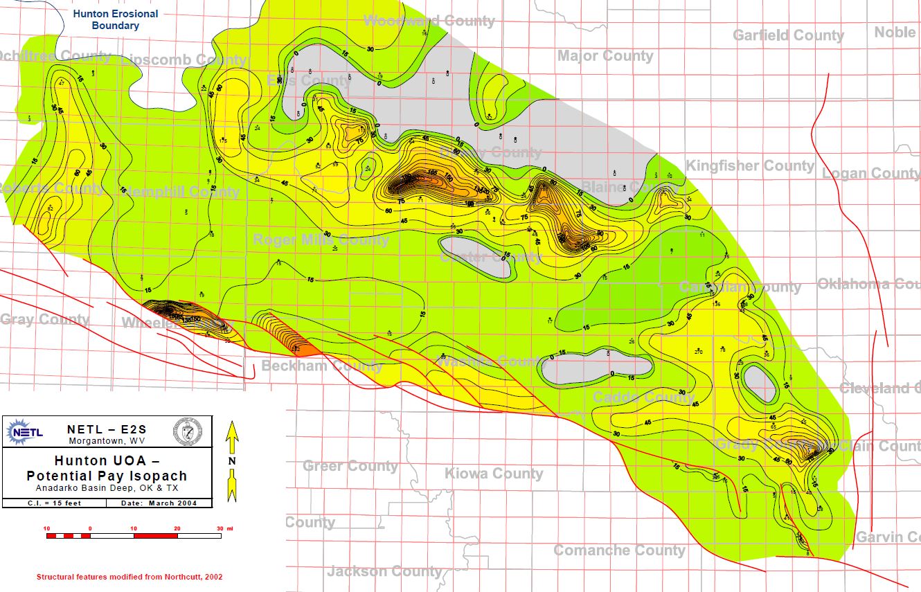
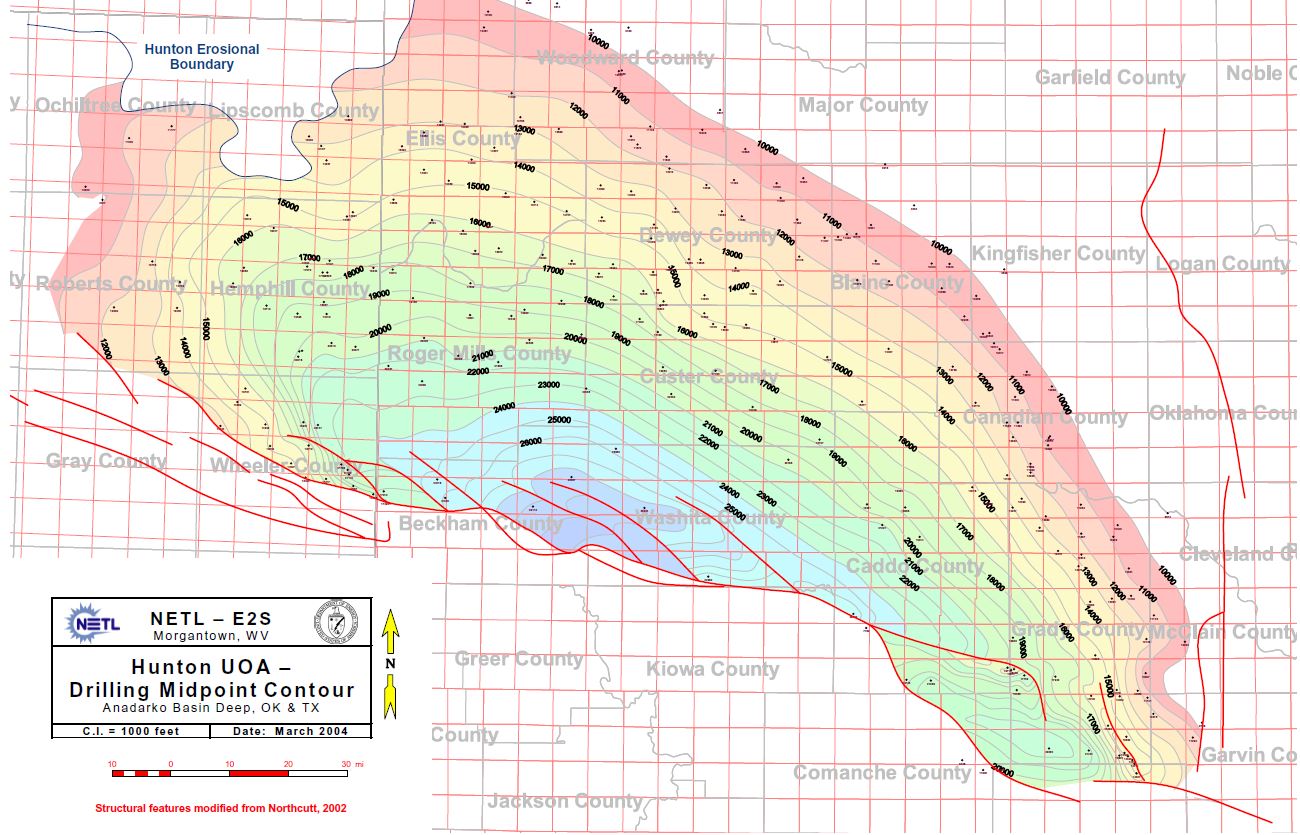
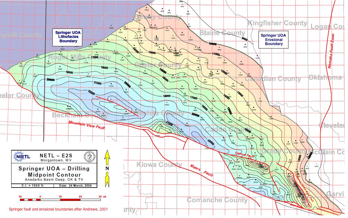
The 2004 NETL Study has some great maps for the Springer, Hunton, Miss, etc., along with cross sections.
This is the study that many of the companies reference when distinguishing the normal/over pressure line.
Hunton Pay Isopach:
Hunton Mid Point Drilling Contours:
Springer Mid Point Drilling:
1 Like
Here’s Don’s great chart.
Green = Units in Progress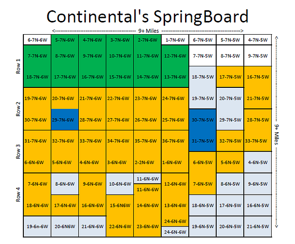
Orange = Planned Units
Light Blue = Non-Op Units or Not Planned
Blue = Developed Units
1 Like
And everything is in Range 6 West, basically because of the way the basin dips into the thrust.
Thanks for all the great charts and information, Jeffrey.
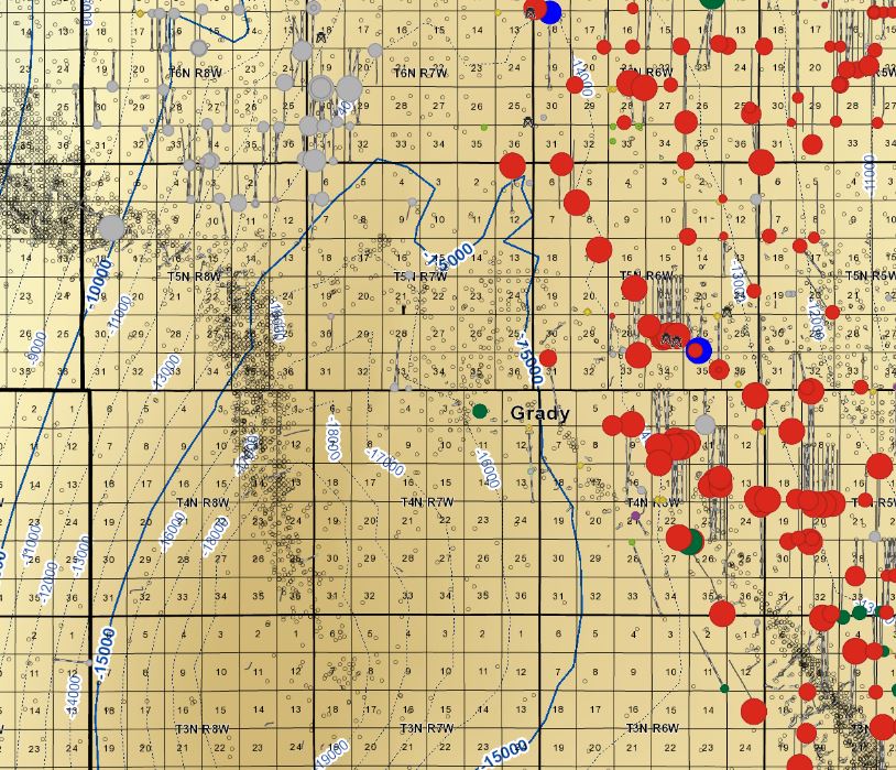
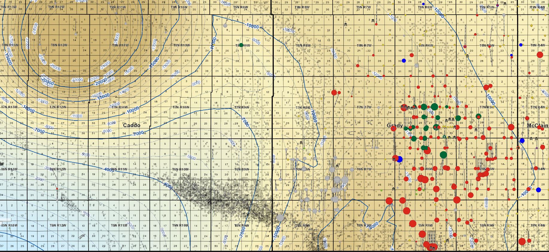
I found particularly interesting the Grady County section map showing a lot of the wells up to 6-6 and 6-5.
I have noticed some comments concerning sections farther north like these comments on 8-7 and 9-7:
Has anyone seen any movement on 26-8N-7W? Drilling was set to start on 10/21/18.
Looks like some activity in Section 9 9N 7W.
Do you have a Grady County section map showing the wells farther north like in 7-6, 7-5, 7-7, 8-7, and 9-7?
Thanks in advance.
Thanks Jeffrey.
That line seems to continue on up Grady County.
On one side it’s great… on the other side not good at all.
Maybe they will find something deeper some day on the “bad” side.
Do you have the original link for those Springer and Hunton maps? I found the Mississippian, but can’t find these. I wanted to post in the Anadarko Basin Category so everyone can see them. They are quite helpful.
I wonder what the blue lines and the dotted lines indicate. Depth?
Looks like Unit already has, the Schenk Trust in 17-6-8 at 2366 bopd!
The Schenk is in the Hoxbar.
I can post them over there…if I don’t get to it tonight or forget, just ping me.
I’m trying to see why they don’t have a Woodford map.
I can’t recall if I found this via the USGS/US National Energy Map or if I paid/downloaded it from AAPG.
Hobax has potential in and around where UNIT is operating.
Also note that the depth and to a degree the thermal maturity of the various formations, Woodford, Miss, etc., arch to a degree to the NW. There’s an interplay between depth and other formation characteristics, such as thickness, porosity, etc.