# What is this installation? and who built it?
**URL:** https://www.mineralrightsforum.com/t/what-is-this-installation-and-who-built-it/19005
**Category:** Karnes County, TX
**Created:** [December 29, 2012, 3:53pm UTC](https://www.mineralrightsforum.com/t/what-is-this-installation-and-who-built-it/19005 "2012-12-29T15:53:16Z")
**Posts on this page:** 11
**Page:** 1
### Author:  [@Terry\_Nance1](https://www.mineralrightsforum.com/u/Terry_Nance1)
#### Post date: [December 29, 2012, 3:53pm UTC](https://www.mineralrightsforum.com/t/what-is-this-installation-and-who-built-it/19005/1 "2012-12-29T15:53:16Z")
I own a ranch in the northern part of Karnes County at the junction of CR 289 and CR 277. Just down the CR 277 which turns into CR 212 out in the middle of nowhere is this new installation. Does anyone know what this is and who owns it? There are no signs by the gate.
---
### Author:  [@nicole\_donner\_bishop](https://www.mineralrightsforum.com/u/nicole_donner_bishop)
#### Post date: [December 29, 2012, 4:50pm UTC](https://www.mineralrightsforum.com/t/what-is-this-installation-and-who-built-it/19005/2 "2012-12-29T16:50:11Z")
No… but when you find out or if you find out could you let us know? I have property out there too and I live in MS! Thank you very much for sharing. I will make calls on Monday!
---
### Author:  [@nicole\_donner\_bishop](https://www.mineralrightsforum.com/u/nicole_donner_bishop)
#### Post date: [December 29, 2012, 4:51pm UTC](https://www.mineralrightsforum.com/t/what-is-this-installation-and-who-built-it/19005/3 "2012-12-29T16:51:24Z")
Is there any markings on the trucks? Get tag numbers and have the local police run the plates. If you inform the police as to the why they will assist.
---
### Author:  [@Rock\_Man](https://www.mineralrightsforum.com/u/Rock_Man)
#### Post date: [December 29, 2012, 6:25pm UTC](https://www.mineralrightsforum.com/t/what-is-this-installation-and-who-built-it/19005/4 "2012-12-29T18:25:17Z")
Looks like a central production facility where gas is coming in from several wells (through 1-2 pipelines) to have various hydrocarbon liquids stripped out before sending the gas to main gathering system. Liquids going out via separate pipeline.
Surprised as to no signage yet - no secrets here. Figure signs will show up eventually.
Will be a separate operator who has a lot of wells in the area (e.g., Plains, EOG) or a gas gathering company (e.g., Enterprise).
---
### Author:  [@Terry\_Nance1](https://www.mineralrightsforum.com/u/Terry_Nance1)
#### Post date: [December 30, 2012, 3:16pm UTC](https://www.mineralrightsforum.com/t/what-is-this-installation-and-who-built-it/19005/5 "2012-12-30T15:16:42Z")
I think Przzz is correct. The facility is built by a large gas pipeline that was recently built. It also appears that pipelines from several nearby EOG wells (Inverted Bar T and Smith) are connected to it via underground pipelines. It appears EOG is building some more well pads in the area. If I was betting I would say it is an EOG facility.
---
### Author:  [@jdk](https://www.mineralrightsforum.com/u/jdk)
#### Post date: [January 8, 2013, 5:23pm UTC](https://www.mineralrightsforum.com/t/what-is-this-installation-and-who-built-it/19005/6 "2013-01-08T17:23:05Z")
Try API 255-32023, 32024
---
### Author:  [@Terry\_Nance1](https://www.mineralrightsforum.com/u/Terry_Nance1)
#### Post date: [January 8, 2013, 9:40pm UTC](https://www.mineralrightsforum.com/t/what-is-this-installation-and-who-built-it/19005/7 "2013-01-08T21:40:38Z")
jdk; The API numbers you gave refer to Julie 6H & 7H oil wells on the ranch that borders mine. Both of these wells as well as Julie 5H, 8H, and 9H are a stone’s throw from my ranch property line. I can stand on my fence line and throw a rock onto those pads. Plains has a collection facility on that ranch near Julie 1H, but that facility is much, much smaller. The facility I am referring to is several miles to the southeast of these wells.
---
### Author:  [@jdk](https://www.mineralrightsforum.com/u/jdk)
#### Post date: [January 9, 2013, 5:27pm UTC](https://www.mineralrightsforum.com/t/what-is-this-installation-and-who-built-it/19005/8 "2013-01-09T17:27:14Z")
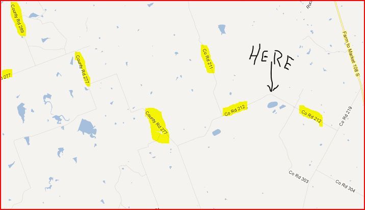
Can you be more specific as to which road these pictures were taken from? Several pad sites show up on Google Earth dated 10/17/2011 but are not complete yet. With the exact location, you can use the Public GIS Map Viewer on the RRC website to get an API number.
---
### Author:  [@Terry\_Nance1](https://www.mineralrightsforum.com/u/Terry_Nance1)
#### Post date: [January 9, 2013, 10:09pm UTC](https://www.mineralrightsforum.com/t/what-is-this-installation-and-who-built-it/19005/9 "2013-01-09T22:09:41Z")
Here is a map I made from Google Maps.
---
### Author:  [@Rock\_Man](https://www.mineralrightsforum.com/u/Rock_Man)
#### Post date: [January 9, 2013, 10:49pm UTC](https://www.mineralrightsforum.com/t/what-is-this-installation-and-who-built-it/19005/10 "2013-01-09T22:49:27Z")
Based on this map, I would say with high degree of certainty that this is an EOG facility. They have multiple wells just south of County Road 212 that are probably routed into this plant.
---
### Author:  [@system](https://www.mineralrightsforum.com/u/system)
#### Post date: [August 15, 2018, 3:01am UTC](https://www.mineralrightsforum.com/t/what-is-this-installation-and-who-built-it/19005/11 "2018-08-15T03:01:14Z")