# Washati multi unit well
**URL:** https://www.mineralrightsforum.com/t/washati-multi-unit-well/64064
**Category:** Washita County, OK
**Created:** [November 27, 2021, 1:17am UTC](https://www.mineralrightsforum.com/t/washati-multi-unit-well/64064 "2021-11-27T01:17:05Z")
**Posts on this page:** 10
**Page:** 1
### Author:  [@Rts74429](https://www.mineralrightsforum.com/u/Rts74429)
#### Post date: [November 27, 2021, 1:17am UTC](https://www.mineralrightsforum.com/t/washati-multi-unit-well/64064/1 "2021-11-27T01:17:05Z")
Just received notification of filing for increased density in section 26 10 19 in washita county by unbridled resources which was four point.
Then I received another one filing for mutiunit horizontal well in 26&35 10 19.
Is the new well in happening 26? Or are we going into 35 from 26 or what is happening?
---
### Author:  [@TODD\_M\_Baker](https://www.mineralrightsforum.com/u/TODD_M_Baker)
#### Post date: [November 27, 2021, 2:52am UTC](https://www.mineralrightsforum.com/t/washati-multi-unit-well/64064/2 "2021-11-27T02:52:28Z")
Yes, the density well for 26 will be a multi unit well with 35.
---
### Author:  [@Rts74429](https://www.mineralrightsforum.com/u/Rts74429)
#### Post date: [November 27, 2021, 12:39pm UTC](https://www.mineralrightsforum.com/t/washati-multi-unit-well/64064/3 "2021-11-27T12:39:24Z")
So if then it is going into two sections 26and35 they will pay royalties two both at 50x50 or how? And are they allocated to produce more per month since it’s multi well?
---
### Author:  [@TODD\_M\_Baker](https://www.mineralrightsforum.com/u/TODD_M_Baker)
#### Post date: [November 27, 2021, 1:05pm UTC](https://www.mineralrightsforum.com/t/washati-multi-unit-well/64064/4 "2021-11-27T13:05:48Z")
Allocations based on footage of perforations in each section versus total perforations. Very, very few wells can ever produce what they are allowed so that is not given much consideration. But ultimate production should be greater due to being able to access hydrocarbons at the section line between the 2 sections that they wouldn’t otherwise be able to if just a single section unit.
---
### Author:  [@Rts74429](https://www.mineralrightsforum.com/u/Rts74429)
#### Post date: [November 27, 2021, 3:28pm UTC](https://www.mineralrightsforum.com/t/washati-multi-unit-well/64064/5 "2021-11-27T15:28:57Z")
Thank you! They said two things in filing one well would be 26,800 ft and then something about 10,000 ft?
---
### Author:  [@Terry\_L\_Shinn](https://www.mineralrightsforum.com/u/Terry_L_Shinn)
#### Post date: [November 27, 2021, 3:52pm UTC](https://www.mineralrightsforum.com/t/washati-multi-unit-well/64064/6 "2021-11-27T15:52:56Z")
Thank you for the information, I am researching sections 26 & 35 in 10N-19W. Can you list the Case CD No. for your document? These files can be viewed @ [https://imaging.occ.ok.gov/imaging/OAP.aspx](https://imaging.occ.ok.gov/imaging/OAP.aspx)
---
### Author:  [@TODD\_M\_Baker](https://www.mineralrightsforum.com/u/TODD_M_Baker)
#### Post date: [November 27, 2021, 7:06pm UTC](https://www.mineralrightsforum.com/t/washati-multi-unit-well/64064/7 "2021-11-27T19:06:11Z")
Rts- 10,000’ horizontal lateral. 26,800’ of hole so approximately 16,800 vertical depth.
---
### Author:  [@Rts74429](https://www.mineralrightsforum.com/u/Rts74429)
#### Post date: [February 14, 2022, 11:51am UTC](https://www.mineralrightsforum.com/t/washati-multi-unit-well/64064/8 "2022-02-14T11:51:12Z")
Did you find anything about the well? I have a paper that says they were approved for the spacing and well but is that a permit to drill or just spacing?
---
### Author:  [@M\_Barnes](https://www.mineralrightsforum.com/u/M_Barnes)
#### Post date: [February 14, 2022, 1:56pm UTC](https://www.mineralrightsforum.com/t/washati-multi-unit-well/64064/9 "2022-02-14T13:56:37Z")
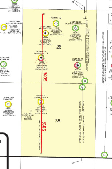
Look in the exhibits from the OCC case 202102618 for planned pathway. The surface location looks like in the the NW4 of section 26 drilling south into 35. The final well survey will determine the exact splits. The well name might be MNR 26X35-10-19 1H
---
### Author:  [@system](https://www.mineralrightsforum.com/u/system)
#### Post date: [February 25, 2022, 1:17am UTC](https://www.mineralrightsforum.com/t/washati-multi-unit-well/64064/10 "2022-02-25T01:17:36Z")
This topic was automatically closed after 90 days. New replies are no longer allowed.