# Wasatch County Utah well-- any information?
**URL:** https://www.mineralrightsforum.com/t/wasatch-county-utah-well-any-information/60021
**Category:** Utah Mineral Rights
**Created:** [January 1, 2021, 6:40pm UTC](https://www.mineralrightsforum.com/t/wasatch-county-utah-well-any-information/60021 "2021-01-01T18:40:49Z")
**Posts on this page:** 8
**Page:** 1
### Author:  [@Jay\_L\_Stone](https://www.mineralrightsforum.com/u/Jay_L_Stone)
#### Post date: [January 1, 2021, 6:40pm UTC](https://www.mineralrightsforum.com/t/wasatch-county-utah-well-any-information/60021/1 "2021-01-01T18:40:49Z")
Does anyone have additional information about the well in Wasatch County, Utah?
API # 4305150003 Well Name: Coleman 1-29-29 Operator: Green River Operating LLC Wildcat SWNE Section 29, Township 2S Range 9W
Thanks, Jay Stone
---
### Author:  [@M\_Barnes](https://www.mineralrightsforum.com/u/M_Barnes)
#### Post date: [January 1, 2021, 9:27pm UTC](https://www.mineralrightsforum.com/t/wasatch-county-utah-well-any-information/60021/2 "2021-01-01T21:27:12Z")
> [@Jay\_L\_Stone](#):
>
> 4305150003
[https://oilgas.ogm.utah.gov/oilgasweb/live-data-search/lds-files/files-lu.xhtml](https://oilgas.ogm.utah.gov/oilgasweb/live-data-search/lds-files/files-lu.xhtml)
---
### Author:  [@Jay\_L\_Stone](https://www.mineralrightsforum.com/u/Jay_L_Stone)
#### Post date: [January 1, 2021, 11:11pm UTC](https://www.mineralrightsforum.com/t/wasatch-county-utah-well-any-information/60021/3 "2021-01-01T23:11:01Z")
Thank you for the response. When checking the state’s website, it indicates the well is confidential. I do not see a way to access the well file. What am I missing? Thanks again.
---
### Author:  [@tracy\_lenz](https://www.mineralrightsforum.com/u/tracy_lenz)
#### Post date: [January 2, 2021, 3:10am UTC](https://www.mineralrightsforum.com/t/wasatch-county-utah-well-any-information/60021/4 "2021-01-02T03:10:36Z")
I’ve been poking around Wasatch/Duchesne Counties lately. Next time I’m at my computer (vs my phone) I’ll take a look and let you know. Remind me here if I forget!
---
### Author:  [@M\_Barnes](https://www.mineralrightsforum.com/u/M_Barnes)
#### Post date: [January 2, 2021, 1:46pm UTC](https://www.mineralrightsforum.com/t/wasatch-county-utah-well-any-information/60021/5 "2021-01-02T13:46:02Z")
While the well is on “confidential” status, the well data is not usually available other than API and name. When it comes off “confidential” status, the data should be released. Maybe someone more familiar with the area has information.
---
### Author:  [@tracy\_lenz](https://www.mineralrightsforum.com/u/tracy_lenz)
#### Post date: [January 4, 2021, 4:19pm UTC](https://www.mineralrightsforum.com/t/wasatch-county-utah-well-any-information/60021/6 "2021-01-04T16:19:30Z")
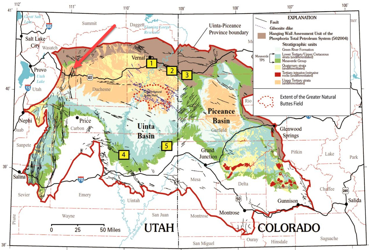
I’m seeing this as a test to the boundary of the Uinta Basin. The basin has had good luck lately using modern completion technology to produce the shale oil in Duchesne County. This well is very far from existing production (\>10 miles from the nearest real production). Also considering this is the only well marked with Green River Operating LLC in the area as the operator, my interpretation would be this is a wildcat investor hoping to get lucky.
My sources show 12,000’ depth and a vertical well, spud 11/14/2020 (current status is still “drilling”), which can be confirmed with satellite image. Likely the target is shallower Wasatch formation but they wanted plenty of room to explore. It’s probably no coincidence there’s a mapped set of faults right where they’re targeting, as that can sometimes work in your favor (but can be a pain to drill).
[https://sp.lyellcollection.org/content/374/1/23](https://sp.lyellcollection.org/content/374/1/23) 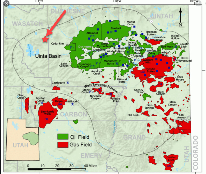
---
### Author:  [@M\_Barnes](https://www.mineralrightsforum.com/u/M_Barnes)
#### Post date: [January 4, 2021, 10:33pm UTC](https://www.mineralrightsforum.com/t/wasatch-county-utah-well-any-information/60021/7 "2021-01-04T22:33:22Z")
Nice maps! The Utah oil and gas commission will have a document that somewhere in it will state how long wells can be held on the confidential list. Various states have different time frames.
---
### Author:  [@system](https://www.mineralrightsforum.com/u/system)
#### Post date: [April 1, 2021, 6:41pm UTC](https://www.mineralrightsforum.com/t/wasatch-county-utah-well-any-information/60021/8 "2021-04-01T18:41:31Z")
This topic was automatically closed after 90 days. New replies are no longer allowed.