# Valuation Loving County purchase offer
**URL:** https://www.mineralrightsforum.com/t/valuation-loving-county-purchase-offer/32920
**Category:** Loving County, TX
**Created:** [September 3, 2018, 5:45pm UTC](https://www.mineralrightsforum.com/t/valuation-loving-county-purchase-offer/32920 "2018-09-03T17:45:26Z")
**Posts on this page:** 12
**Page:** 1
### Author:  [@Sallison](https://www.mineralrightsforum.com/u/Sallison)
#### Post date: [September 3, 2018, 5:45pm UTC](https://www.mineralrightsforum.com/t/valuation-loving-county-purchase-offer/32920/1 "2018-09-03T17:45:26Z")
We’re new to the forum and looking for guidance on getting independent valuation of mineral interests in Loving County. We have recent purchase offers and are seeking independent info on activity in the area. Found the Texas Railroad Commission site but not having much luck getting info on our parcel. Appreciate any assistance - thanks.
---
### Author:  [@bhiggins](https://www.mineralrightsforum.com/u/bhiggins)
#### Post date: [September 3, 2018, 6:07pm UTC](https://www.mineralrightsforum.com/t/valuation-loving-county-purchase-offer/32920/2 "2018-09-03T18:07:56Z")
What kind of information are you looking for on your parcel?
---
### Author:  [@Sallison](https://www.mineralrightsforum.com/u/Sallison)
#### Post date: [September 3, 2018, 6:47pm UTC](https://www.mineralrightsforum.com/t/valuation-loving-county-purchase-offer/32920/3 "2018-09-03T18:47:18Z")
Drilling, permitting, production would be helpful. We know about the latest overall trends in Loving County, but don’t know how to factor that into value.
---
### Author:  [@bhiggins](https://www.mineralrightsforum.com/u/bhiggins)
#### Post date: [September 3, 2018, 7:02pm UTC](https://www.mineralrightsforum.com/t/valuation-loving-county-purchase-offer/32920/4 "2018-09-03T19:02:45Z")
You didn’t have any luck on [http://wwwgisp.rrc.texas.gov/GISViewer2/](http://wwwgisp.rrc.texas.gov/GISViewer2/)?
What’s your property legal description? I’ll see if I can locate it.
---
### Author:  [@Sallison](https://www.mineralrightsforum.com/u/Sallison)
#### Post date: [September 3, 2018, 7:21pm UTC](https://www.mineralrightsforum.com/t/valuation-loving-county-purchase-offer/32920/5 "2018-09-03T19:21:26Z")
The legal description is SE/4 of Section 12, Block 55, Township 2, Loving County. Thanks for your help!
---
### Author:  [@bhiggins](https://www.mineralrightsforum.com/u/bhiggins)
#### Post date: [September 3, 2018, 7:40pm UTC](https://www.mineralrightsforum.com/t/valuation-loving-county-purchase-offer/32920/6 "2018-09-03T19:40:12Z")
I’m having problems with the RRC today too. However, I was able to get some images to show you where the property is.
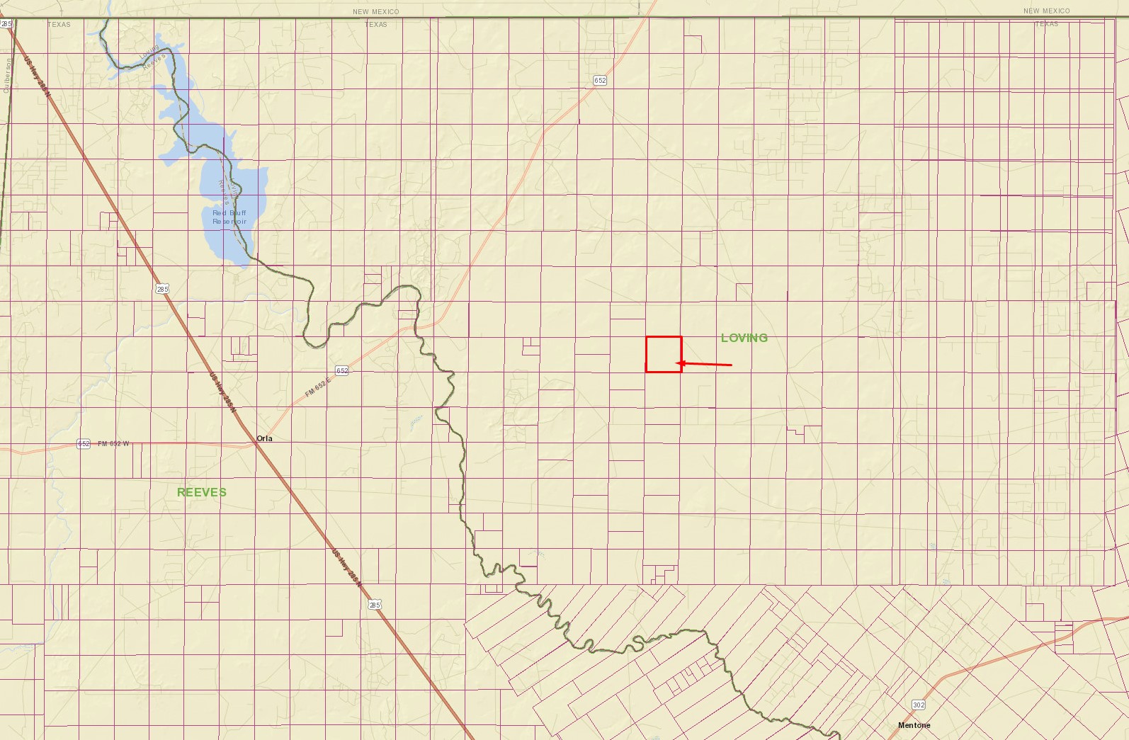
In relation to the county:
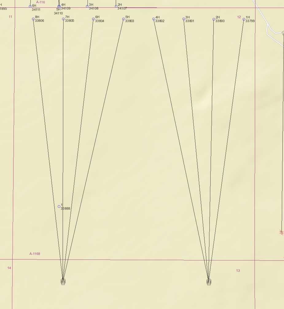
Permits on the section:
Bonus! Looks like there is drilling in progress (1H) and 3 drilled uncompleted wells (2H-4H):
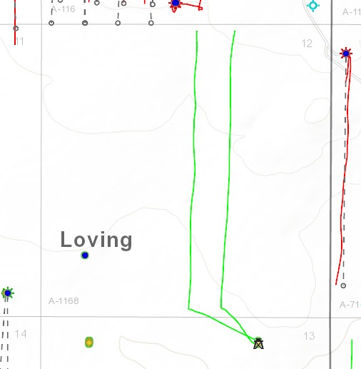
[https://info.drillinginfo.com/](https://info.drillinginfo.com/)
---
### Author:  [@Sallison](https://www.mineralrightsforum.com/u/Sallison)
#### Post date: [September 3, 2018, 7:52pm UTC](https://www.mineralrightsforum.com/t/valuation-loving-county-purchase-offer/32920/7 "2018-09-03T19:52:06Z")
This is very helpful! With regard to the drilling, is it on our parcel or just in that section?
---
### Author:  [@bhiggins](https://www.mineralrightsforum.com/u/bhiggins)
#### Post date: [September 3, 2018, 8:04pm UTC](https://www.mineralrightsforum.com/t/valuation-loving-county-purchase-offer/32920/8 "2018-09-03T20:04:14Z")
The SE/4 would look something like this:
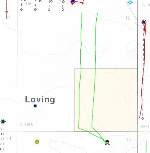
So yes, it would appear the wells traverse your parcel. The fact that DI is missing the permits and is only showing 2 of the DUCs, I would be a little hesitant until you can verify with the RRC. Either way it’s looking promising!
---
### Author:  [@Sallison](https://www.mineralrightsforum.com/u/Sallison)
#### Post date: [September 5, 2018, 8:22am UTC](https://www.mineralrightsforum.com/t/valuation-loving-county-purchase-offer/32920/9 "2018-09-05T08:22:01Z")
Really appreciate your help - which application would you search on the RR Commission site to get info on what’s happening now? Thanks again!
---
### Author:  [@bhiggins](https://www.mineralrightsforum.com/u/bhiggins)
#### Post date: [September 5, 2018, 1:28pm UTC](https://www.mineralrightsforum.com/t/valuation-loving-county-purchase-offer/32920/10 "2018-09-05T13:28:01Z")
Sadly the RRC doesn’t track events between permitting and completion. You would need to subscribe to a 3rd party service. However, after completion, you can use the RRC GIS viewer and RRC Completion query to follow what’s happening from then on.
---
### Author:  [@Matt\_Sands](https://www.mineralrightsforum.com/u/Matt_Sands)
#### Post date: [September 5, 2018, 2:37pm UTC](https://www.mineralrightsforum.com/t/valuation-loving-county-purchase-offer/32920/11 "2018-09-05T14:37:31Z")
In addition to the info that Bill has already provided, in reviewing the well permits, it appears that your acreage is part of a 649 acre pooled unit containing all of Section 12. Assuming your lease provisions allow (which based on the fact that they have created a pooled unit I assume it would), your acreage would participate in the production from these 8 wells proportionate to your acreage. (e.g. if you own 100% of minerals under the SE/4 you would have 152.3/649’ths of the production multiplied by your royalty rate - this is also called the Net Revenue Interest).
Please let me know if you need anything else! Thanks, Matt Sands
---
### Author:  [@MRFAdmin\_SV](https://www.mineralrightsforum.com/u/MRFAdmin_SV)
#### Post date: [January 11, 2025, 5:24pm UTC](https://www.mineralrightsforum.com/t/valuation-loving-county-purchase-offer/32920/12 "2025-01-11T17:24:15Z")