# Upcoming drilling activity
**URL:** https://www.mineralrightsforum.com/t/upcoming-drilling-activity/85493
**Category:** Eddy County, NM
**Created:** [January 15, 2026, 9:49pm UTC](https://www.mineralrightsforum.com/t/upcoming-drilling-activity/85493 "2026-01-15T21:49:04Z")
**Posts on this page:** 17
**Page:** 1
### Author:  [@HGW](https://www.mineralrightsforum.com/u/HGW)
#### Post date: [January 15, 2026, 9:49pm UTC](https://www.mineralrightsforum.com/t/upcoming-drilling-activity/85493/1 "2026-01-15T21:49:04Z")
My brother was told that there are 5 new permits issued on our rights. That’s all he knows and can’t give me more info. We have also received a few offers, suggesting new upcoming activity.
Does anybody know if new upcoming wells or activity is to be expected in Eddy County, in:
**Township 25 South, Range 28 East,**
**Section 11: SENE,**
**Section 12: SWNW + NWSW**
Thank you in advance!
---
### Author:  [@M\_Barnes](https://www.mineralrightsforum.com/u/M_Barnes)
#### Post date: [January 15, 2026, 11:16pm UTC](https://www.mineralrightsforum.com/t/upcoming-drilling-activity/85493/2 "2026-01-15T23:16:43Z")
You can use the NM GIS map to zoom into the area and the look up the surface locations of the wells. [ArcGIS Web Application](https://nm-emnrd.maps.arcgis.com/apps/webappviewer/index.html?id=4d017f2306164de29fd2fb9f8f35ca75)
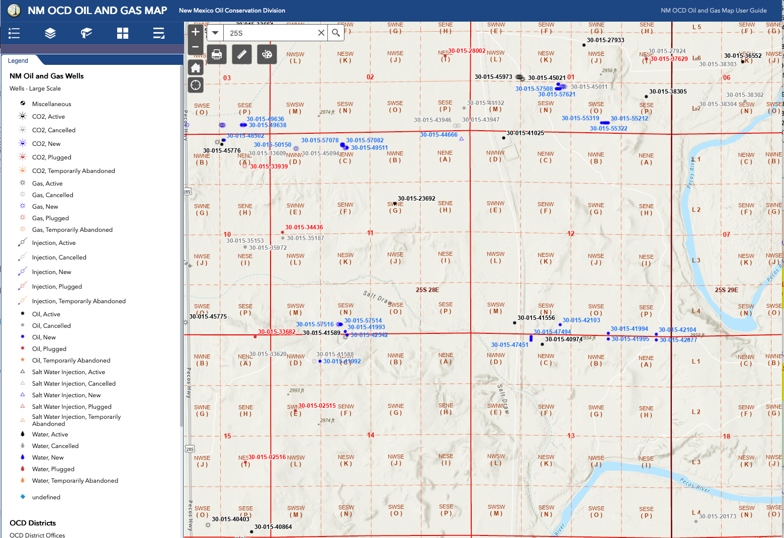
The west side of 11 has a rig onsite now drilling to the south into 14. (Coterra) The east side of 11 has surface locations in the northern part of 2 (Mewbourne). 12 has surface location in section 1 drilling through 12 into 13. (Coterra)
---
### Author:  [@HGW](https://www.mineralrightsforum.com/u/HGW)
#### Post date: [January 16, 2026, 1:52am UTC](https://www.mineralrightsforum.com/t/upcoming-drilling-activity/85493/3 "2026-01-16T01:52:47Z")
Thank you for providing that! Are these new wells? I should have said that we are receiving royalties from Mewbourne and Coterra already. I was wondering if there were any new upcoming wells to look out for. Thanks again.
---
### Author:  [@HGW](https://www.mineralrightsforum.com/u/HGW)
#### Post date: [January 16, 2026, 2:03am UTC](https://www.mineralrightsforum.com/t/upcoming-drilling-activity/85493/4 "2026-01-16T02:03:36Z")
Sorry to ask another question, but are the wells you are referring to all blue? I guess that means that they are new?
---
### Author:  [@NMoilboy](https://www.mineralrightsforum.com/u/NMoilboy)
#### Post date: [January 16, 2026, 5:37pm UTC](https://www.mineralrightsforum.com/t/upcoming-drilling-activity/85493/5 "2026-01-16T17:37:46Z")
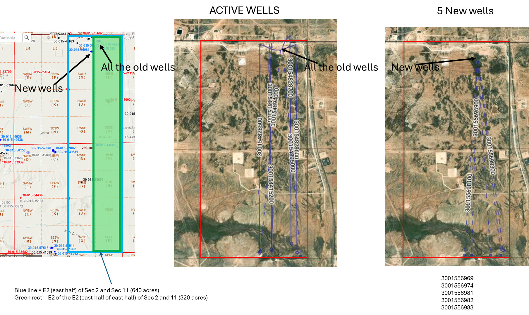
There are 5 more Hoss permits approved in July 2025. I didn’t check zones on them, but 3 of the 5 were in the E2 of the E2 of Section 2/Township 11 so those at a minimum should be in your acreage.
---
### Author:  [@NMoilboy](https://www.mineralrightsforum.com/u/NMoilboy)
#### Post date: [January 16, 2026, 5:53pm UTC](https://www.mineralrightsforum.com/t/upcoming-drilling-activity/85493/6 "2026-01-16T17:53:57Z")
Laugh. Well this is the kind of attention to detail one might apply if one’s well decimal started with 5 zeroes. All of those wells have spud. They are all BoneSpring wells.
---
### Author:  [@HGW](https://www.mineralrightsforum.com/u/HGW)
#### Post date: [January 19, 2026, 12:00am UTC](https://www.mineralrightsforum.com/t/upcoming-drilling-activity/85493/7 "2026-01-19T00:00:06Z")
I don’t think I know enough to understand what you mean.
---
### Author:  [@HGW](https://www.mineralrightsforum.com/u/HGW)
#### Post date: [January 19, 2026, 12:00am UTC](https://www.mineralrightsforum.com/t/upcoming-drilling-activity/85493/8 "2026-01-19T00:00:44Z")
Thank you for answering!
---
### Author:  [@M\_Barnes](https://www.mineralrightsforum.com/u/M_Barnes)
#### Post date: [January 19, 2026, 2:22pm UTC](https://www.mineralrightsforum.com/t/upcoming-drilling-activity/85493/9 "2026-01-19T14:22:53Z")
You already have a few horizontal wells in those sections. These are new permits within the last 24 months.
---
### Author:  [@NMoilboy](https://www.mineralrightsforum.com/u/NMoilboy)
#### Post date: [January 19, 2026, 2:55pm UTC](https://www.mineralrightsforum.com/t/upcoming-drilling-activity/85493/10 "2026-01-19T14:55:21Z")
And the new permits have all been drilled.
---
### Author:  [@M\_Barnes](https://www.mineralrightsforum.com/u/M_Barnes)
#### Post date: [January 19, 2026, 3:08pm UTC](https://www.mineralrightsforum.com/t/upcoming-drilling-activity/85493/11 "2026-01-19T15:08:44Z")
The last five HOSS wells are still listed as DUCs on Enverus. They spud in Sept 2025.
---
### Author:  [@HGW](https://www.mineralrightsforum.com/u/HGW)
#### Post date: [January 19, 2026, 10:34pm UTC](https://www.mineralrightsforum.com/t/upcoming-drilling-activity/85493/12 "2026-01-19T22:34:11Z")
Thank you for answering, I appreciate it!
---
### Author:  [@HGW](https://www.mineralrightsforum.com/u/HGW)
#### Post date: [January 19, 2026, 11:23pm UTC](https://www.mineralrightsforum.com/t/upcoming-drilling-activity/85493/13 "2026-01-19T23:23:19Z")
@M_Barnes & @NMoilboy - Ok, I must be missing something. Because our sections are
**Section 11: SENE (“H” on the map)**
**Section 12: SWNW + NWSW (“E” and “L” on the map)**
When I look at those sections on the NM GIS map, I don’t see any wells IN those sections. Would either of you help me understand what I’m missing here? I’m truly lost.
Thank you so much again!
---
### Author:  [@HGW](https://www.mineralrightsforum.com/u/HGW)
#### Post date: [January 19, 2026, 11:25pm UTC](https://www.mineralrightsforum.com/t/upcoming-drilling-activity/85493/14 "2026-01-19T23:25:44Z")
> E2 of the E2 of Sec2/11
Would that be the section called “H” on the map? If not, would you tell me which letter it is on the map?
---
### Author:  [@NMoilboy](https://www.mineralrightsforum.com/u/NMoilboy)
#### Post date: [January 20, 2026, 3:10pm UTC](https://www.mineralrightsforum.com/t/upcoming-drilling-activity/85493/15 "2026-01-20T15:10:27Z")
The GIS map does not show the laterals (the horizontal part of a well), just the surface location as a dot. So it, sadly, is a **really bad way to look at horizontal wells**. You’d need to find the well API dot and then scroll down to hit “well details” to go to the NMOCD page that has more info.
I will confess that I pretty much never use GIS map unless I am looking up a lease outline, but I have access to better subscription services. So I don’t necessarily have a better suggestion for you.
Here are some maps. Maybe helps, maybe doesn’t. GIS Map and then a map from subscription service showing horizontal laterals. The E2 of the E2 of Sec 2 and 11 would include LOT H (SE of NE).
---
### Author:  [@HGW](https://www.mineralrightsforum.com/u/HGW)
#### Post date: [January 20, 2026, 8:09pm UTC](https://www.mineralrightsforum.com/t/upcoming-drilling-activity/85493/16 "2026-01-20T20:09:19Z")
Thank you so much NM oilboy, that was so helpful!
---
### Author:  [@system](https://www.mineralrightsforum.com/u/system)
#### Post date: [April 15, 2026, 9:49pm UTC](https://www.mineralrightsforum.com/t/upcoming-drilling-activity/85493/17 "2026-04-15T21:49:50Z")
This topic was automatically closed after 90 days. New replies are no longer allowed.