# Sw/4 Section 10 Block 25
**URL:** https://www.mineralrightsforum.com/t/sw-4-section-10-block-25/68170
**Category:** Howard County, TX
**Created:** [October 2, 2022, 7:21pm UTC](https://www.mineralrightsforum.com/t/sw-4-section-10-block-25/68170 "2022-10-02T19:21:52Z")
**Posts on this page:** 5
**Page:** 1
### Author:  [@PurpleMoon](https://www.mineralrightsforum.com/u/PurpleMoon)
#### Post date: [October 2, 2022, 7:21pm UTC](https://www.mineralrightsforum.com/t/sw-4-section-10-block-25/68170/1 "2022-10-02T19:21:52Z")
First I want to Thank you for any and all help!! I am very new to the Mineral Rights/Deed world as our family just found out about our inheritance. And in my quest for research I found this forum. Though the information I have is minimum I’m trying to find our well/lease name, API # & Lease #.. The only information we were given was Southwest Quarter (SW/4) Section 10 Block 25. Via H&TC RR Co Survey and HighPeak. Out of Howard County and we have 160 acres.. We were told the lease request was done and drilling was to start mid Aug.. So if anyone could please dumb this down for me to get a better understanding of how this all works and how to locate the right resources would be Greatly Appreciated!! Thank you for your time and help!!
---
### Author:  [@Mikro1TX](https://www.mineralrightsforum.com/u/Mikro1TX)
#### Post date: [October 2, 2022, 9:07pm UTC](https://www.mineralrightsforum.com/t/sw-4-section-10-block-25/68170/2 "2022-10-02T21:07:55Z")
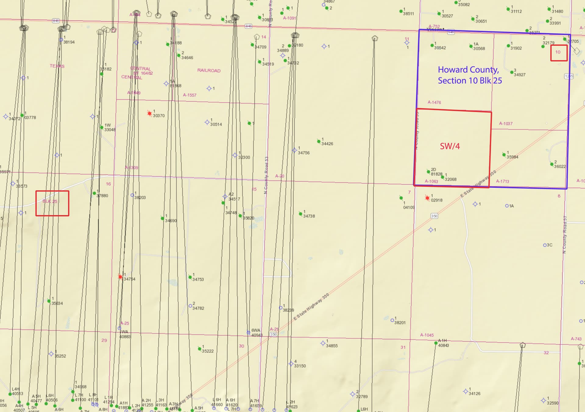
Looks like nothing happening in that part of the section. Just some shut-in wells. I hope this helps? BTW API numbers in Howard County start with 227 best I can tell. MK
---
### Author:  [@Clint\_Liles](https://www.mineralrightsforum.com/u/Clint_Liles)
#### Post date: [October 2, 2022, 11:24pm UTC](https://www.mineralrightsforum.com/t/sw-4-section-10-block-25/68170/3 "2022-10-02T23:24:40Z")
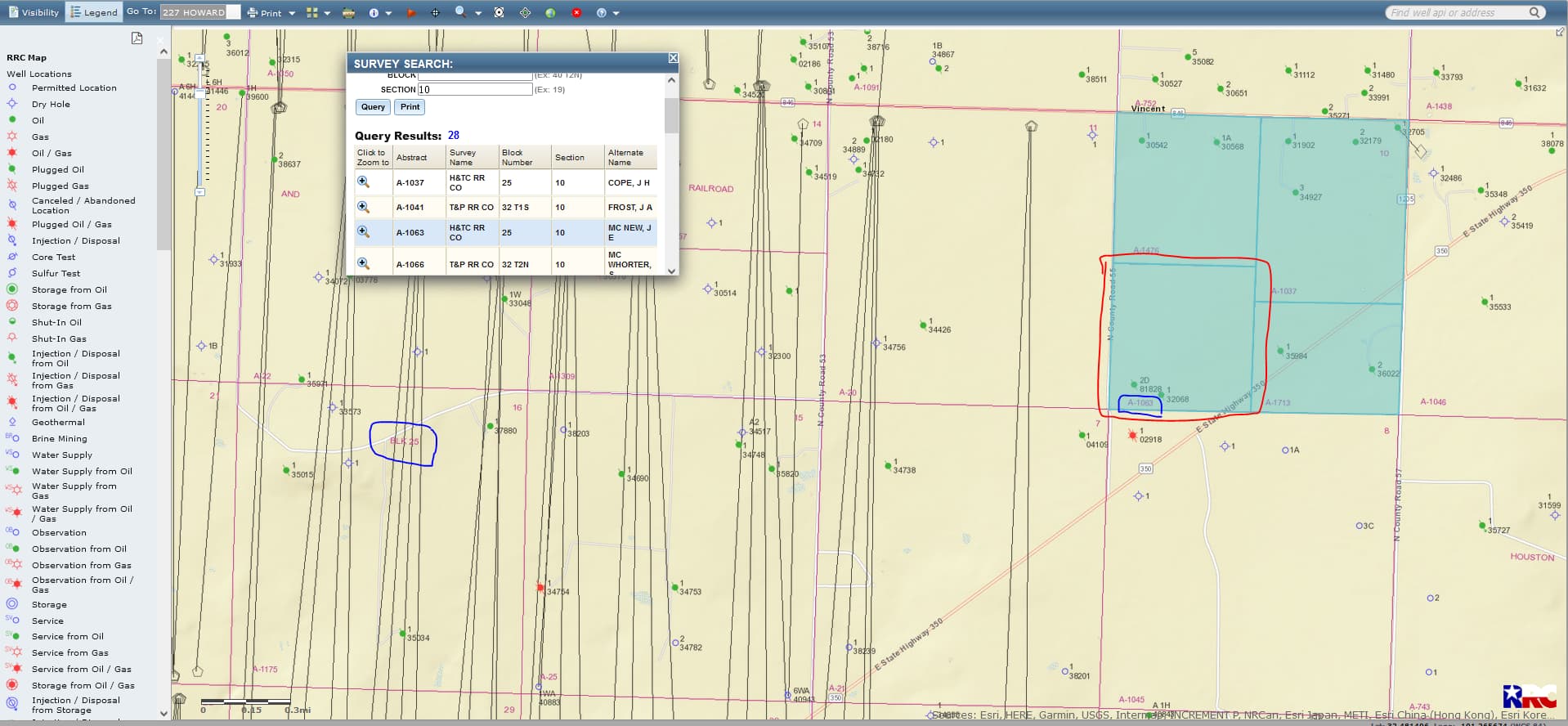
Purple Moon welcome to the Forum…use this link in finding your SW/4 of Section 10/Block 25/Abstract 1063 of Howard County… [https://gis.rrc.texas.gov/gisviewer/](https://gis.rrc.texas.gov/gisviewer/) From the production data I have viewed the oil/gas wells are not too good in this area of the County
CLICK ON MAP TO ENLARGE
---
### Author:  [@PurpleMoon](https://www.mineralrightsforum.com/u/PurpleMoon)
#### Post date: [October 2, 2022, 11:46pm UTC](https://www.mineralrightsforum.com/t/sw-4-section-10-block-25/68170/4 "2022-10-02T23:46:41Z")
Thank you both so much for your replies and info you shared! You have no idea how much I appreciate it! I have been trying to find any and everything I could read and either the sites are bad or are not up to date. Thank you for sharing and have a blessed night!
---
### Author:  [@system](https://www.mineralrightsforum.com/u/system)
#### Post date: [December 31, 2022, 7:22pm UTC](https://www.mineralrightsforum.com/t/sw-4-section-10-block-25/68170/5 "2022-12-31T19:22:45Z")
This topic was automatically closed after 90 days. New replies are no longer allowed.