# Send your block/section/survey name and i'll send you a picture of where your property is
**URL:** https://www.mineralrightsforum.com/t/send-your-block-section-survey-name-and-ill-send-you-a-picture-of-where-your-property-is/11417
**Category:** Ward County, TX
**Created:** [February 28, 2014, 1:40am UTC](https://www.mineralrightsforum.com/t/send-your-block-section-survey-name-and-ill-send-you-a-picture-of-where-your-property-is/11417 "2014-02-28T01:40:40Z")
**Posts on this page:** 20
**Page:** 6
### Author:  [@Richard\_Kyle\_Milner](https://www.mineralrightsforum.com/u/Richard_Kyle_Milner)
#### Post date: [August 30, 2017, 2:43pm UTC](https://www.mineralrightsforum.com/t/send-your-block-section-survey-name-and-ill-send-you-a-picture-of-where-your-property-is/11417/101 "2017-08-30T14:43:50Z")
I have three sites.
Sec 46, Blk. 33
Sec 184, Blk 34
Sec 135 Blk 42
Thanks
---
### Author:  [@Clint\_Liles](https://www.mineralrightsforum.com/u/Clint_Liles)
#### Post date: [August 30, 2017, 3:35pm UTC](https://www.mineralrightsforum.com/t/send-your-block-section-survey-name-and-ill-send-you-a-picture-of-where-your-property-is/11417/102 "2017-08-30T15:35:58Z")
Richard Milner: Ward County Section 46/Block 33
Richard at this time I see no new activity close by Section 46. I am posting production data on well 475-36952/Lease #46661 located in Section 25 next door. Good horizontal oil and gas well drilled by Oxy in 2014:
[http://webapps2.rrc.state.tx.us/EWA/specificLeaseQueryAction.do?tab=init&viewType=prodAndTotalDisp&methodToCall=fromGisViewer&pdqSearchArgs.paramValue=](http://webapps2.rrc.state.tx.us/EWA/specificLeaseQueryAction.do?tab=init&viewType=prodAndTotalDisp&methodToCall=fromGisViewer&pdqSearchArgs.paramValue=%7C2=07%7C3=2016%7C4=06%7C5=2017%7C103=46661%7C6=O%7C102=08%7C8=specificlease%7C204=district%7C9=dispdetails%7C10=0)
Link to completion report on well 575-36952: (948 barrel oil per day/5,213,000 cubic feet gas per day):
[http://webapps.rrc.texas.gov/CMPL/viewPdfReportFormAction.do?method=cmplW2FormPdf&packetSummaryId=137161](http://webapps.rrc.texas.gov/CMPL/viewPdfReportFormAction.do?method=cmplW2FormPdf&packetSummaryId=137161)
GIS map of Ward County Section 46/Block 33:
![Map]()
CLICK ON MAP TO ENLARGE
Richard, I have some business to take care of in Tyler. Later I will look at the other 2 locations you have listed.
---
### Author:  [@Linton\_Tomlin](https://www.mineralrightsforum.com/u/Linton_Tomlin)
#### Post date: [August 30, 2017, 4:30pm UTC](https://www.mineralrightsforum.com/t/send-your-block-section-survey-name-and-ill-send-you-a-picture-of-where-your-property-is/11417/103 "2017-08-30T16:30:23Z")
Hi, Richard. The attached images are for Block 33/Section 46 and Block 34/Section 184, denoted by the hot pink markers on the map. I could not find a Block 42. Clint will probably help me find it when he gets back! Linton Tomlin
1951-IMG\_20170830\_112254.jpg (547 KB)
1952-IMG\_20170830\_112232.jpg (576 KB)
---
### Author:  [@Clint\_Liles](https://www.mineralrightsforum.com/u/Clint_Liles)
#### Post date: [August 30, 2017, 9:58pm UTC](https://www.mineralrightsforum.com/t/send-your-block-section-survey-name-and-ill-send-you-a-picture-of-where-your-property-is/11417/104 "2017-08-30T21:58:43Z")
Richard Milner: Ward County Section 184/Block 34/A-351
2 dry holes (32276 & 32477) drilled in Section 184 in 1981. Wildcat wells drilled to only 6700’… should have gone deeper.
Production data link to 2 horizontal wells (36925 & 37090) (Lease #46820) next door to the East of Section 184 operated by COG (Concho Oil and Gas). The production of these 2 wells is commingled into one lease:
[http://webapps2.rrc.state.tx.us/EWA/specificLeaseQueryAction.do?tab=init&viewType=prodAndTotalDisp&methodToCall=fromGisViewer&pdqSearchArgs.paramValue=](http://webapps2.rrc.state.tx.us/EWA/specificLeaseQueryAction.do?tab=init&viewType=prodAndTotalDisp&methodToCall=fromGisViewer&pdqSearchArgs.paramValue=%7C2=07%7C3=2016%7C4=06%7C5=2017%7C103=46820%7C6=O%7C102=08%7C8=specificlease%7C204=district%7C9=dispdetails%7C10=0)
GIS (Geographic Information System) map of Ward County Section 184/Block 34/A-351 and surrounding area:
CLICK ON MAP TO ENLARGE
---
### Author:  [@Clint\_Liles](https://www.mineralrightsforum.com/u/Clint_Liles)
#### Post date: [August 30, 2017, 10:24pm UTC](https://www.mineralrightsforum.com/t/send-your-block-section-survey-name-and-ill-send-you-a-picture-of-where-your-property-is/11417/105 "2017-08-30T22:24:13Z")
Richard Milner:Ward County Section 135/Block 34/A-245
GIS Mapping system could not locate a Block 42 in Ward County. The only Section 135 is in Block 34....so here we are.
I find 6 plugged oil wells in Section 135/1 dry hole=31741/Vertical well 31629 drilled in 1977/still producing/Production data link for well 31629:
[http://webapps2.rrc.state.tx.us/EWA/specificLeaseQueryAction.do?tab=init&viewType=prodAndTotalDisp&methodToCall=fromGisViewer&pdqSearchArgs.paramValue=|2=07|3=2016|4=06|5=2017|103=24880|6=O|102=08|8=specificlease|204=district|9=dispdetails|10=0](http://webapps2.rrc.state.tx.us/EWA/specificLeaseQueryAction.do?tab=init&viewType=prodAndTotalDisp&methodToCall=fromGisViewer&pdqSearchArgs.paramValue=|2=07|3=2016|4=06|5=2017|103=24880|6=O|102=08|8=specificlease|204=district|9=dispdetails|10=0)
Some good horizontal wells to the East, West, and South of Section 135.
GIS Map of Ward County Section 135/Block 34/A-245 and surrounding area:
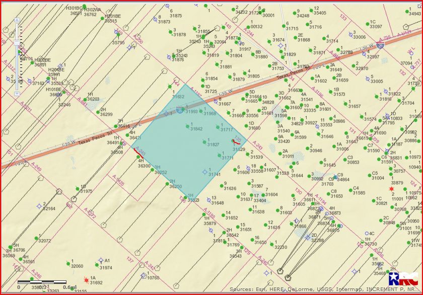
CLICK ON MAP TO ENLARGE
Clint Liles
---
### Author:  [@Linton\_Tomlin](https://www.mineralrightsforum.com/u/Linton_Tomlin)
#### Post date: [August 30, 2017, 11:37pm UTC](https://www.mineralrightsforum.com/t/send-your-block-section-survey-name-and-ill-send-you-a-picture-of-where-your-property-is/11417/106 "2017-08-30T23:37:51Z")
Glad you couldn’t find it either, thought maybe I was losing my touch! I’ll take a picture of this one for Richard, too.
---
### Author:  [@Linton\_Tomlin](https://www.mineralrightsforum.com/u/Linton_Tomlin)
#### Post date: [August 30, 2017, 11:46pm UTC](https://www.mineralrightsforum.com/t/send-your-block-section-survey-name-and-ill-send-you-a-picture-of-where-your-property-is/11417/107 "2017-08-30T23:46:40Z")
Okay, Richard, here’s your Blk 34//Sec 135… Linton
---
### Author:  [@Linda\_Silvertooth](https://www.mineralrightsforum.com/u/Linda_Silvertooth)
#### Post date: [November 11, 2017, 11:47pm UTC](https://www.mineralrightsforum.com/t/send-your-block-section-survey-name-and-ill-send-you-a-picture-of-where-your-property-is/11417/108 "2017-11-11T23:47:41Z")
Hello, I have 4.24 acres in Block 34, Section 59. Thank you so much if you could post a picture of it and send it to my email at [lindasilvertooth@gmail.com](mailto:lindasilvertooth@gmail.com). Thank you! Linda
---
### Author:  [@Linton\_Tomlin](https://www.mineralrightsforum.com/u/Linton_Tomlin)
#### Post date: [November 12, 2017, 12:32am UTC](https://www.mineralrightsforum.com/t/send-your-block-section-survey-name-and-ill-send-you-a-picture-of-where-your-property-is/11417/109 "2017-11-12T00:32:56Z")
Hi, Linda! I’m having camera issues, but I hope these help you out. Your Section 59 is the hot pink on the farthest right. Good luck! Linton
---
### Author:  [@mineral\_rights\_holder](https://www.mineralrightsforum.com/u/mineral_rights_holder)
#### Post date: [November 13, 2017, 3:08pm UTC](https://www.mineralrightsforum.com/t/send-your-block-section-survey-name-and-ill-send-you-a-picture-of-where-your-property-is/11417/110 "2017-11-13T15:08:56Z")
Thanks for this - I have rights to Section 174, Block 34, H&TC RR survey and would appreciate knowing.
Am also wondering about current fair signing bonus rates in this area.
---
### Author:  [@Linton\_Tomlin](https://www.mineralrightsforum.com/u/Linton_Tomlin)
#### Post date: [November 14, 2017, 6:32pm UTC](https://www.mineralrightsforum.com/t/send-your-block-section-survey-name-and-ill-send-you-a-picture-of-where-your-property-is/11417/111 "2017-11-14T18:32:40Z")
Here you go, Shaw. Your Section is marked with the hot pink marker. I’m certainly no expert on bonuses in that area, or even familiar with bonus amounts in that area, but I would guess at least $2,250-$3,500. Maybe someone with more knowledge than I will respond. Linton
 (534 KB)
 (639 KB)
---
### Author:  [@mineral\_rights\_holder](https://www.mineralrightsforum.com/u/mineral_rights_holder)
#### Post date: [November 14, 2017, 6:36pm UTC](https://www.mineralrightsforum.com/t/send-your-block-section-survey-name-and-ill-send-you-a-picture-of-where-your-property-is/11417/112 "2017-11-14T18:36:03Z")
Thanks!
---
### Author:  [@Paul\_W](https://www.mineralrightsforum.com/u/Paul_W)
#### Post date: [November 16, 2017, 8:12pm UTC](https://www.mineralrightsforum.com/t/send-your-block-section-survey-name-and-ill-send-you-a-picture-of-where-your-property-is/11417/113 "2017-11-16T20:12:46Z")
Section 228, Block 34 H&TC RR CO. Survey
Thank you!
---
### Author:  [@Robert\_Coovert](https://www.mineralrightsforum.com/u/Robert_Coovert)
#### Post date: [January 17, 2018, 3:41pm UTC](https://www.mineralrightsforum.com/t/send-your-block-section-survey-name-and-ill-send-you-a-picture-of-where-your-property-is/11417/114 "2018-01-17T15:41:15Z")
Block 34 Section 172 H&TC RR survey. Thank you sir, I certainly appreciate it.
---
### Author:  [@Linton\_Tomlin](https://www.mineralrightsforum.com/u/Linton_Tomlin)
#### Post date: [January 17, 2018, 5:49pm UTC](https://www.mineralrightsforum.com/t/send-your-block-section-survey-name-and-ill-send-you-a-picture-of-where-your-property-is/11417/115 "2018-01-17T17:49:50Z")
You’re welcome Robert. Let me know if you have any problems or need something closer. Linton
---
### Author:  [@Linton\_Tomlin](https://www.mineralrightsforum.com/u/Linton_Tomlin)
#### Post date: [January 17, 2018, 5:51pm UTC](https://www.mineralrightsforum.com/t/send-your-block-section-survey-name-and-ill-send-you-a-picture-of-where-your-property-is/11417/116 "2018-01-17T17:51:50Z")
Forgot to tell you, Section 172 is where hot pink marker is. Linton
---
### Author:  [@Robert\_Coovert](https://www.mineralrightsforum.com/u/Robert_Coovert)
#### Post date: [January 17, 2018, 6:44pm UTC](https://www.mineralrightsforum.com/t/send-your-block-section-survey-name-and-ill-send-you-a-picture-of-where-your-property-is/11417/117 "2018-01-17T18:44:26Z")
Thanks Linton, I’m new to this, how do I see attachments?
---
### Author:  [@Elizabeth\_Christy\_Barton](https://www.mineralrightsforum.com/u/Elizabeth_Christy_Barton)
#### Post date: [January 18, 2018, 2:20pm UTC](https://www.mineralrightsforum.com/t/send-your-block-section-survey-name-and-ill-send-you-a-picture-of-where-your-property-is/11417/118 "2018-01-18T14:20:38Z")
Section 63, Block 34 H&TC RR CO. Survey. Thank you so much! Elizabeth
---
### Author:  [@Linton\_Tomlin](https://www.mineralrightsforum.com/u/Linton_Tomlin)
#### Post date: [January 18, 2018, 4:14pm UTC](https://www.mineralrightsforum.com/t/send-your-block-section-survey-name-and-ill-send-you-a-picture-of-where-your-property-is/11417/119 "2018-01-18T16:14:49Z")
Robert, I don’t see where your pictures posted. Weird. I’ll try again. I already erased your pictures, though, so I’ll go take more!! Sorry.
---
### Author:  [@Linton\_Tomlin](https://www.mineralrightsforum.com/u/Linton_Tomlin)
#### Post date: [January 18, 2018, 4:21pm UTC](https://www.mineralrightsforum.com/t/send-your-block-section-survey-name-and-ill-send-you-a-picture-of-where-your-property-is/11417/120 "2018-01-18T16:21:01Z")
Robert, until I can get to my map, here is an older photo I have on my phone. Block 34, Section 172 is on the far left. Hope this one posts. Linton
[2381-MVIMG\_20180113\_185301.jpg](https://www.mineralrightsforum.com/uploads/db5755/original/2X/c/c3c5518ede34c5f37b15323112157efd078621a6.jpg) (355 KB)
[Previous page](https://www.mineralrightsforum.com/t/send-your-block-section-survey-name-and-ill-send-you-a-picture-of-where-your-property-is/11417.md?page=5)
[Next page](https://www.mineralrightsforum.com/t/send-your-block-section-survey-name-and-ill-send-you-a-picture-of-where-your-property-is/11417.md?page=7)