# Seismic permit with lease option
**URL:** https://www.mineralrightsforum.com/t/seismic-permit-with-lease-option/9951
**Category:** Archer County, TX
**Created:** [July 7, 2014, 11:13pm UTC](https://www.mineralrightsforum.com/t/seismic-permit-with-lease-option/9951 "2014-07-07T23:13:42Z")
**Posts on this page:** 5
**Page:** 1
### Author:  [@Travis\_Seigal](https://www.mineralrightsforum.com/u/Travis_Seigal)
#### Post date: [July 7, 2014, 11:13pm UTC](https://www.mineralrightsforum.com/t/seismic-permit-with-lease-option/9951/1 "2014-07-07T23:13:42Z")
Hello everyone. My sister and I just found out we own mineral rights in Archer County, Texas. It was a shock and we are trying to get as much info as we can before we make a decision. We have been offered a seismic permit with option to lease. We would like to find out if the seismic permit with option to lease is normally signed together. Also, they are offering $15 per acre for 12 months for the seismic permit. Is that good? The option to lease is a three-year at $90 per net mineral acre and 1/6 royalty. There is no mention of a lease bonus. Any comments are appreciated, thanks.
---
### Author:  [@Clint\_Liles](https://www.mineralrightsforum.com/u/Clint_Liles)
#### Post date: [July 8, 2014, 1:01am UTC](https://www.mineralrightsforum.com/t/seismic-permit-with-lease-option/9951/2 "2014-07-08T01:01:47Z")
Travis,
Is there any production or any drilling activity around your minerals area? What is the Abstract, Block, and Section number of your minerals acreage? Let’s pull this up on the GIS map and see what’s in the area. 1/6 royalty and $90 is definitely too cheap nowadays for any lease. That’s an insult.
---
### Author:  [@Travis\_Seigal](https://www.mineralrightsforum.com/u/Travis_Seigal)
#### Post date: [July 8, 2014, 1:55am UTC](https://www.mineralrightsforum.com/t/seismic-permit-with-lease-option/9951/3 "2014-07-08T01:55:34Z")
All we have for location is Hooper & Wade survey section 6 abstract 1107. I appreciate any help we can get, thanks Clint.
---
### Author:  [@Clint\_Liles](https://www.mineralrightsforum.com/u/Clint_Liles)
#### Post date: [July 8, 2014, 2:36am UTC](https://www.mineralrightsforum.com/t/seismic-permit-with-lease-option/9951/4 "2014-07-08T02:36:43Z")
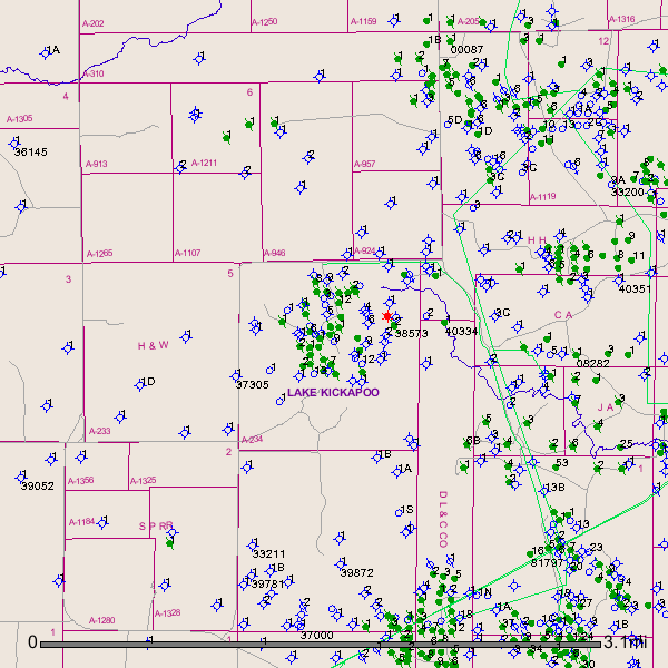
Travis, I see numerous dry holes have been drilled in the past in the surrounding area. Also to the northeast, east and southeast are numerous plugged oil wells and possibly a few producing oil wells. The blue circles with sticks through them are dry holes. The green circles with 2 sticks are plugged oil wells and the green circles are possibly producing oil wells. This is a link to a well in Abstract 234:
[http://webapps2.rrc.state.tx.us/EWA/drillingPermitDetailAction.do?methodToCall=searchByUniversalDocNo&universalDocNo=340464&rrcActionMan=H4sIAAAAAAAAAL1QwWrDMAz9mu5oZKctyUGHMLrz2pX1EHpwE5ManDjIDtvAHz8lY9ClO\_fkp6fnpyclCYAqSZAon4jqso7W94eamgrOOPMf5qKHISjBbRGijkbETzGGVVbmwAqFK\_WyO5UMswk2ZJ2zfftqqLMx7EdDXz-2ovEsWmNn4tU3R\_-snWNig2TiSP3RvxlN9ZWpHOEuTRXmbkltEIMm3b1rN5o5JGcAKLK8KKZV2PBiWtuHk42TGbv9qaVa1Lf6xVj5uCOE3-W3OOjW0M2S\_15EnqulbgqLMimUkDIGa4S04XfLxP3vh9zzG64NdylhAgAA](http://webapps2.rrc.state.tx.us/EWA/drillingPermitDetailAction.do?methodToCall=searchByUniversalDocNo&universalDocNo=340464&rrcActionMan=H4sIAAAAAAAAAL1QwWrDMAz9mu5oZKctyUGHMLrz2pX1EHpwE5ManDjIDtvAHz8lY9ClO_fkp6fnpyclCYAqSZAon4jqso7W94eamgrOOPMf5qKHISjBbRGijkbETzGGVVbmwAqFK_WyO5UMswk2ZJ2zfftqqLMx7EdDXz-2ovEsWmNn4tU3R_-snWNig2TiSP3RvxlN9ZWpHOEuTRXmbkltEIMm3b1rN5o5JGcAKLK8KKZV2PBiWtuHk42TGbv9qaVa1Lf6xVj5uCOE3-W3OOjW0M2S_15EnqulbgqLMimUkDIGa4S04XfLxP3vh9zzG64NdylhAgAA)
There is production in the area. Possibly someone else in the Archer County Group will chime in with some info on the bonus money per acre and the royalty percentage.
GIS Map of your Abstract # 1107 and surrounding area:
Clint Liles
---
### Author:  [@system](https://www.mineralrightsforum.com/u/system)
#### Post date: [August 15, 2018, 12:30am UTC](https://www.mineralrightsforum.com/t/seismic-permit-with-lease-option/9951/5 "2018-08-15T00:30:13Z")