# Section 19, block 7 H&G RR co. Survey, Reeves County A39
**URL:** https://www.mineralrightsforum.com/t/section-19-block-7-h-g-rr-co-survey-reeves-county-a39/54807
**Category:** Reeves County, TX
**Created:** [January 13, 2020, 2:49am UTC](https://www.mineralrightsforum.com/t/section-19-block-7-h-g-rr-co-survey-reeves-county-a39/54807 "2020-01-13T02:49:15Z")
**Posts on this page:** 10
**Page:** 1
### Author:  [@Susan\_Titus](https://www.mineralrightsforum.com/u/Susan_Titus)
#### Post date: [January 13, 2020, 2:49am UTC](https://www.mineralrightsforum.com/t/section-19-block-7-h-g-rr-co-survey-reeves-county-a39/54807/1 "2020-01-13T02:49:16Z")
Hello,
Can anyone provide a map of my section and the surrounding areas?
There are currently two horizontal wells that were drilled a couple of years ago that I get income from.
Parsley Energy drilled the wells and I’ve read they have recently acquired more acreage.
Thank you.
Susan Titus
---
### Author:  [@Dusty1](https://www.mineralrightsforum.com/u/Dusty1)
#### Post date: [January 13, 2020, 4:41am UTC](https://www.mineralrightsforum.com/t/section-19-block-7-h-g-rr-co-survey-reeves-county-a39/54807/2 "2020-01-13T04:41:00Z")
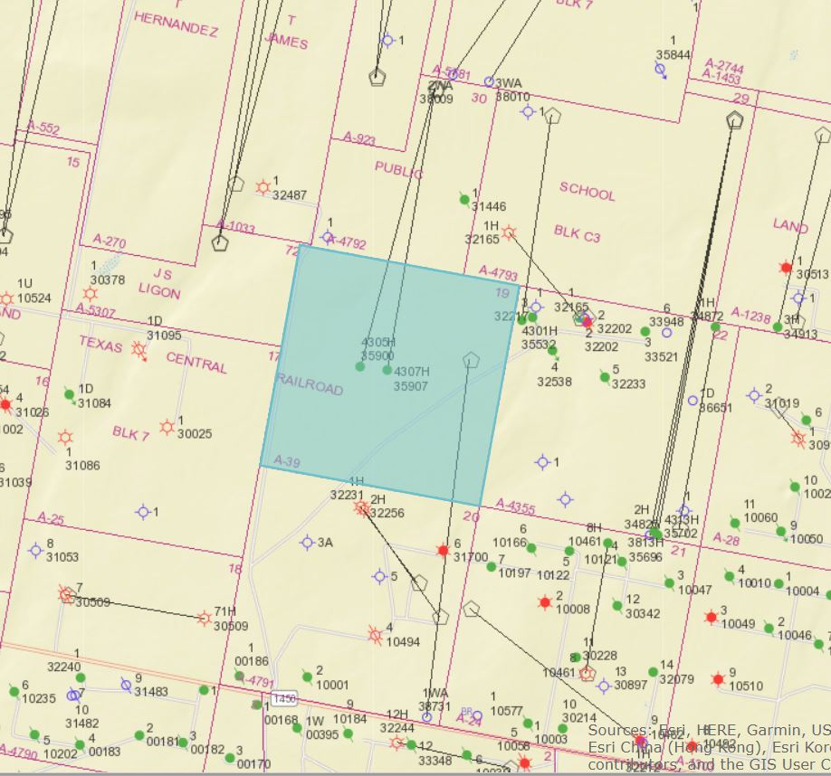
Attached below is the Railroad Commission’s map of your area, but you can pull it up yourself by using this link
[http://gis.rrc.texas.gov/GISViewer/](http://gis.rrc.texas.gov/GISViewer/)
In the pull-down menu at the upper left side of that page that says Select County, scroll down and select Reeves, then click it to pull up the map. Zoom in or out on the map by scrolling with your mouse and move to the part of the county you are interested in, or use another pull-down menu on the top line that looks like a magnifying glass, scroll down and select “Surveys”, enter 39 in the top blank marked Abstract A- then click and it will take you to that area of the map. Click on any of the well or permit symbols to see details on the operator, when drilled or production.
---
### Author:  [@Susan\_Titus](https://www.mineralrightsforum.com/u/Susan_Titus)
#### Post date: [January 14, 2020, 1:46am UTC](https://www.mineralrightsforum.com/t/section-19-block-7-h-g-rr-co-survey-reeves-county-a39/54807/3 "2020-01-14T01:46:09Z")
Hi Dusty,
Thanks so much for the map and instructions.
I fiddled around with this GIS viewer last night but I was entering the well name and couldn’t get anything to come up.
Susan Titus
---
### Author:  [@Susan\_Titus](https://www.mineralrightsforum.com/u/Susan_Titus)
#### Post date: [January 15, 2020, 8:15pm UTC](https://www.mineralrightsforum.com/t/section-19-block-7-h-g-rr-co-survey-reeves-county-a39/54807/4 "2020-01-15T20:15:48Z")
Can someone tell me what the hexagon-looking symbol means?
I see something in the block and section that the two wells are in but do not know if I’m a part of it.
It was not in the picture from a year ago.
Thank you.
---
### Author:  [@Clint\_Liles](https://www.mineralrightsforum.com/u/Clint_Liles)
#### Post date: [January 15, 2020, 10:03pm UTC](https://www.mineralrightsforum.com/t/section-19-block-7-h-g-rr-co-survey-reeves-county-a39/54807/5 "2020-01-15T22:03:58Z")
Hello Susan, That would be where the drilling pad is located—where the drilling rig set up and drilled the well(s). This link is to the “Legend” that tells you what all those thing-a-ma-jigs are.
[https://gis.rrc.texas.gov/GISViewer/GISViewer/docs/Public\_GIS\_Viewer\_Legend.pdf](https://gis.rrc.texas.gov/GISViewer/GISViewer/docs/Public_GIS_Viewer_Legend.pdf)
---
### Author:  [@Dusty1](https://www.mineralrightsforum.com/u/Dusty1)
#### Post date: [January 16, 2020, 3:14am UTC](https://www.mineralrightsforum.com/t/section-19-block-7-h-g-rr-co-survey-reeves-county-a39/54807/6 "2020-01-16T03:14:28Z")
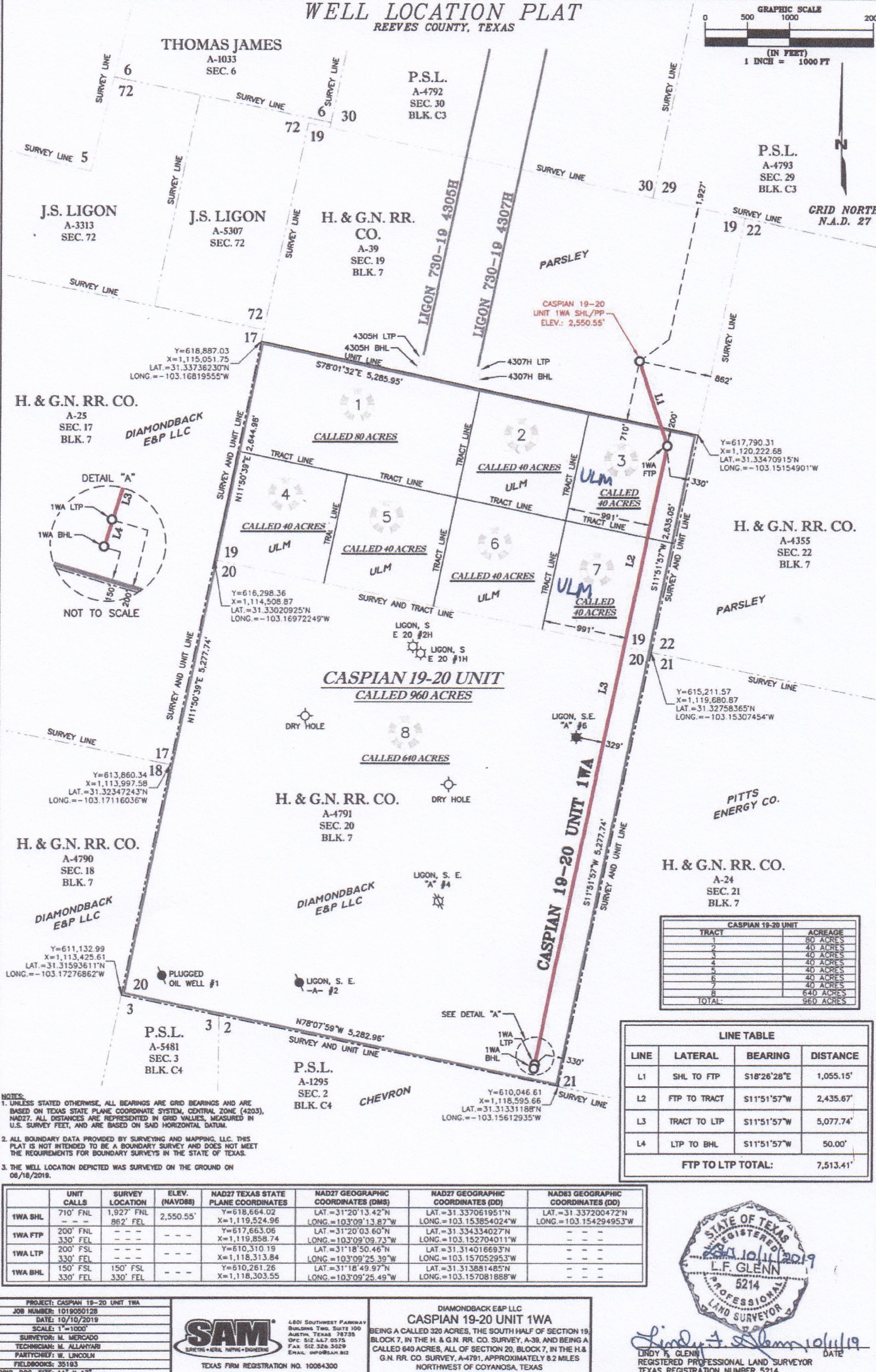
That drill pad Clint pointed out is for well Diamondback Energy permitted to drill in a separate unit from the unit from those two Parsley Ligon wells you said you have an interest in.
The plat for that Diamondback well, called the Caspian 19-20, is below. It shows the drill site is in the upper half of Section 19 but the first take point (FTP) is 1000 feet further south in the lower half of Section 19 so only acreage below that take point would share in that production.
It looks like that new well hasn’t been drilled yet because the drilling permit is still pending approval. When the permit application was filed in November, RRC questioned whether it would be an allocation well or part of a pooled unit and for some reason Diamondback never has responded to clear that up.
---
### Author:  [@Susan\_Titus](https://www.mineralrightsforum.com/u/Susan_Titus)
#### Post date: [January 17, 2020, 2:51pm UTC](https://www.mineralrightsforum.com/t/section-19-block-7-h-g-rr-co-survey-reeves-county-a39/54807/7 "2020-01-17T14:51:35Z")
Dusty and Clint,
Thanks for your responses to my post.
I’ve been receiving numerous phone calls and letters from companies asking if I want to sell my mineral rights. I thought something might be up in that area.
When I saw the updated map of the Section and Block where my two wells are I thought that was a well about to be drilled that I would be getting royalties from. Just wishful thinking.
Thanks again,
Susan Titus
---
### Author:  [@Dusty1](https://www.mineralrightsforum.com/u/Dusty1)
#### Post date: [January 18, 2020, 10:04pm UTC](https://www.mineralrightsforum.com/t/section-19-block-7-h-g-rr-co-survey-reeves-county-a39/54807/8 "2020-01-18T22:04:05Z")
Even if you are not directly involved, that new activity, or at least the drilling permit signaling that something may be coming in the lower half of your section, may have prompted the inquiries you are getting. It appears to be on hold right now, but if that adjacent well gets drilled and has strong results, it could encourage more drilling in your unit.
---
### Author:  [@Susan\_Titus](https://www.mineralrightsforum.com/u/Susan_Titus)
#### Post date: [January 19, 2020, 8:08pm UTC](https://www.mineralrightsforum.com/t/section-19-block-7-h-g-rr-co-survey-reeves-county-a39/54807/9 "2020-01-19T20:08:56Z")
Thanks, Dusty.
I had another company leave me a voice message yesterday.
I guess the entire Permian Basin is still a desired area even though oil prices dropped some.
---
### Author:  [@system](https://www.mineralrightsforum.com/u/system)
#### Post date: [April 12, 2020, 2:49am UTC](https://www.mineralrightsforum.com/t/section-19-block-7-h-g-rr-co-survey-reeves-county-a39/54807/10 "2020-04-12T02:49:19Z")
This topic was automatically closed after 90 days. New replies are no longer allowed.