# Section 12 Block 32 Township 1 North
**URL:** https://www.mineralrightsforum.com/t/section-12-block-32-township-1-north/54949
**Category:** Howard County, TX
**Created:** [January 16, 2020, 3:17pm UTC](https://www.mineralrightsforum.com/t/section-12-block-32-township-1-north/54949 "2020-01-16T15:17:15Z")
**Posts on this page:** 3
**Page:** 1
### Author:  [@jthorns](https://www.mineralrightsforum.com/u/jthorns)
#### Post date: [January 16, 2020, 3:17pm UTC](https://www.mineralrightsforum.com/t/section-12-block-32-township-1-north/54949/1 "2020-01-16T15:17:15Z")
I’m trying to find information on drilling activity in Section 12 Block 32 T1N.
---
### Author:  [@Clint\_Liles](https://www.mineralrightsforum.com/u/Clint_Liles)
#### Post date: [January 16, 2020, 6:31pm UTC](https://www.mineralrightsforum.com/t/section-12-block-32-township-1-north/54949/2 "2020-01-16T18:31:51Z")
James I find no activity in Section 12 but next door to the east Grenadier Energy Partners II, LLC has 2 wells (API 227 40203 & 204) that have been spud (begun drilling).
[http://webapps2.rrc.state.tx.us/EWA/drillingPermitDetailAction.do?methodToCall=searchByUniversalDocNo&universalDocNo=492630706&rrcActionMan=H4sIAAAAAAAAAL1Qu27DMAz8mnQUKNlOs3AwinbuI2gGI4NiE44A2TIoGW0Bf3xpFwVSp3MmHY-n45GTBkAzadCo75jrsk4u9K81NxUcceE\_6GSHIRolbRWTTaTSpxrjJit3IAqDG\_P0eCgFZjNs2Hnv-vaZuHMpvozEXz-2qgkiyrGjdA7NPjxY74UokCmN3O\_DG1muz0LtEK7SVHHpltxGNVi23bv1Iy0hJYMx9zkYyOaqwBO1ro8Hl2YzcftTa7OqL\_Wrsfp2R4i\_y29xsC3xxZL\_XkQfq7VuDot6MqhhygTkCFMh71aI6983uec3tx1tVmECAAA](http://webapps2.rrc.state.tx.us/EWA/drillingPermitDetailAction.do?methodToCall=searchByUniversalDocNo&universalDocNo=492630706&rrcActionMan=H4sIAAAAAAAAAL1Qu27DMAz8mnQUKNlOs3AwinbuI2gGI4NiE44A2TIoGW0Bf3xpFwVSp3MmHY-n45GTBkAzadCo75jrsk4u9K81NxUcceE_6GSHIRolbRWTTaTSpxrjJit3IAqDG_P0eCgFZjNs2Hnv-vaZuHMpvozEXz-2qgkiyrGjdA7NPjxY74UokCmN3O_DG1muz0LtEK7SVHHpltxGNVi23bv1Iy0hJYMx9zkYyOaqwBO1ro8Hl2YzcftTa7OqL_Wrsfp2R4i_y29xsC3xxZL_XkQfq7VuDot6MqhhygTkCFMh71aI6983uec3tx1tVmECAAA)
Encana Oil and Gas are also active in the surrounding area.
GIS Map of Howard County Section 12/Block 32 T1N:
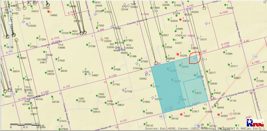
DOUBLE LEFT CLICK ON MAP TO ENLARGE
---
### Author:  [@system](https://www.mineralrightsforum.com/u/system)
#### Post date: [April 15, 2020, 3:17pm UTC](https://www.mineralrightsforum.com/t/section-12-block-32-township-1-north/54949/3 "2020-04-15T15:17:20Z")
This topic was automatically closed after 90 days. New replies are no longer allowed.