# Reeves County Drilling
**URL:** https://www.mineralrightsforum.com/t/reeves-county-drilling/3899
**Category:** General Mineral Rights Discussion
**Created:** [November 23, 2016, 7:44pm UTC](https://www.mineralrightsforum.com/t/reeves-county-drilling/3899 "2016-11-23T19:44:05Z")
**Posts on this page:** 6
**Page:** 1
### Author:  [@Arnold\_J\_Fernandes](https://www.mineralrightsforum.com/u/Arnold_J_Fernandes)
#### Post date: [November 23, 2016, 7:44pm UTC](https://www.mineralrightsforum.com/t/reeves-county-drilling/3899/1 "2016-11-23T19:44:05Z")
Looking for information on any drilling activity: Sections 13, 14, 20, 21, 22, 23, 28, 29 Block C-6, PSL Survey, Reeves County, Texas
Any information will be helpful, Thank you.
---
### Author:  [@Clint\_Liles](https://www.mineralrightsforum.com/u/Clint_Liles)
#### Post date: [November 24, 2016, 12:24am UTC](https://www.mineralrightsforum.com/t/reeves-county-drilling/3899/2 "2016-11-24T00:24:18Z")
Anna,
The last activity I see in the area of your minerals are the 7 or 8 permitted locations for horizontal wells in Section 21 going into Section 22. Those were approved in June and September 2016. I noticed some very good producers in your Section 23. One of the leases goes by the name Anna Katherine.
GIS Map of Reeves County Sections 13, 14, 20, 21, 22, 23, 28 and 29/Block C6 PSL and surrounding area:
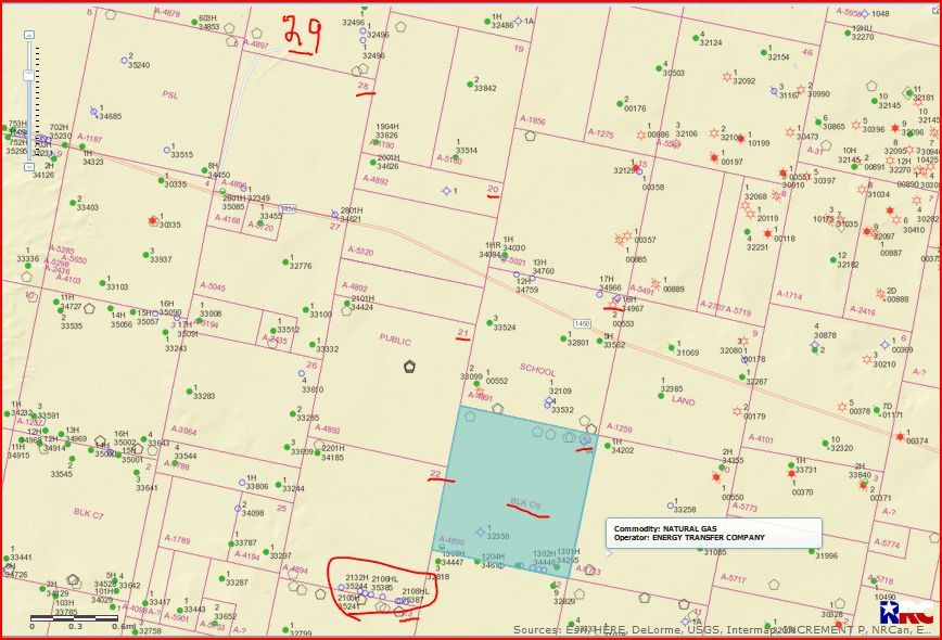CLICK ON MAP TO ENLARGE
---
### Author:  [@Arnold\_J\_Fernandes](https://www.mineralrightsforum.com/u/Arnold_J_Fernandes)
#### Post date: [November 24, 2016, 6:07pm UTC](https://www.mineralrightsforum.com/t/reeves-county-drilling/3899/3 "2016-11-24T18:07:41Z")
Thank you, that was a great help.
---
### Author:  [@James\_Marrow](https://www.mineralrightsforum.com/u/James_Marrow)
#### Post date: [November 25, 2016, 7:30pm UTC](https://www.mineralrightsforum.com/t/reeves-county-drilling/3899/4 "2016-11-25T19:30:19Z")
I believe this is in the Apache “find.” Not drilled yet to my knowledge. Landman representing Apache tried to lease from name for 500/acre, and we did not agree 🙂
---
### Author:  [@Richard\_Salazar](https://www.mineralrightsforum.com/u/Richard_Salazar)
#### Post date: [September 20, 2017, 6:49pm UTC](https://www.mineralrightsforum.com/t/reeves-county-drilling/3899/5 "2017-09-20T18:49:27Z")
Is there anything going on in SW/4 Section 44 Block 4?
---
### Author:  [@system](https://www.mineralrightsforum.com/u/system)
#### Post date: [August 14, 2018, 10:54pm UTC](https://www.mineralrightsforum.com/t/reeves-county-drilling/3899/6 "2018-08-14T22:54:56Z")