# Reeves County Blk 56 Sec 17, 18 PSL
**URL:** https://www.mineralrightsforum.com/t/reeves-county-blk-56-sec-17-18-psl/84369
**Category:** Ownership and Title
**Created:** [October 24, 2025, 3:15am UTC](https://www.mineralrightsforum.com/t/reeves-county-blk-56-sec-17-18-psl/84369 "2025-10-24T03:15:29Z")
**Posts on this page:** 5
**Page:** 1
### Author:  [@Tmac4600](https://www.mineralrightsforum.com/u/Tmac4600)
#### Post date: [October 24, 2025, 3:15am UTC](https://www.mineralrightsforum.com/t/reeves-county-blk-56-sec-17-18-psl/84369/1 "2025-10-24T03:15:29Z")
What are the distance requirements from our boundary for drilling a well? I believe a well has been drilled 30’ off the northern boundary of Section 18.
Any helpful comments would be appreciated.
---
### Author:  [@TennisDaze](https://www.mineralrightsforum.com/u/TennisDaze)
#### Post date: [October 24, 2025, 3:33am UTC](https://www.mineralrightsforum.com/t/reeves-county-blk-56-sec-17-18-psl/84369/2 "2025-10-24T03:33:36Z")
Rules vary by field and depth. For a horizontal wellbore, distance from section line parallel to horizontal wellbore is generally 330’ and the distance from the section line to first or last take point at each end is generally 100’. Look at the plat for the first take point, rather than at the drill site.
---
### Author:  [@Tmac4600](https://www.mineralrightsforum.com/u/Tmac4600)
#### Post date: [October 24, 2025, 3:54am UTC](https://www.mineralrightsforum.com/t/reeves-county-blk-56-sec-17-18-psl/84369/3 "2025-10-24T03:54:19Z")
Thank you for the assistance.
---
### Author:  [@NMoilboy](https://www.mineralrightsforum.com/u/NMoilboy)
#### Post date: [October 24, 2025, 2:36pm UTC](https://www.mineralrightsforum.com/t/reeves-county-blk-56-sec-17-18-psl/84369/4 "2025-10-24T14:36:15Z")
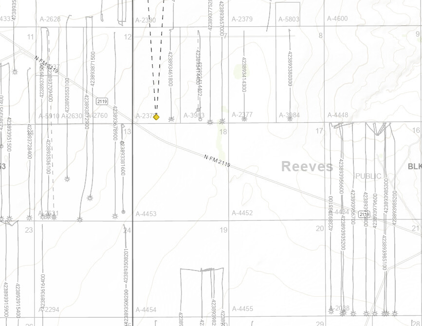
Curious what well you are talking about. If this is just north of FM 2119, VEP has permitted two wells that have FTP 330’ FSL of Section 7 (i.e., 330’ north of the Section 18 line). But no indication they have drilled those yet. Diamonds on map below. Maybe I’m just confused.
---
### Author:  [@system](https://www.mineralrightsforum.com/u/system)
#### Post date: [January 22, 2026, 3:15am UTC](https://www.mineralrightsforum.com/t/reeves-county-blk-56-sec-17-18-psl/84369/5 "2026-01-22T03:15:38Z")
This topic was automatically closed after 90 days. New replies are no longer allowed.