# Oil well location
**URL:** https://www.mineralrightsforum.com/t/oil-well-location/81205
**Category:** Murray County, OK
**Created:** [May 3, 2025, 7:45pm UTC](https://www.mineralrightsforum.com/t/oil-well-location/81205 "2025-05-03T19:45:51Z")
**Posts on this page:** 3
**Page:** 1
### Author:  [@Famous\_Tankersley1](https://www.mineralrightsforum.com/u/Famous_Tankersley1)
#### Post date: [May 3, 2025, 7:45pm UTC](https://www.mineralrightsforum.com/t/oil-well-location/81205/1 "2025-05-03T19:45:51Z")
Back in 2019 I purchased roughly 5 acres in Murray County. 4.5 acres in 36-1N-1E and .5 NMA in 31-1N-2E. In Section 36, I have S/2 SE/4 NE/4; NE/4 SE/4; E/2 NW/4 SE/4; and SW/4 NW/4 SE/4 of this 90 acres I have 4.5 NMA. In Section 31, I have S/2 NW/4 SW/4 Lot 3 being 39.93 acres which I have 0.5 NMA.
When I purchased this property I didn’t see any wells at the time but I liked the area. I paid to run title and have verified my ownership.
Last night, I got on Drilling Edge and discovered a well right there in the NE/4 of Section 36??? The Jake B1 a well operated by Bays Exploration? I really don’t see how I am not getting paid royalties for this well?? Can someone please check my figures? It looks to me like it’s right in that 90 Acres of Section 36 where I have 4.5 NMA??? I don’t know much about well spacing but it looks like it literally is sitting within that 90 acres???
I remember distinctly looking at Google Earth photos when I bought this parcel and never saw any wells? Now, there’s clearly a well pad and pumping unit there. However, the well data says the original completion date was 9/24/2009?? The satellite images I see on Drilling Edge show what appears to be a fairly new and large gravel pad?
Please help me confirm that well location on me. Also, how would I not have been notified or given a lease or division order? I’m also wondering if there was an old well there that was temporary abandoned and someone came in and worked it and started it back up?
---
### Author:  [@M\_Barnes](https://www.mineralrightsforum.com/u/M_Barnes)
#### Post date: [May 4, 2025, 1:51am UTC](https://www.mineralrightsforum.com/t/oil-well-location/81205/2 "2025-05-04T01:51:36Z")
The permit for Jake B 1-note that the well is a directional well starting fron the S2 of the NE corner and landing in the 80 spacing acres of the N2 NE4. I have marked your descriptions in the diagram (S/2 SE/4 NE/4; NE/4 SE/4; E/2 NW/4 SE/4; and SW/4 NW/4 SE/4). Your acreage is not included in the spacing of the well, so you do not receive royalties. You are looking at the correct pad. The well goes to the north.
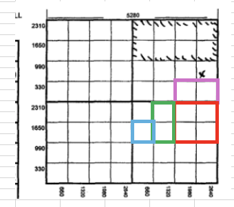
[https://public.occ.ok.gov/OGCDWellRecords/DocView.aspx?id=2756565&dbid=0&repo=OCC&searchid=f71a6786-7d50-4a3d-836b-89eb29616765](https://public.occ.ok.gov/OGCDWellRecords/DocView.aspx?id=2756565&dbid=0&repo=OCC&searchid=f71a6786-7d50-4a3d-836b-89eb29616765)
The completion for Jake B 1- [https://public.occ.ok.gov/OGCDWellRecords/DocView.aspx?id=3100593&dbid=0&repo=OCC&searchid=b7321166-760c-42ae-84e3-0a07bf62c88e](https://public.occ.ok.gov/OGCDWellRecords/DocView.aspx?id=3100593&dbid=0&repo=OCC&searchid=b7321166-760c-42ae-84e3-0a07bf62c88e)
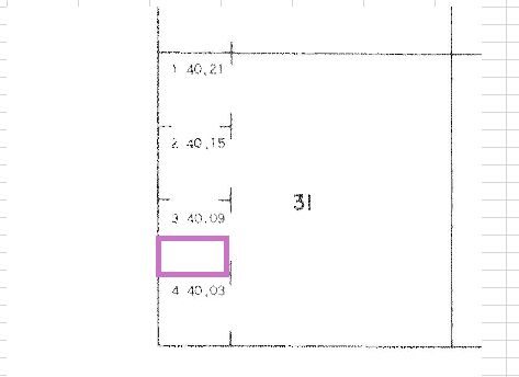
The Bureau of Land Management has Lot 3 of 31-1N-2E at 40.09 acres. I marked your portion of S/2 NW/4 SW/4
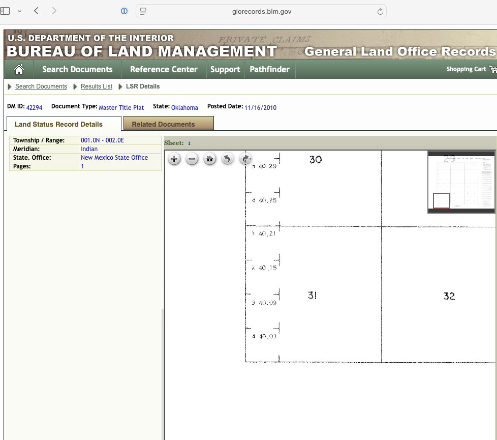. 
---
### Author:  [@system](https://www.mineralrightsforum.com/u/system)
#### Post date: [August 1, 2025, 7:45pm UTC](https://www.mineralrightsforum.com/t/oil-well-location/81205/3 "2025-08-01T19:45:54Z")
This topic was automatically closed after 90 days. New replies are no longer allowed.