# New Mineral Rights Owner
**URL:** https://www.mineralrightsforum.com/t/new-mineral-rights-owner/37453
**Category:** Reeves County, TX
**Created:** [November 27, 2018, 2:23am UTC](https://www.mineralrightsforum.com/t/new-mineral-rights-owner/37453 "2018-11-27T02:23:54Z")
**Posts on this page:** 6
**Page:** 1
### Author:  [@M\_B](https://www.mineralrightsforum.com/u/M_B)
#### Post date: [November 27, 2018, 2:23am UTC](https://www.mineralrightsforum.com/t/new-mineral-rights-owner/37453/1 "2018-11-27T02:23:54Z")
Hello all,
I recently inherited a share of the West 1/2 of Section 6, Block C8 in Reeves County. I am unsure of how to find out about activity in that area, and how to estimate what leasing offers are reasonable. Does anyone have any advice?
Best, May
---
### Author:  [@Clint\_Liles](https://www.mineralrightsforum.com/u/Clint_Liles)
#### Post date: [November 27, 2018, 3:50am UTC](https://www.mineralrightsforum.com/t/new-mineral-rights-owner/37453/2 "2018-11-27T03:50:10Z")
May, I can’t help you with leasing offers for the area but Apache and Upcurve Energy have 2 permitted locations in the area. Apache’s location is permitted for a 16,000’ Wolfcamp well (API 389-37446). Upcurve Energy permitted location is permitted for an 11,300’ Wolfcamp well (API 389-37176). Apache spud (begin drilling) October 08, 2018. Upcurve spud (begin drilling) August 11, 2018.
I find no completion report at this time for either of those wells.
[http://webapps2.rrc.state.tx.us/EWA/drillingPermitDetailAction.do?methodToCall=searchByUniversalDocNo&universalDocNo=491931049&rrcActionMan=H4sIAAAAAAAAAL1Qu27DMAz8mnQU9LBdd-BgBO2ctEEzGBkUW3AEyJZByWgL6ONLuyiQOp0z6Xg8HY9MgnOQSXAB4gGxqZpo\_fDaYFvzEyz8hznrcQySUZuFqKNh8ZNNYaOqkpNCwka-PB8rgmqGLVrn7NDtDPY2hv1k8OvHlrWeRBn0Jl58e\_Bb7RwROaCJEw4H\_2Y0NheiSuA3aeqwdCvsAhs16v5du8ksISmDKp\_UY5YVc5XD2XR2CEcbZzNy-1MLuaqv9aux4n5HCL\_LFzDqzuDVkv9eRJzqtW4OCyJJEDwpAhnwlNNbEHH7-y73\_AbGhC54YQIAAA](http://webapps2.rrc.state.tx.us/EWA/drillingPermitDetailAction.do?methodToCall=searchByUniversalDocNo&universalDocNo=491931049&rrcActionMan=H4sIAAAAAAAAAL1Qu27DMAz8mnQU9LBdd-BgBO2ctEEzGBkUW3AEyJZByWgL6ONLuyiQOp0z6Xg8HY9MgnOQSXAB4gGxqZpo_fDaYFvzEyz8hznrcQySUZuFqKNh8ZNNYaOqkpNCwka-PB8rgmqGLVrn7NDtDPY2hv1k8OvHlrWeRBn0Jl58e_Bb7RwROaCJEw4H_2Y0NheiSuA3aeqwdCvsAhs16v5du8ksISmDKp_UY5YVc5XD2XR2CEcbZzNy-1MLuaqv9aux4n5HCL_LFzDqzuDVkv9eRJzqtW4OCyJJEDwpAhnwlNNbEHH7-y73_AbGhC54YQIAAA)
I find a couple of older horizontal gas wells (with condensate) drilled by Chesapeake back in 2007-2008 still producing from the Toyah NW (shale).
GIS Map of Reeves County Section 6/Block C8 and surrounding area:
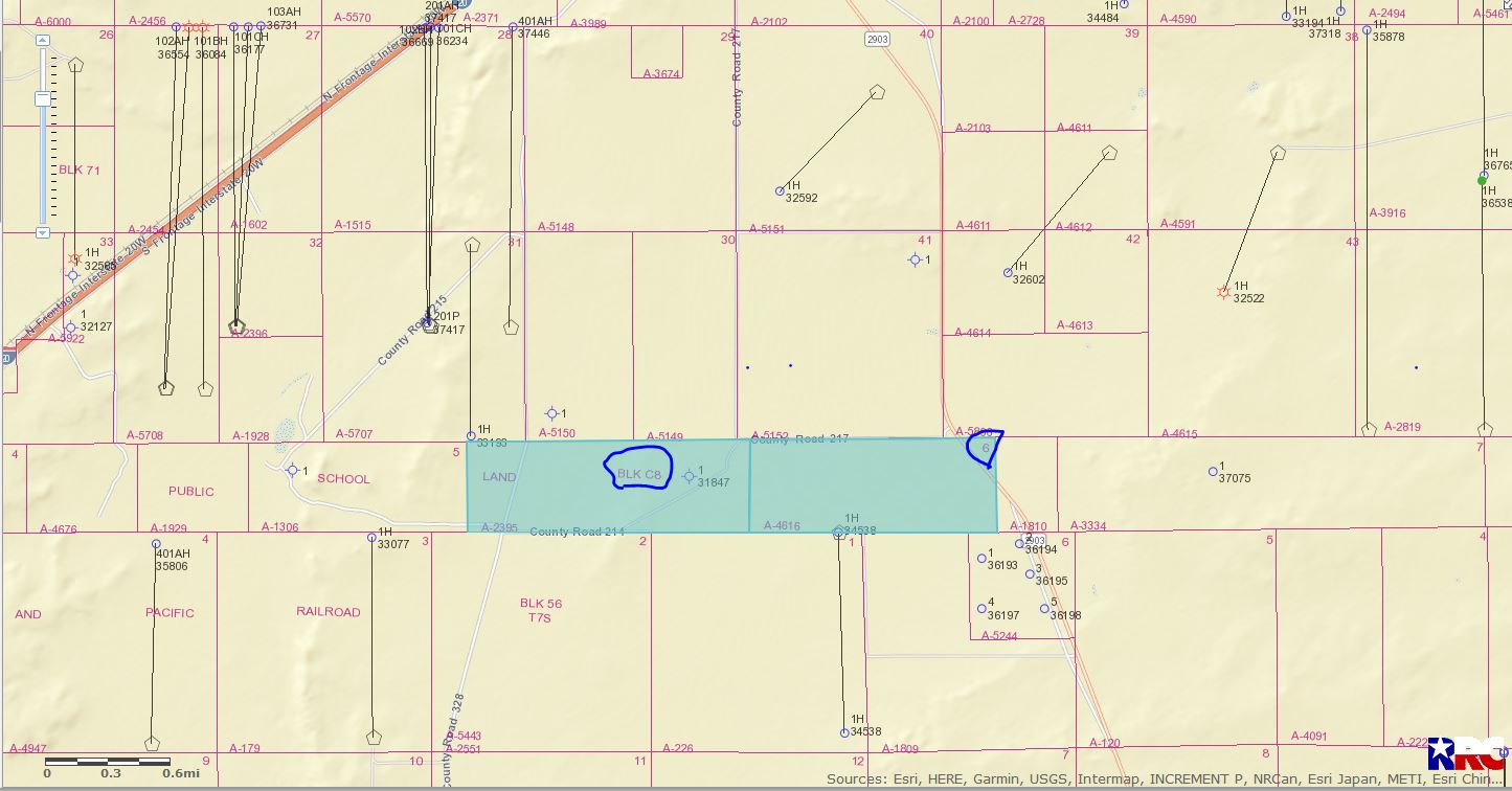
DOUBLE LEFT CLICK ON MAP TO ENLARGE
---
### Author:  [@M\_B](https://www.mineralrightsforum.com/u/M_B)
#### Post date: [November 28, 2018, 12:23am UTC](https://www.mineralrightsforum.com/t/new-mineral-rights-owner/37453/3 "2018-11-28T00:23:02Z")
Thank you, Clint, this is very helpful! I wouldn’t know where to begin to find this info on my own.
I have a couple of other questions, if you happen to know the answers!
I know that the current lease will be up in August. When the time comes to sign a new lease, do companies typically reach out to owners, or do owners reach out to companies?
Is there a way to know what activity is going on in the surrounding properties? Ideally, I want to be able to find what companies have wells, and where.
---
### Author:  [@Clint\_Liles](https://www.mineralrightsforum.com/u/Clint_Liles)
#### Post date: [November 28, 2018, 1:09am UTC](https://www.mineralrightsforum.com/t/new-mineral-rights-owner/37453/4 "2018-11-28T01:09:10Z")
Companies generally will contact you if and when they are interested in leasing your acreage. Although you need to make sure that your name and address are up to date with the Reeves County Clerk’s Office.
---
### Author:  [@Joy\_Roberts](https://www.mineralrightsforum.com/u/Joy_Roberts)
#### Post date: [December 1, 2018, 4:30pm UTC](https://www.mineralrightsforum.com/t/new-mineral-rights-owner/37453/5 "2018-12-01T16:30:20Z")
Clint, where do I go to look for completion reports? Are they on the RRC website?
---
### Author:  [@MRFAdmin\_SV](https://www.mineralrightsforum.com/u/MRFAdmin_SV)
#### Post date: [January 11, 2025, 5:08pm UTC](https://www.mineralrightsforum.com/t/new-mineral-rights-owner/37453/6 "2025-01-11T17:08:16Z")