# Need help with GIS viewer please
**URL:** https://www.mineralrightsforum.com/t/need-help-with-gis-viewer-please/61954
**Category:** Ownership and Title
**Created:** [May 31, 2021, 6:27pm UTC](https://www.mineralrightsforum.com/t/need-help-with-gis-viewer-please/61954 "2021-05-31T18:27:32Z")
**Posts on this page:** 5
**Page:** 1
### Author:  [@Mikro1TX](https://www.mineralrightsforum.com/u/Mikro1TX)
#### Post date: [May 31, 2021, 6:27pm UTC](https://www.mineralrightsforum.com/t/need-help-with-gis-viewer-please/61954/1 "2021-05-31T18:27:33Z")
Hello all,
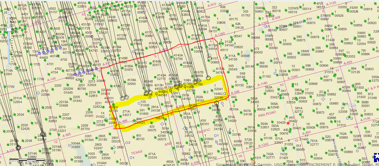
Hello All, I am trying to find these on the GIS viewer. I thought I was getting better at navigating it but I need some help please. See attached photo for Midland county, Not sure now what these entail? Maybe something else is what I need to use other than GIS viewer? BLK 37 T5S sections 4 and 5. What parts of these I am not sure? Thank you in advance, MK

---
### Author:  [@Donald\_Skotty](https://www.mineralrightsforum.com/u/Donald_Skotty)
#### Post date: [May 31, 2021, 7:35pm UTC](https://www.mineralrightsforum.com/t/need-help-with-gis-viewer-please/61954/2 "2021-05-31T19:35:10Z")
From the Texas RRC GIS site. Your sections are outlined in red, and the 228 acres in the south of each if roughly outlined in yellow. A lot of activity in the area with Parsley (now owned by Pioneer) and Pioneer:
---
### Author:  [@Mikro1TX](https://www.mineralrightsforum.com/u/Mikro1TX)
#### Post date: [May 31, 2021, 7:47pm UTC](https://www.mineralrightsforum.com/t/need-help-with-gis-viewer-please/61954/3 "2021-05-31T19:47:28Z")
Thank you very much for that info and picture. I suspected that was the case but could not confirm. Again many thanks Sir. Sincerely, Mike
---
### Author:  [@Tim\_Martinez](https://www.mineralrightsforum.com/u/Tim_Martinez)
#### Post date: [June 2, 2021, 12:26am UTC](https://www.mineralrightsforum.com/t/need-help-with-gis-viewer-please/61954/4 "2021-06-02T00:26:23Z")
Hi Mike, you should be receiving checks on the Leo 8-5-A wells. The Zoey wells in section 4 were just permitted in May. Good luck, Tim.
---
### Author:  [@system](https://www.mineralrightsforum.com/u/system)
#### Post date: [August 29, 2021, 6:28pm UTC](https://www.mineralrightsforum.com/t/need-help-with-gis-viewer-please/61954/5 "2021-08-29T18:28:30Z")
This topic was automatically closed after 90 days. New replies are no longer allowed.