# Need help for my property in Ward county
**URL:** https://www.mineralrightsforum.com/t/need-help-for-my-property-in-ward-county/39239
**Category:** Ward County, TX
**Created:** [December 30, 2018, 6:08pm UTC](https://www.mineralrightsforum.com/t/need-help-for-my-property-in-ward-county/39239 "2018-12-30T18:08:32Z")
**Posts on this page:** 19
**Page:** 1
### Author:  [@Johntran](https://www.mineralrightsforum.com/u/Johntran)
#### Post date: [December 30, 2018, 6:08pm UTC](https://www.mineralrightsforum.com/t/need-help-for-my-property-in-ward-county/39239/1 "2018-12-30T18:08:32Z")
Hello everyone! I have another property at SE 1/4 of the NE of the NE of Section 60, Block 34, H&TC Rwy Co Survey, Ward County. Is anything going on there? I have no idea how to find the gas and oil there. Please help. Thank you.
---
### Author:  [@M\_Barnes](https://www.mineralrightsforum.com/u/M_Barnes)
#### Post date: [December 30, 2018, 6:18pm UTC](https://www.mineralrightsforum.com/t/need-help-for-my-property-in-ward-county/39239/2 "2018-12-30T18:18:01Z")
Which state please? Several of them have a Ward County.
---
### Author:  [@Johntran](https://www.mineralrightsforum.com/u/Johntran)
#### Post date: [December 30, 2018, 6:19pm UTC](https://www.mineralrightsforum.com/t/need-help-for-my-property-in-ward-county/39239/3 "2018-12-30T18:19:00Z")
Oh. In Ward County, State of Texas.
---
### Author:  [@M\_Barnes](https://www.mineralrightsforum.com/u/M_Barnes)
#### Post date: [December 30, 2018, 6:32pm UTC](https://www.mineralrightsforum.com/t/need-help-for-my-property-in-ward-county/39239/4 "2018-12-30T18:32:52Z")
Moved your question to Ward County, TX.
---
### Author:  [@Clint\_Liles](https://www.mineralrightsforum.com/u/Clint_Liles)
#### Post date: [December 30, 2018, 7:06pm UTC](https://www.mineralrightsforum.com/t/need-help-for-my-property-in-ward-county/39239/5 "2018-12-30T19:06:22Z")
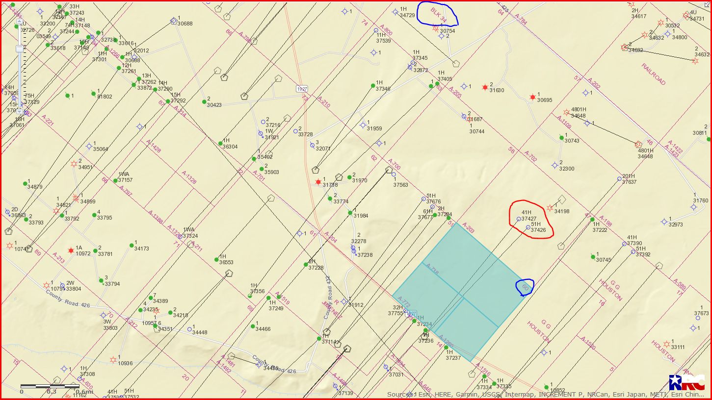
I see where Jagged Peak Energy has drilled 2 horizontal wells (API 475-37426 & 427) starting in Section 14/A-1494 and the wells end in Section 60. These wells are to the west of your minerals acreage.
Completion report shows well 37426 tested 1,220 barrels oil per day and 1,759,000 cubic feet gas per day.
Completion report shows well 37427 tested 1,223 barrels oil per day and 1,635,000 cubic feet gas per day.
[http://webapps.rrc.texas.gov/CMPL/viewPdfReportFormAction.do?method=cmplW2FormPdf&packetSummaryId=202244](http://webapps.rrc.texas.gov/CMPL/viewPdfReportFormAction.do?method=cmplW2FormPdf&packetSummaryId=202244)
[http://webapps.rrc.texas.gov/CMPL/viewPdfReportFormAction.do?method=cmplW2FormPdf&packetSummaryId=202246](http://webapps.rrc.texas.gov/CMPL/viewPdfReportFormAction.do?method=cmplW2FormPdf&packetSummaryId=202246)
GIS Map of Ward County Section 60/Block 34 and surrounding area:
DOUBLE LEFT CLICK ON MAP TO ENLARGE
---
### Author:  [@Johntran](https://www.mineralrightsforum.com/u/Johntran)
#### Post date: [December 30, 2018, 9:23pm UTC](https://www.mineralrightsforum.com/t/need-help-for-my-property-in-ward-county/39239/6 "2018-12-30T21:23:23Z")
Thank you very much, you are very helpful.
---
### Author:  [@Johntran](https://www.mineralrightsforum.com/u/Johntran)
#### Post date: [December 31, 2018, 4:04pm UTC](https://www.mineralrightsforum.com/t/need-help-for-my-property-in-ward-county/39239/7 "2018-12-31T16:04:31Z")
Hello Clint! I also own another 2 lots property at North-Half of the West-half of Section 277, Block 13, H&GN Railroad Company Survey, Reeves County. Is there any good news for my land? Thank you very much for your help. Johnny
---
### Author:  [@Clint\_Liles](https://www.mineralrightsforum.com/u/Clint_Liles)
#### Post date: [December 31, 2018, 8:04pm UTC](https://www.mineralrightsforum.com/t/need-help-for-my-property-in-ward-county/39239/8 "2018-12-31T20:04:44Z")
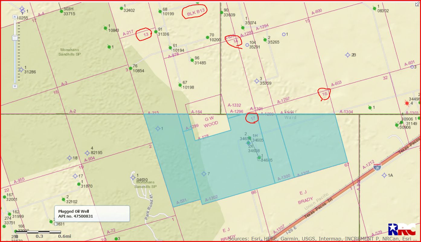
Johnny, I find Block B13 but no Section 277. In Block B13 I find a Section 13, 14, 16, and 17. Recheck your legal description.
DOUBLE LEFT CLICK ON MAP TO ENLARGE
Clint Liles
---
### Author:  [@Johntran](https://www.mineralrightsforum.com/u/Johntran)
#### Post date: [December 31, 2018, 8:40pm UTC](https://www.mineralrightsforum.com/t/need-help-for-my-property-in-ward-county/39239/9 "2018-12-31T20:40:32Z")
Thank you very much Clint
---
### Author:  [@Linton\_Tomlin](https://www.mineralrightsforum.com/u/Linton_Tomlin)
#### Post date: [December 31, 2018, 8:42pm UTC](https://www.mineralrightsforum.com/t/need-help-for-my-property-in-ward-county/39239/10 "2018-12-31T20:42:38Z")
Clint, you misread, I believe. Block 13, Section 277 is over on the North border of Block 52. Happy New Year!! Linton
---
### Author:  [@Clint\_Liles](https://www.mineralrightsforum.com/u/Clint_Liles)
#### Post date: [December 31, 2018, 8:47pm UTC](https://www.mineralrightsforum.com/t/need-help-for-my-property-in-ward-county/39239/11 "2018-12-31T20:47:37Z")
Thanks My Friend Linton, I’ll check it out…
HAPPY NEW YEAR AND MANY MORE IN YOUR LIFETIME
Clint Liles
---
### Author:  [@Johntran](https://www.mineralrightsforum.com/u/Johntran)
#### Post date: [December 31, 2018, 9:35pm UTC](https://www.mineralrightsforum.com/t/need-help-for-my-property-in-ward-county/39239/12 "2018-12-31T21:35:04Z")
So I am not in this map Clint
---
### Author:  [@Clint\_Liles](https://www.mineralrightsforum.com/u/Clint_Liles)
#### Post date: [December 31, 2018, 9:56pm UTC](https://www.mineralrightsforum.com/t/need-help-for-my-property-in-ward-county/39239/13 "2018-12-31T21:56:35Z")
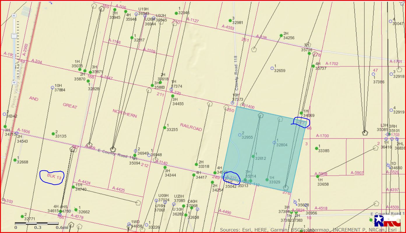
Reeves County Section 277/Block 13/A-327
Johnny/Linton…What threw me was that I assumed it was in Ward County…shame on me …I didn’t read closely enough at the full description…this location is actually in Reeves County. Some very good oil/gas wells in this area. Some of the major operators in this area are Noble Energy, Centennial Resources, Oxy USA WTP, NBL Permian LLC, and Atlantic Exploration LLC.
GIS Map of Reeves County Section 277/Block 13/A-327 and surrounding area:
DOUBLE LEFT CLICK TO ENLARGE MAP
Clint Liles
---
### Author:  [@Johntran](https://www.mineralrightsforum.com/u/Johntran)
#### Post date: [December 31, 2018, 10:00pm UTC](https://www.mineralrightsforum.com/t/need-help-for-my-property-in-ward-county/39239/14 "2018-12-31T22:00:12Z")
Thank you very much Clint, your information is very helpful to figure out around my property
---
### Author:  [@Johntran](https://www.mineralrightsforum.com/u/Johntran)
#### Post date: [January 5, 2019, 6:01am UTC](https://www.mineralrightsforum.com/t/need-help-for-my-property-in-ward-county/39239/15 "2019-01-05T06:01:46Z")
Hello Clint! Can you please give me more detail about mineral rights in Culberson County? Too many posted in here which is very confusing to me. The landowner has the property there and he pays annual tax every year (county tax and appraisal tax). If said mineral rights belong to the state, and the state also has a right to lease the property to any oil and gas companies, what’s the right of the landowner? And what does the landowner pay the appraisal for? And county tax? Thank you very much.
---
### Author:  [@Johntran](https://www.mineralrightsforum.com/u/Johntran)
#### Post date: [January 7, 2019, 8:55pm UTC](https://www.mineralrightsforum.com/t/need-help-for-my-property-in-ward-county/39239/16 "2019-01-07T20:55:29Z")
So any activity on my property yet?
---
### Author:  [@Johntran](https://www.mineralrightsforum.com/u/Johntran)
#### Post date: [January 8, 2019, 1:55am UTC](https://www.mineralrightsforum.com/t/need-help-for-my-property-in-ward-county/39239/17 "2019-01-08T01:55:33Z")
Hello Clint, are there any activities in my section yet? Based on the map you provided, I see the pipelines running over my lot (Lot 13 and Lot 18) of Section 277, Block 13 A/327. Thank you.
---
### Author:  [@Johntran](https://www.mineralrightsforum.com/u/Johntran)
#### Post date: [January 8, 2019, 5:11pm UTC](https://www.mineralrightsforum.com/t/need-help-for-my-property-in-ward-county/39239/18 "2019-01-08T17:11:13Z")
Hello Clint, These are the legal descriptions provided to me by the deeds regarding my two parcels:
+/- 5.10 acre tract of land out of the North Half of the West Half of Section 277, Block 13, H&GN Railroad Company Survey, Reeves County, Texas. Lot 13.
+/- 5.21 acre tract of land out of the North Half of the West Half of Section 277, Block 13, H&GN Railroad Company Survey, Reeves County, Texas. Lot 18.
---
### Author:  [@MRFAdmin\_SV](https://www.mineralrightsforum.com/u/MRFAdmin_SV)
#### Post date: [January 11, 2025, 4:53pm UTC](https://www.mineralrightsforum.com/t/need-help-for-my-property-in-ward-county/39239/19 "2025-01-11T16:53:22Z")