# Mineral lease
**URL:** https://www.mineralrightsforum.com/t/mineral-lease/12066
**Category:** Young County, TX
**Created:** [December 27, 2013, 2:20pm UTC](https://www.mineralrightsforum.com/t/mineral-lease/12066 "2013-12-27T14:20:56Z")
**Posts on this page:** 17
**Page:** 1
### Author:  [@Taylor3](https://www.mineralrightsforum.com/u/Taylor3)
#### Post date: [December 27, 2013, 2:20pm UTC](https://www.mineralrightsforum.com/t/mineral-lease/12066/1 "2013-12-27T14:20:56Z")
Received a lease the other day for $150 per acre about 10 miles outside of Graham, TX. I took that as a slap in the face as far as what things are leasing for these days, you folks agree? Thanks for any help.
---
### Author:  [@Carolyn\_Turner\_Raymond\_Turner](https://www.mineralrightsforum.com/u/Carolyn_Turner_Raymond_Turner)
#### Post date: [December 27, 2013, 6:26pm UTC](https://www.mineralrightsforum.com/t/mineral-lease/12066/2 "2013-12-27T18:26:07Z")
Are you north ,east. west or south of graham. I am about 4 to 5 miles north west of Murray . I got $ 300.00 a a/c about a year and a half ago and a 1/5 and a 3 year lease. I am on the young and Throckmorton county line. hope this helped
---
### Author:  [@Taylor3](https://www.mineralrightsforum.com/u/Taylor3)
#### Post date: [December 27, 2013, 6:28pm UTC](https://www.mineralrightsforum.com/t/mineral-lease/12066/3 "2013-12-27T18:28:36Z")
North of Graham near Loving, in area of intersection of hwy 114 and hwy 16
---
### Author:  [@Carolyn\_Turner\_Raymond\_Turner](https://www.mineralrightsforum.com/u/Carolyn_Turner_Raymond_Turner)
#### Post date: [December 27, 2013, 9:29pm UTC](https://www.mineralrightsforum.com/t/mineral-lease/12066/4 "2013-12-27T21:29:05Z")
Who was the company wanting to lease? do you know how to get on the Texas railroad web site? if so you can go on there site and pull up the permit in your abstract or around you and see if any drilling going on and who is leasing.
---
### Author:  [@N\_Rouse](https://www.mineralrightsforum.com/u/N_Rouse)
#### Post date: [January 4, 2014, 6:42pm UTC](https://www.mineralrightsforum.com/t/mineral-lease/12066/5 "2014-01-04T18:42:12Z")
Three to four years ago, we had so many offers to lease and it seems like the offers have slowed and, like Taylor has experienced, offers lowered. Carolyn, our land is two miles east of Murray, and the most we’ve ever been offered is $150/acre.
---
### Author:  [@Clint\_Liles](https://www.mineralrightsforum.com/u/Clint_Liles)
#### Post date: [January 5, 2014, 12:29am UTC](https://www.mineralrightsforum.com/t/mineral-lease/12066/6 "2014-01-05T00:29:41Z")
N Rouse,
If you will give me your Abstract # I will pull up your area on the RR Commission GIS Map and see what wells are in your area. I will post the map here for you.
Clint Liles
---
### Author:  [@N\_Rouse](https://www.mineralrightsforum.com/u/N_Rouse)
#### Post date: [January 5, 2014, 2:50pm UTC](https://www.mineralrightsforum.com/t/mineral-lease/12066/7 "2014-01-05T14:50:46Z")
Taylor, I believe that you want to send your abstract number to Clint. I know the wells in my area, including one recently drilled on one of my leases, but was just commenting on the slowing and lower price of lease offers.
---
### Author:  [@N\_Rouse](https://www.mineralrightsforum.com/u/N_Rouse)
#### Post date: [January 5, 2014, 3:09pm UTC](https://www.mineralrightsforum.com/t/mineral-lease/12066/8 "2014-01-05T15:09:19Z")
Clint, I would be interested in any activity in the area of Section 8, 12 or Section 13, A-1285, in the Young County School Land Survey.
---
### Author:  [@Clint\_Liles](https://www.mineralrightsforum.com/u/Clint_Liles)
#### Post date: [January 5, 2014, 7:00pm UTC](https://www.mineralrightsforum.com/t/mineral-lease/12066/9 "2014-01-05T19:00:46Z")
N Rouse,
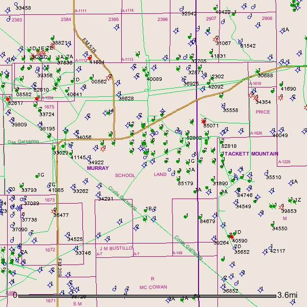
After checking the GIS Map I see a lot of plugged oil wells, some dry holes and a few still producing in A-1285.
For instance API 503-41145 (oil well) (Lease name-McKinley-Rush) was drilled in 2002 and was reentered in April 2012 by Brower Oil and Gas Co. Am posting a copy of GIS Map of A-1285 and surrounding area. My opinion is I would be asking for more than $150 per acre. On this map the green dots with green slash through them are plugged oil wells. The blue circles with 4 blue protrusions are dry holes. The blue circles are permitted locations. The green dots are producing oil wells.
Clint Liles
---
### Author:  [@Carolyn\_Turner\_Raymond\_Turner](https://www.mineralrightsforum.com/u/Carolyn_Turner_Raymond_Turner)
#### Post date: [January 6, 2014, 2:50am UTC](https://www.mineralrightsforum.com/t/mineral-lease/12066/10 "2014-01-06T02:50:38Z")
N Rouse my lease is in A 1085 north of you. NADEL GUSSMAN PERMIN LLC HAS 2 Permits to drill in A 965 called Thunder 965 and Thunder 965 2h. They also have another permit to drill another horizontal, a little further down from the Thunders. Do you know where Carmack Rd is off FM 578? That’s where the Permits are. My Lease is in A 1085 in Young County and A 717 and 718 in Throckmorton with North Texas Oil and Gas out of Edmond, OK. Most of the local companies are offering around $150.00 an acre and 3/16. I don’t know where Nadel Gussman is out of.
---
### Author:  [@Taylor3](https://www.mineralrightsforum.com/u/Taylor3)
#### Post date: [January 6, 2014, 2:34pm UTC](https://www.mineralrightsforum.com/t/mineral-lease/12066/11 "2014-01-06T14:34:16Z")
Hi Clint,
The stuff we have is in abstract A-1022 and A-1027, it’s Nytex Energy Holdings wanting to lease. I sent a letter back asking for $200 per acre, we’ll see what happens.
---
### Author:  [@Carolyn\_Turner\_Raymond\_Turner](https://www.mineralrightsforum.com/u/Carolyn_Turner_Raymond_Turner)
#### Post date: [January 7, 2014, 12:13am UTC](https://www.mineralrightsforum.com/t/mineral-lease/12066/12 "2014-01-07T00:13:41Z")
Taylor back in December 2010 NTX ENERGY LLC offered me $50.00 ac 3 yr paid up 3/16 and 2 YEAR renewal option. My cousin leased to them and I didn’t and in 2012 I got $300.00 and a 1/5. I have tried to find where they have ever drilled a well but can’t find any. If they are wanting a 2 year option I would bet they are trying to sell it off to somebody else. I would ask Clint to see if he can find anything on them. Raymond
---
### Author:  [@Clint\_Liles](https://www.mineralrightsforum.com/u/Clint_Liles)
#### Post date: [January 7, 2014, 12:56am UTC](https://www.mineralrightsforum.com/t/mineral-lease/12066/13 "2014-01-07T00:56:10Z")
Taylor,
You may want to check out this link: Scroll down to Nytex Energy…
> **[130328.mbx](http://bankrupt.com/TCR_Public/130328.mbx)**
---
### Author:  [@Clint\_Liles](https://www.mineralrightsforum.com/u/Clint_Liles)
#### Post date: [January 7, 2014, 1:23am UTC](https://www.mineralrightsforum.com/t/mineral-lease/12066/14 "2014-01-07T01:23:45Z")
Taylor,
In A-1022 & A-1027 I see numerous plugged oil wells, dry holes, and some producing oil wells. In A-1027 on the GIS Map shows a red circle with several red protrusions from it. That is supposed to be a gas well. When I pulled the Approved Permit API # 503-34772 it shows a Dry Hole (oil Well). DUH–it shows to be a gas well but the permit says dry hole oil well. Am posting the GIS Map of Young County A-1022 & A-1027:
![GIS Map]()
Taylor, This is the drilling permit link for the so-called gas well in A-1027 that turns out to be a dry hole oil well:
> **[W1 Search](http://webapps.rrc.state.tx.us/DP/drillDownQueryAction.do?fromPublicQuery=Y&name=MCCLURE&univDocNo=173902)**
---
### Author:  [@Clint\_Liles](https://www.mineralrightsforum.com/u/Clint_Liles)
#### Post date: [January 7, 2014, 1:35am UTC](https://www.mineralrightsforum.com/t/mineral-lease/12066/15 "2014-01-07T01:35:11Z")
Taylor,
Personally I would be very leery about signing any kind of lease with this Nytex Energy. Just my opinion.
> **[filename1.pdf](https://www.sec.gov/Archives/edgar/data/1475899/000000000013045714/filename1.pdf)**
>
> 112.78 KB
---
### Author:  [@Taylor3](https://www.mineralrightsforum.com/u/Taylor3)
#### Post date: [January 7, 2014, 3:16pm UTC](https://www.mineralrightsforum.com/t/mineral-lease/12066/16 "2014-01-07T15:16:47Z")
Clint,
I do appreciate all of your help and advice on this deal, we’ll see if I hear from them again after asking for the $200 per acre. Also, the return envelope I sent my counter offer back in was not Nytex, it was some company out of Weatherford, Texas. It was initials, ADL maybe, probably not it, or something like that. I’ll do plenty more research if I do hear back from them, I appreciate everyone’s help on this.
---
### Author:  [@system](https://www.mineralrightsforum.com/u/system)
#### Post date: [August 15, 2018, 1:03am UTC](https://www.mineralrightsforum.com/t/mineral-lease/12066/17 "2018-08-15T01:03:32Z")