# Mineral Interest Location
**URL:** https://www.mineralrightsforum.com/t/mineral-interest-location/60662
**Category:** Scurry County, TX
**Created:** [February 17, 2021, 5:56pm UTC](https://www.mineralrightsforum.com/t/mineral-interest-location/60662 "2021-02-17T17:56:32Z")
**Posts on this page:** 8
**Page:** 1
### Author:  [@Ryan\_Bevans](https://www.mineralrightsforum.com/u/Ryan_Bevans)
#### Post date: [February 17, 2021, 5:56pm UTC](https://www.mineralrightsforum.com/t/mineral-interest-location/60662/1 "2021-02-17T17:56:32Z")
Where is Section 98 Block 3 H&TC Ry Co Survey Scurry County, Texas? Is it worth anything?
---
### Author:  [@PeteR](https://www.mineralrightsforum.com/u/PeteR)
#### Post date: [February 17, 2021, 10:55pm UTC](https://www.mineralrightsforum.com/t/mineral-interest-location/60662/2 "2021-02-17T22:55:33Z")
Hi Ryan, This area is also known as A-1533 & A-2656. It is about 1 mile north of Hermleigh, Texas, east of US Hwy 84 between County roads 4102 and 4104. Area around Latitude 32.6647N and Longitude 100.7602W. There are no active wells on the land at the moment, but the surrounding sections have active producing wells.
---
### Author:  [@Clint\_Liles](https://www.mineralrightsforum.com/u/Clint_Liles)
#### Post date: [February 19, 2021, 12:57am UTC](https://www.mineralrightsforum.com/t/mineral-interest-location/60662/3 "2021-02-19T00:57:58Z")
Ryan after close examination I find 2 Section 98/Block 3 in Scurry County… After checking this GIS Map can you tell which one your acreage will be in? Do you own the minerals, the surface or both?
??? Section 98/Block 3 A-2605/A-2684/A-2809/A-2919
??? Section 98/Block 3 A-1533/A-2656
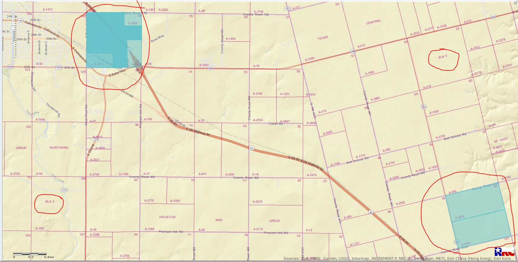
LEFT CLICK ON MAP TO ENLARGE
---
### Author:  [@PeteR](https://www.mineralrightsforum.com/u/PeteR)
#### Post date: [February 19, 2021, 1:49am UTC](https://www.mineralrightsforum.com/t/mineral-interest-location/60662/4 "2021-02-19T01:49:39Z")
Hi Clint - You had me worried for a minute, but there is a subtle difference. A-1533 and A-2656 are in the H&TC survey, while the others are in the H & GN survey. Kind of confusing since they are relatively close together.
---
### Author:  [@Clint\_Liles](https://www.mineralrightsforum.com/u/Clint_Liles)
#### Post date: [February 19, 2021, 3:30am UTC](https://www.mineralrightsforum.com/t/mineral-interest-location/60662/5 "2021-02-19T03:30:48Z")
Ha… didn’t even notice that… yes, you are right… thanks for the correction.
---
### Author:  [@AJ11](https://www.mineralrightsforum.com/u/AJ11)
#### Post date: [February 19, 2021, 4:09am UTC](https://www.mineralrightsforum.com/t/mineral-interest-location/60662/6 "2021-02-19T04:09:47Z")
[**This link**](http://gis.rrc.texas.gov/GISViewer/index.html?api=41535395) will open an RRC GIS map on a producing well in Section 95 which adjoins Section 96. Said well has produced almost 100,000 barrels of oil. Use the zoom bar on the left-hand side of the map to move out two or three clicks for better visualization.
**Were you made aware of your ownership by an unknown third party who is wanting to purchase your interest?** How many mineral acres do you own? If you had ten acres included in a 320-acre drilling unit with a 25% royalty lease which truly did not allow any deductions, then 100,000 b/o production would pay you around $40,000 in royalties assuming $50 oil were realized. But the neighboring well has not stopped producing, and its estimated ultimate recovery could be hard to come by.
This assumes that your land can be drilled and produced similarly and does not have geological problems. Perhaps someone much more knowledgeable about oil and gas on this forum will weigh in with any needed corrections to the above.
Do you know if any of the minerals in your section have been leased? Do you know the names of any of the other mineral owners? If so, you might try to find leases by doing a free search on TexasFile or CourtHouseDirect.
---
### Author:  [@Linda\_Beason](https://www.mineralrightsforum.com/u/Linda_Beason)
#### Post date: [February 20, 2021, 4:20pm UTC](https://www.mineralrightsforum.com/t/mineral-interest-location/60662/7 "2021-02-20T16:20:55Z")
I am aware of all of the above and the minerals are leased.
---
### Author:  [@system](https://www.mineralrightsforum.com/u/system)
#### Post date: [May 18, 2021, 5:57pm UTC](https://www.mineralrightsforum.com/t/mineral-interest-location/60662/8 "2021-05-18T17:57:32Z")
This topic was automatically closed after 90 days. New replies are no longer allowed.