# Key Exploration Update - October 14, 2025
**URL:** https://www.mineralrightsforum.com/t/key-exploration-update-october-14-2025/84217
**Category:** Houston County, TX
**Created:** [October 14, 2025, 3:21pm UTC](https://www.mineralrightsforum.com/t/key-exploration-update-october-14-2025/84217 "2025-10-14T15:21:57Z")
**Posts on this page:** 9
**Page:** 1
### Author:  [@Alan\_Herrington](https://www.mineralrightsforum.com/u/Alan_Herrington)
#### Post date: [October 14, 2025, 3:21pm UTC](https://www.mineralrightsforum.com/t/key-exploration-update-october-14-2025/84217/1 "2025-10-14T15:21:58Z")
Back in April 2024, I posted that Key Exploration had been leasing acreage in the Ramon De La Garza Survey A-33 in Houston County. I continue to believe that Key has been leasing for Expand in Cherokee County, and I wondered if this Houston County leasing might also be for Expand.
At the time of my original post, I didn’t think to check for any deep vertical wells in the area that might be data sources for possible deep horizontal wells. However, I recently took a look.
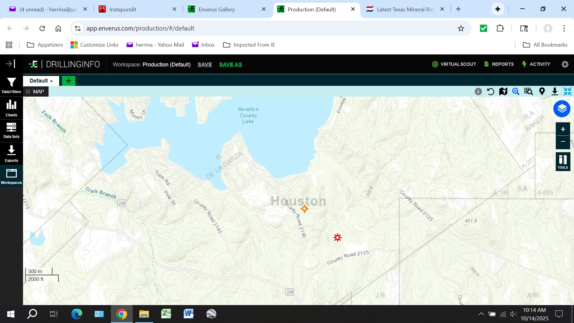
It turns out that Chesapeake (now named Expand) permitted two vertical wells to a TVD of 22,000 feet in the De La Garza Survey: McFaddin 1 and McFaddin 2. McFaddin 2 was only drilled to 7,270 feet and was completed in the Woodbine Sands. However, McFaddin 1 was drilled to 17,340 feet, with log data available to 16,200 feet. I was told that the log data showed the well was in Bossier Sands at that depth. Maximus later acquired the wellbore and made a completion in the Woodbine Sands at 7,000 feet.
Here’s a screenshot showing the location of the two McFaddin wells. McFaddin 1 is the one just above County Road 2135.
In this next screenshot, I’ve added Key Exploration’s lease area. As you can see, Key has leased what appears to be a ready-made horizontal well unit with the McFaddin 1 surface location right in the middle of it.
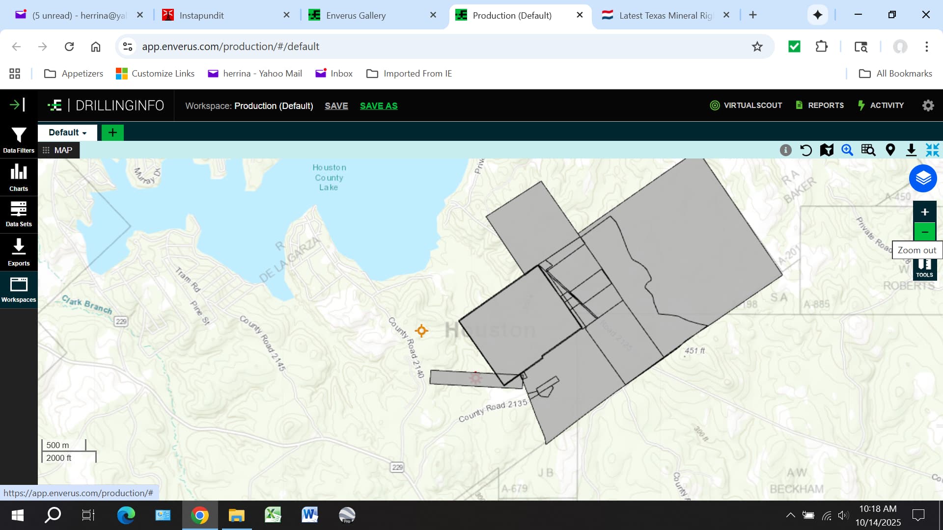
This suggests to me that the Key Exploration leasing is connected to Expand. Time will tell…
---
### Author:  [@Mineral\_Owner5](https://www.mineralrightsforum.com/u/Mineral_Owner5)
#### Post date: [October 15, 2025, 1:40am UTC](https://www.mineralrightsforum.com/t/key-exploration-update-october-14-2025/84217/2 "2025-10-15T01:40:40Z")
Maximus and Key Exploration are one and the same.
---
### Author:  [@r.cook75835](https://www.mineralrightsforum.com/u/r.cook75835)
#### Post date: [November 11, 2025, 1:22am UTC](https://www.mineralrightsforum.com/t/key-exploration-update-october-14-2025/84217/3 "2025-11-11T01:22:36Z")
Maximus purchased the McFaddin 1 and 2 from Chesapeake and then went and drilled further.
---
### Author:  [@r.cook75835](https://www.mineralrightsforum.com/u/r.cook75835)
#### Post date: [November 11, 2025, 1:23am UTC](https://www.mineralrightsforum.com/t/key-exploration-update-october-14-2025/84217/4 "2025-11-11T01:23:53Z")
Maximus also drilled Redtown 1 off of 2125 and it was a dry hole, but they stated they may go in and drill further.
---
### Author:  [@Mineral\_Owner5](https://www.mineralrightsforum.com/u/Mineral_Owner5)
#### Post date: [November 15, 2025, 8:49pm UTC](https://www.mineralrightsforum.com/t/key-exploration-update-october-14-2025/84217/5 "2025-11-15T20:49:29Z")
Maximus Operating (Key) just permitted an 8,000 ft. Woodbine well on 11/14/25 on the Texas RRC. It is south of the eastern side of Houston County Lake in the Ramon De La Garza Abstract 33 in Houston County. The Magnatar Latexo location is east of there about 5 or so miles.
---
### Author:  [@r.cook75835](https://www.mineralrightsforum.com/u/r.cook75835)
#### Post date: [November 16, 2025, 1:03am UTC](https://www.mineralrightsforum.com/t/key-exploration-update-october-14-2025/84217/6 "2025-11-16T01:03:12Z")
This is our place. Maximus is also doing one on the Marina Road at Houston County Lake.
---
### Author:  [@r.cook75835](https://www.mineralrightsforum.com/u/r.cook75835)
#### Post date: [November 16, 2025, 2:49am UTC](https://www.mineralrightsforum.com/t/key-exploration-update-october-14-2025/84217/7 "2025-11-16T02:49:22Z")
No this is McFaddin2 I believe.
---
### Author:  [@r.cook75835](https://www.mineralrightsforum.com/u/r.cook75835)
#### Post date: [December 5, 2025, 5:24am UTC](https://www.mineralrightsforum.com/t/key-exploration-update-october-14-2025/84217/9 "2025-12-05T05:24:12Z")
Landman said they named the well something else; I guess too many with the same name. Has new name, waiting on rig to arrive. Ours may not go in until February 2026 on Ramon de la Garza A-33.
---
### Author:  [@system](https://www.mineralrightsforum.com/u/system)
#### Post date: [March 5, 2026, 5:24am UTC](https://www.mineralrightsforum.com/t/key-exploration-update-october-14-2025/84217/10 "2026-03-05T05:24:26Z")
This topic was automatically closed 90 days after the last reply. New replies are no longer allowed.