# Info on Pooled unit
**URL:** https://www.mineralrightsforum.com/t/info-on-pooled-unit/70572
**Category:** Reeves County, TX
**Created:** [April 17, 2023, 11:07pm UTC](https://www.mineralrightsforum.com/t/info-on-pooled-unit/70572 "2023-04-17T23:07:01Z")
**Posts on this page:** 8
**Page:** 1
### Author:  [@DCole](https://www.mineralrightsforum.com/u/DCole)
#### Post date: [April 17, 2023, 11:07pm UTC](https://www.mineralrightsforum.com/t/info-on-pooled-unit/70572/1 "2023-04-17T23:07:01Z")
Couple of questions. Where would I look for description of a recently pooled unit in Reeves County? I have not been sent a copy but heard there is one. Can you pool a unit before it is drilled? Would appreciate hearing any other questions / answers that would help explain pooled unit.
---
### Author:  [@Dusty1](https://www.mineralrightsforum.com/u/Dusty1)
#### Post date: [April 18, 2023, 10:56am UTC](https://www.mineralrightsforum.com/t/info-on-pooled-unit/70572/2 "2023-04-18T10:56:39Z")
Railroad Commission’s GIS map is where to find drilling permits that have been approved by RRC. People sometimes refer to pooled units when they are really talking about the platted boundaries of a drilling unit an operator filed with their application for a permit to drill.
Here’s a link to RRC’s GIS map. The page includes a user’s guide and links to a training video on how to use the map. [https://www.rrc.texas.gov/resource-center/research/gis-viewer/](https://www.rrc.texas.gov/resource-center/research/gis-viewer/)
To see the unit plats for new permits that RRC hasn’t approved yet, here’s a link to the Permit Section on their site. [https://webapps2.rrc.texas.gov/EWA/drillingPermitsQueryAction.do](https://webapps2.rrc.texas.gov/EWA/drillingPermitsQueryAction.do)
---
### Author:  [@TennisDaze](https://www.mineralrightsforum.com/u/TennisDaze)
#### Post date: [April 18, 2023, 6:36pm UTC](https://www.mineralrightsforum.com/t/info-on-pooled-unit/70572/3 "2023-04-18T18:36:50Z")
If a proper unit is formed, the operator and non-op working interests will file a Designation of Pooled Unit (DPU) or similar document in County deed records. It should be recorded prior to drilling. If you post information on the location of your minerals and any permitted wells, you will get more feedback.
---
### Author:  [@DCole](https://www.mineralrightsforum.com/u/DCole)
#### Post date: [April 18, 2023, 11:00pm UTC](https://www.mineralrightsforum.com/t/info-on-pooled-unit/70572/4 "2023-04-18T23:00:43Z")
The pooled unit would include Block 50, Township 7, Section 37 and 38. Thanks.
---
### Author:  [@DCole](https://www.mineralrightsforum.com/u/DCole)
#### Post date: [April 18, 2023, 11:02pm UTC](https://www.mineralrightsforum.com/t/info-on-pooled-unit/70572/5 "2023-04-18T23:02:03Z")
And thank you Dusty for the links.
---
### Author:  [@TennisDaze](https://www.mineralrightsforum.com/u/TennisDaze)
#### Post date: [April 19, 2023, 1:33am UTC](https://www.mineralrightsforum.com/t/info-on-pooled-unit/70572/6 "2023-04-19T01:33:24Z")
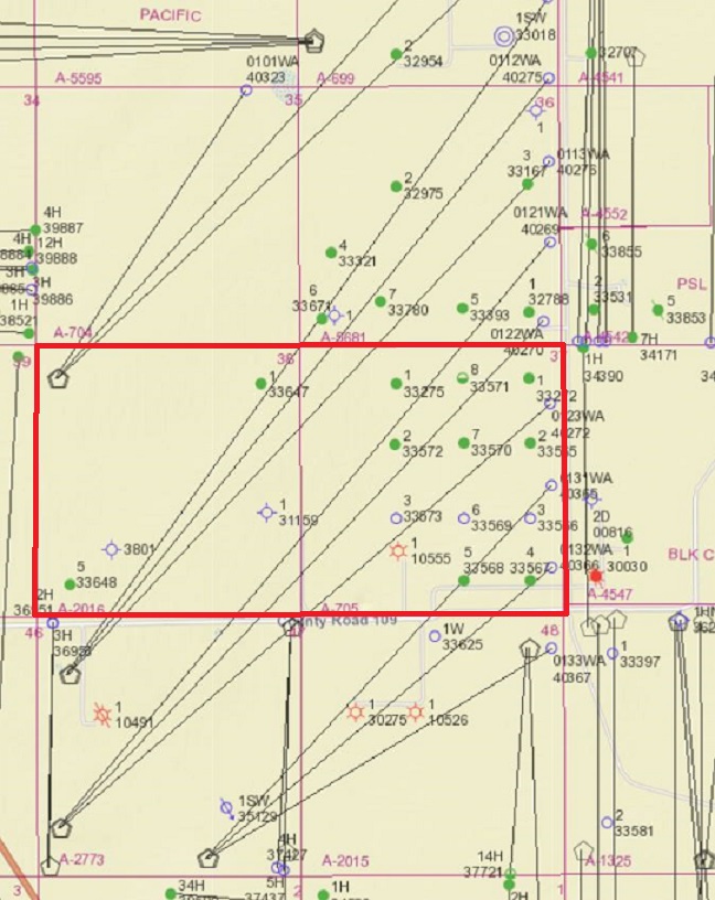
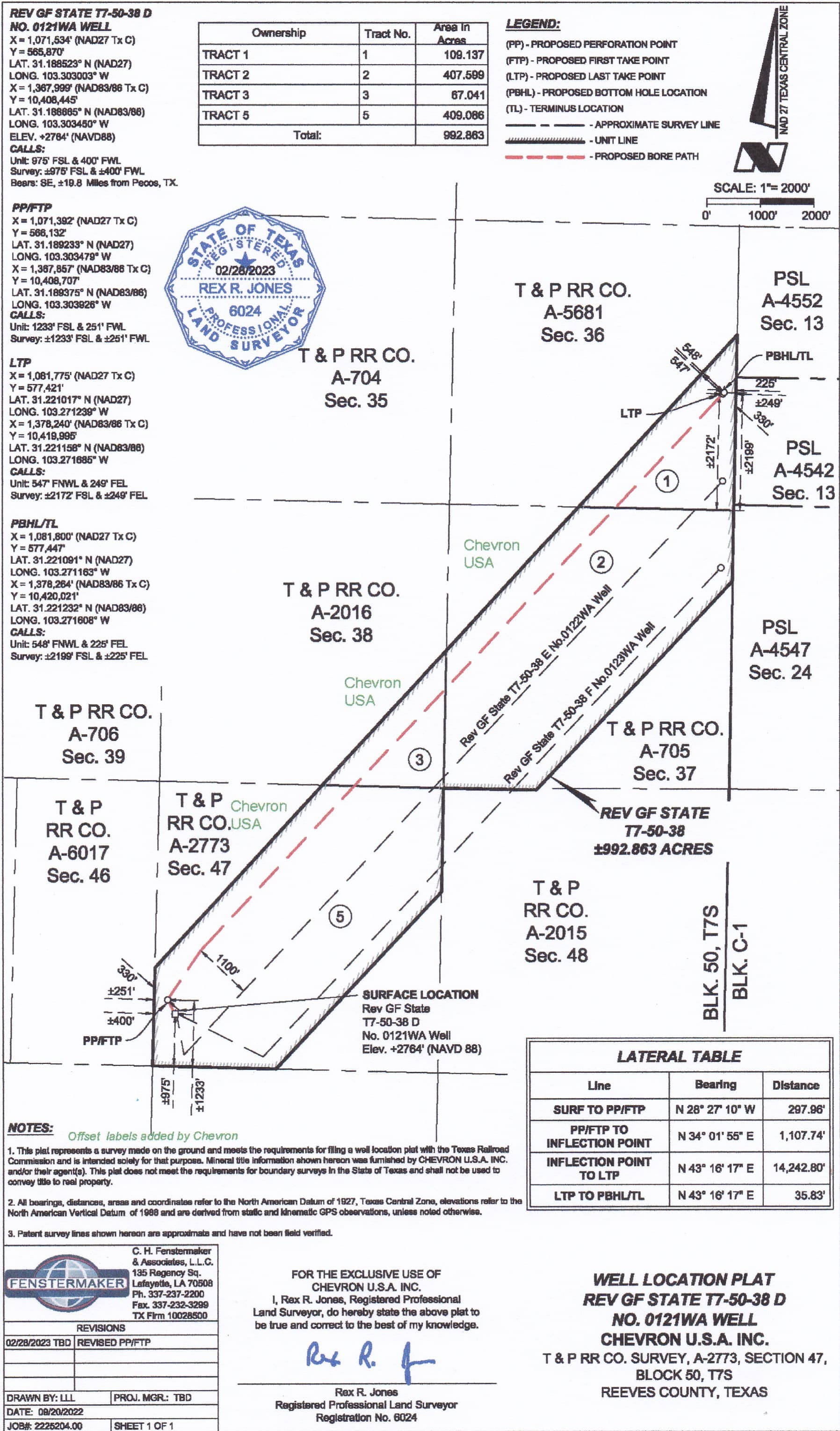
Chevron has filed permits for Rev GF State T7-50-38 wells which cross Section 37 and/or Section 38. These wells angle diagonally across several sections. Permits note that these are allocation wells and therefore units are not being formed. On the RRC permits page, select Reeves County, Chevron as operator and Rev GF State T7-50-38 as lease name and all the wells will appear. You can open the permits, plats, etc. for each well.
---
### Author:  [@Dusty1](https://www.mineralrightsforum.com/u/Dusty1)
#### Post date: [April 19, 2023, 2:01am UTC](https://www.mineralrightsforum.com/t/info-on-pooled-unit/70572/7 "2023-04-19T02:01:28Z")
To show you what some of the things TennisDaze described will look like, below are RRC’s current map of that area with Section 37 & 38 outlined, and the plat Chevron filed with RRC to permit the well they called the 38 D. That permit was approved last month so it might be the “new unit” you were hearing about, but most of the other wells Chevron has programmed crossing your two sections were approved last October or November.
---
### Author:  [@system](https://www.mineralrightsforum.com/u/system)
#### Post date: [July 16, 2023, 11:07pm UTC](https://www.mineralrightsforum.com/t/info-on-pooled-unit/70572/8 "2023-07-16T23:07:33Z")
This topic was automatically closed after 90 days. New replies are no longer allowed.