# Howard County Tx
**URL:** https://www.mineralrightsforum.com/t/howard-county-tx/41998
**Category:** Howard County, TX
**Created:** [February 21, 2019, 2:49pm UTC](https://www.mineralrightsforum.com/t/howard-county-tx/41998 "2019-02-21T14:49:38Z")
**Posts on this page:** 9
**Page:** 1
### Author:  [@poppachuck](https://www.mineralrightsforum.com/u/poppachuck)
#### Post date: [February 21, 2019, 2:49pm UTC](https://www.mineralrightsforum.com/t/howard-county-tx/41998/1 "2019-02-21T14:49:38Z")
Own mineral rights in Sections 47 & 48 in Howard County, Texas. In 2016 Rambo well 38-47B 9WA was drilled north of us. I received a division order and sent it back to S&M, soon received a check. One of my sisters received the same. My other sister did not; she called S&M and was told it was a mistake to have paid us. Visited with a cousin landowner next to us, he said them and another cousin land/mineral owner have been paid since 2016. What should I do to settle this issue? Thanks.
---
### Author:  [@TwoShoeBeagie7](https://www.mineralrightsforum.com/u/TwoShoeBeagie7)
#### Post date: [February 21, 2019, 3:48pm UTC](https://www.mineralrightsforum.com/t/howard-county-tx/41998/2 "2019-02-21T15:48:58Z")
We need more details to help. What reason did S&M give for the mistaken payment? Did they mess up during heirship research, or did they misinterpret a probate and/or deed?
---
### Author:  [@poppachuck](https://www.mineralrightsforum.com/u/poppachuck)
#### Post date: [May 21, 2019, 11:22pm UTC](https://www.mineralrightsforum.com/t/howard-county-tx/41998/3 "2019-05-21T23:22:01Z")
I’m not sure what to do next? Lawyer?
---
### Author:  [@poppachuck](https://www.mineralrightsforum.com/u/poppachuck)
#### Post date: [May 21, 2019, 11:25pm UTC](https://www.mineralrightsforum.com/t/howard-county-tx/41998/4 "2019-05-21T23:25:34Z")
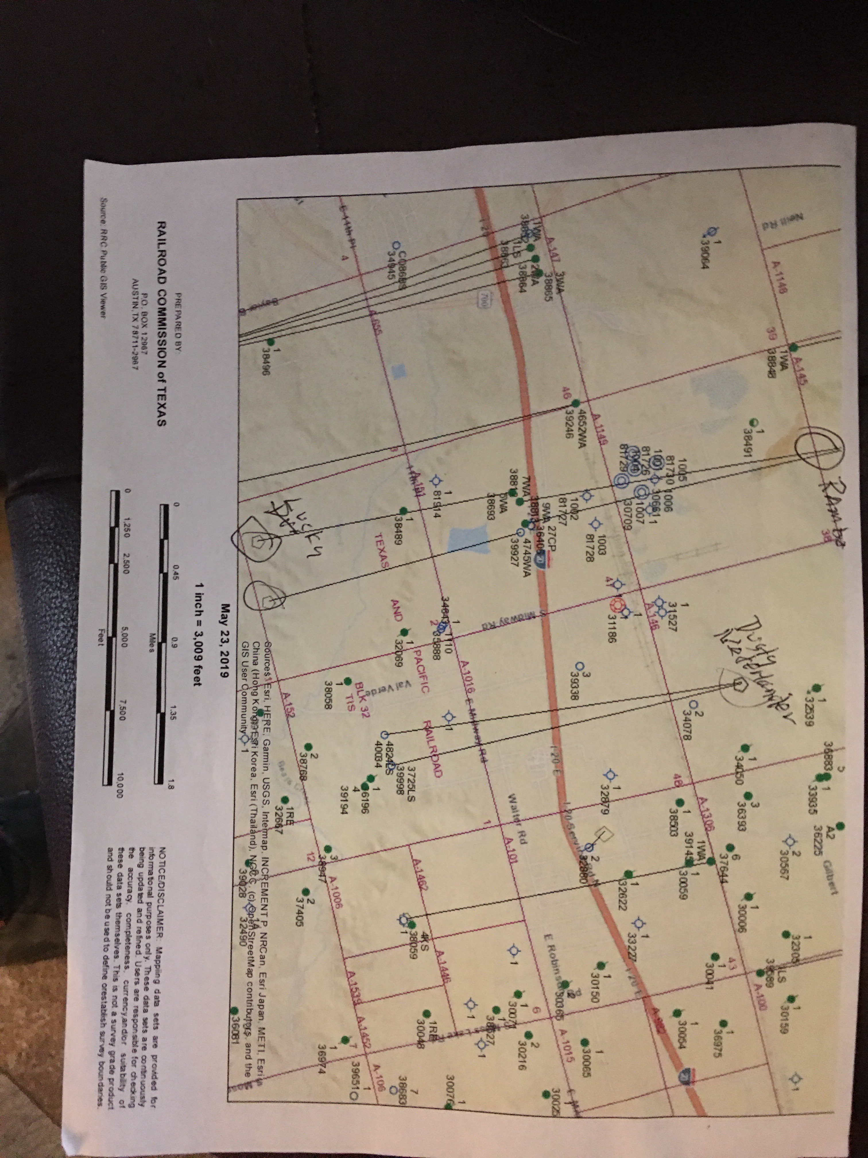
Please tell me where I can find a well map that shows the Section number, well location, and where the horizontal legs extend. Thanks.
---
### Author:  [@poppachuck](https://www.mineralrightsforum.com/u/poppachuck)
#### Post date: [October 5, 2019, 3:50pm UTC](https://www.mineralrightsforum.com/t/howard-county-tx/41998/5 "2019-10-05T15:50:51Z")
S&M has agreed to pay us back to January 1 of 2019, they have sent me a new division order. Why was my first division order not ok, and why don’t they have to pay me from May 2017? Date of first check was 4-24-17. Thanks.
---
### Author:  [@poppachuck](https://www.mineralrightsforum.com/u/poppachuck)
#### Post date: [November 28, 2019, 7:02pm UTC](https://www.mineralrightsforum.com/t/howard-county-tx/41998/6 "2019-11-28T19:02:02Z")
Section 47 and 48 we own a total of 40 acres give or take.
---
### Author:  [@poppachuck](https://www.mineralrightsforum.com/u/poppachuck)
#### Post date: [November 29, 2019, 4:13am UTC](https://www.mineralrightsforum.com/t/howard-county-tx/41998/7 "2019-11-29T04:13:48Z")
If 2 horizontal legs come under our Section, do all mineral owners in that Section get paid on both legs? Thanks
---
### Author:  [@Dusty1](https://www.mineralrightsforum.com/u/Dusty1)
#### Post date: [November 29, 2019, 7:33pm UTC](https://www.mineralrightsforum.com/t/howard-county-tx/41998/8 "2019-11-29T19:33:04Z")
In case you haven’t seen them, below is a link to plats showing the two Rambo wells you mentioned. Those drilling permits show both of them are allocation wells, which generally means you only receive royalties if the horizontal leg of the well actually crosses your land. It isn’t like a pooled unit that might include everything in a Section. Other factors can be involved, like production sharing agreements, so you’ll need to do some more checking. You might check the Howard County deed records to see if SM, or the original operator, filed a production sharing agreement or unit agreement involving those wells.
Since you said you are currently receiving royalties on the Rambo 38-47B, I’m assuming that lateral must cross the tract where your minerals are located. RRC’s production reports show that well started producing in December 2016 and is still producing. If you owned that mineral interest in 2016, it seems like you should have royalties coming from that point of first production forward.
[Howard County - SM Rambo 38-47 A and B.pdf](https://www.mineralrightsforum.com/uploads/short-url/qp11egu1RsNdWG09nbZtso44VRG.pdf) (1.1 MB)
---
### Author:  [@MRFAdmin\_SV](https://www.mineralrightsforum.com/u/MRFAdmin_SV)
#### Post date: [January 11, 2025, 5:31pm UTC](https://www.mineralrightsforum.com/t/howard-county-tx/41998/9 "2025-01-11T17:31:43Z")