# How to locate 40 acre site located in reeves county
**URL:** https://www.mineralrightsforum.com/t/how-to-locate-40-acre-site-located-in-reeves-county/8482
**Category:** Oil and Gas Leasing Help
**Created:** [November 13, 2014, 3:32am UTC](https://www.mineralrightsforum.com/t/how-to-locate-40-acre-site-located-in-reeves-county/8482 "2014-11-13T03:32:38Z")
**Posts on this page:** 13
**Page:** 1
### Author:  [@Richard\_P\_Lundahl](https://www.mineralrightsforum.com/u/Richard_P_Lundahl)
#### Post date: [November 13, 2014, 3:32am UTC](https://www.mineralrightsforum.com/t/how-to-locate-40-acre-site-located-in-reeves-county/8482/1 "2014-11-13T03:32:38Z")
Hi,
I am a newbie and don’t understand the mapping nomenclature of RRC GIS maps and the legend doesn’t seem to help me.
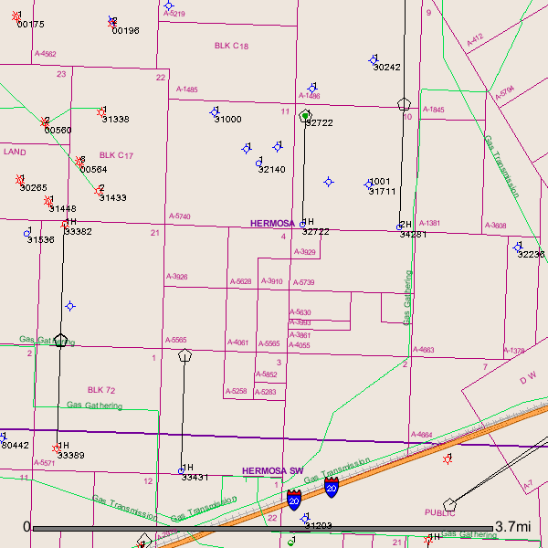
Can someone tell me where the 40 acres described as being in the Southeast Quarter (SE/4) of the Northeast Quarter (NE/4) of Section 4, Block C-18, A-3910, PSL survey, A-732, Reeves County, Texas is located.
Thanks in advance for your help.
---
### Author:  [@Clint\_Liles](https://www.mineralrightsforum.com/u/Clint_Liles)
#### Post date: [November 13, 2014, 4:20am UTC](https://www.mineralrightsforum.com/t/how-to-locate-40-acre-site-located-in-reeves-county/8482/2 "2014-11-13T04:20:53Z")
Hello Richard,
I tried pulling up this area on the RRC Public GIS Map Viewer (Legacy) but it is down for maintenance at this time. So I used the Enhanced Public GIS Viewer and I’m not so sure I like the looks of the map but here it is. When the other Map Viewer (Legacy) is back up and running I will get you a map with it.
GIS Map of Reeves County Section 4/A-3910/Block C18 and surrounding area:
Clint Liles
---
### Author:  [@AJ11](https://www.mineralrightsforum.com/u/AJ11)
#### Post date: [November 13, 2014, 4:22am UTC](https://www.mineralrightsforum.com/t/how-to-locate-40-acre-site-located-in-reeves-county/8482/3 "2014-11-13T04:22:06Z")
The Texas RRC has two online map viewers, the Legacy viewer and the Enhanced viewer. The Enhanced viewer has some neat features, but I do not know how to search by abstract numbers using it. On the other hand, searching by abstract number is supported by the Legacy viewer. Click on this URL [http://gis2.rrc.state.tx.us/public/](http://gis2.rrc.state.tx.us/public/)
Click “Accept.”
On the opened page near the bottom right side click on the “Abstract/Survey” button.
Then choose “Reeves” County from the drop-down box and then try filling in with your abstract numbers and searching. If all goes well, a map should open with your section/abstract centered.
The Legacy viewer is not working for me tonight.
PS If you choose to search by Block, do not include the hyphen, use only “C18”.
---
### Author:  [@Clint\_Liles](https://www.mineralrightsforum.com/u/Clint_Liles)
#### Post date: [November 13, 2014, 4:27am UTC](https://www.mineralrightsforum.com/t/how-to-locate-40-acre-site-located-in-reeves-county/8482/4 "2014-11-13T04:27:48Z")
AJ,
I have been told that the RR Commission is working on getting the new ‘Enhanced’ Viewer fixed so in the future we will be able to find locations by Abstract, Block, and Section numbers. It will be easier to use that’s for sure but I don’t care for the looks of the map features as they are so dim.
Clint Liles
---
### Author:  [@Richard\_P\_Lundahl](https://www.mineralrightsforum.com/u/Richard_P_Lundahl)
#### Post date: [November 13, 2014, 5:28am UTC](https://www.mineralrightsforum.com/t/how-to-locate-40-acre-site-located-in-reeves-county/8482/5 "2014-11-13T05:28:56Z")
Thanks Clint. I have tried the RRC GIS map viewer but had no luck. As you say, it must be down for maintenance.
Clint Liles said:
Hello Richard,
I tried pulling up this area on the RRC Public GIS Map Viewer (Legacy) but it is down for maintenance at this time. So I used the Enhanced Public GIS Viewer and I’m not so sure I like the looks of the map but here it is. When the other Map Viewer (Legacy) is back up and running I will get you a map with it.
GIS Map of Reeves Section 4/A-3910/Block C18 and surrounding area:
Clint Liles
---
### Author:  [@Richard\_P\_Lundahl](https://www.mineralrightsforum.com/u/Richard_P_Lundahl)
#### Post date: [November 13, 2014, 5:34am UTC](https://www.mineralrightsforum.com/t/how-to-locate-40-acre-site-located-in-reeves-county/8482/6 "2014-11-13T05:34:51Z")
Not sure how this reply works and if my thanks to AJ and Clint got through.
Thank you both. Will be happy to see the new enhanced GIS maps.
AJ said:
The RRC has two viewers, the Legacy viewer and the Enhanced viewer. The Enhanced viewer has some neat features, but I do not know how to search by abstract numbers using it. On the other hand, searching by abstract number is supported by the Legacy viewer. Click on this URL [http://gis2.rrc.state.tx.us/public/](http://gis2.rrc.state.tx.us/public/)
“Accept.”
On the opened page near the bottom right side click on the “Abstract/Survey” button.
Then choose “Reeves” County from the drop-down box and then try filling in with your abstract numbers and searching. If all goes well, a map should open with your section/abstract centered.
The Legacy viewer is not working for me tonight.
PS If you choose to search by Block, do not include the hyphen, use only “C18”.
---
### Author:  [@Clint\_Liles](https://www.mineralrightsforum.com/u/Clint_Liles)
#### Post date: [November 13, 2014, 5:04pm UTC](https://www.mineralrightsforum.com/t/how-to-locate-40-acre-site-located-in-reeves-county/8482/7 "2014-11-13T17:04:04Z")
Richard,
This is the Legacy GIS map of your Reeves County A-3910 and surrounding area. This link is to the completion report on a well (API 389-32722) to the N/E of your A-3910. This well has since been recompleted in 2013.
[http://webapps.rrc.state.tx.us/CMPL/viewPdfReportFormAction.do?method=cmplW2FormPdf&packetSummaryId=23748](http://webapps.rrc.state.tx.us/CMPL/viewPdfReportFormAction.do?method=cmplW2FormPdf&packetSummaryId=23748)
---
### Author:  [@Lea\_Scalf](https://www.mineralrightsforum.com/u/Lea_Scalf)
#### Post date: [May 13, 2015, 9:57pm UTC](https://www.mineralrightsforum.com/t/how-to-locate-40-acre-site-located-in-reeves-county/8482/8 "2015-05-13T21:57:16Z")
My sister & I, and our cousins have Abstract 3929 in the Northeast corner of Section 5. Below Well 32722.
Our 3-year lease expired last summer June 2014, and we were not contacted to renew the lease.
Any idea of recent activity in the area?
---
### Author:  [@April\_Aguilar\_CDOA](https://www.mineralrightsforum.com/u/April_Aguilar_CDOA)
#### Post date: [May 14, 2015, 5:19am UTC](https://www.mineralrightsforum.com/t/how-to-locate-40-acre-site-located-in-reeves-county/8482/9 "2015-05-14T05:19:39Z")
Lea, are you sure that your lease is not held by production from the 32722 well? What is the spacing for that well? If your lease is not a part of the well’s spacing/designation then that well may determine your future. For instance, if the well was what we call a “test well” and ended up being a dry hole or marginally producing, they may not opt to renew your lease - especially given the hard times in the industry right now. It never hurts to call your Lessee and ask about the status of the lease.
---
### Author:  [@Lea\_Scalf](https://www.mineralrightsforum.com/u/Lea_Scalf)
#### Post date: [May 14, 2015, 3:23pm UTC](https://www.mineralrightsforum.com/t/how-to-locate-40-acre-site-located-in-reeves-county/8482/10 "2015-05-14T15:23:08Z")
Thanks April. I have no idea if our NMA in A-3929 (Section 5, Block C-18) could be included in Well 32722?
No one has contacted us about anything since the original signing of our lease in 2011.
I’m also not 100% sure who holds our lease now, as it was originally signed with KEW Drilling, which then transferred to PetroHawk, and then I understand BHP acquired PetroHawk. So I assume BHP. 🙂
How can I research Well 32722 spacing?
Thank you,
---
### Author:  [@April\_Aguilar\_CDOA](https://www.mineralrightsforum.com/u/April_Aguilar_CDOA)
#### Post date: [May 15, 2015, 3:18am UTC](https://www.mineralrightsforum.com/t/how-to-locate-40-acre-site-located-in-reeves-county/8482/11 "2015-05-15T03:18:51Z")
Hi Lea, I would start by calling BHP and asking about the status of your lease. Sometimes royalty owners slip through the cracks when operating rights change hands that many times. I’m curious what you find out. 🙂
---
### Author:  [@Lea\_Scalf](https://www.mineralrightsforum.com/u/Lea_Scalf)
#### Post date: [May 15, 2015, 11:27am UTC](https://www.mineralrightsforum.com/t/how-to-locate-40-acre-site-located-in-reeves-county/8482/12 "2015-05-15T11:27:37Z")
Thanks April. I’ll do that. 🙂 I assumed with the decline in oil prices, that’s why they didn’t renew our lease last year, but you never know.
---
### Author:  [@system](https://www.mineralrightsforum.com/u/system)
#### Post date: [August 15, 2018, 12:06am UTC](https://www.mineralrightsforum.com/t/how-to-locate-40-acre-site-located-in-reeves-county/8482/13 "2018-08-15T00:06:20Z")