# How many wells pertain to my land
**URL:** https://www.mineralrightsforum.com/t/how-many-wells-pertain-to-my-land/75117
**Category:** Martin County, TX
**Created:** [April 8, 2024, 3:01pm UTC](https://www.mineralrightsforum.com/t/how-many-wells-pertain-to-my-land/75117 "2024-04-08T15:01:32Z")
**Posts on this page:** 11
**Page:** 1
### Author:  [@Rick5](https://www.mineralrightsforum.com/u/Rick5)
#### Post date: [April 8, 2024, 3:01pm UTC](https://www.mineralrightsforum.com/t/how-many-wells-pertain-to-my-land/75117/1 "2024-04-08T15:01:32Z")
Hello Y’all,
We leased a mineral interest last year in Martin County. XTO is drilling a plethora of wells on the acreage involved. We own an interest in Section 36, Block 36, Township 2N in the N/80 acres of the NW/4. T&P Ry. Co. Survey.
Question I have is XTO is drilling the HILL units A and B wells. Can anyone please tell me out of the number of wells drilled that XTO has spud in the last several months, how many pertain to the N/80 acres of the NW/4?
I’m hoping a production sharing agreement results from this interest as the drilling involves three separate sections in the same Block and Survey.
Any help would be greatly appreciated.
---
### Author:  [@Mikro1TX](https://www.mineralrightsforum.com/u/Mikro1TX)
#### Post date: [April 8, 2024, 3:45pm UTC](https://www.mineralrightsforum.com/t/how-many-wells-pertain-to-my-land/75117/2 "2024-04-08T15:45:33Z")
@Rick5, This should be the area you are in. 🙂 MK
---
### Author:  [@NMoilboy](https://www.mineralrightsforum.com/u/NMoilboy)
#### Post date: [April 8, 2024, 7:19pm UTC](https://www.mineralrightsforum.com/t/how-many-wells-pertain-to-my-land/75117/3 "2024-04-08T19:19:43Z")
“Well, you told me I have a plethora. And I just would like to know if you know what a plethora is. I would not like to think that a person would tell someone he has a plethora, and then find out that that person has _no idea_ what it means to have a plethora”.
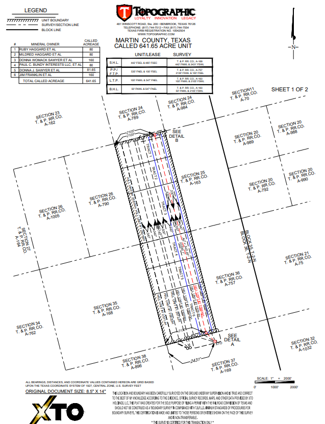
That should be the Hill 1 unit. (W2 of Section 36 and Section 25) They have spud 7 wells there total. Rigs are still there, would assume they will drill the last 2 wells (of the 9 Hill 1 permits) also.
It’s 2 sections. The SHL/pad is in Section 37 but your unit is the +/-640 acres that is the W2 of Section 36 and 25. You’ll get your share of whatever you own in that 641.65 acres.
---
### Author:  [@AJ11](https://www.mineralrightsforum.com/u/AJ11)
#### Post date: [April 8, 2024, 7:20pm UTC](https://www.mineralrightsforum.com/t/how-many-wells-pertain-to-my-land/75117/4 "2024-04-08T19:20:57Z")
Check out the RRC’s wells spudded data realization resource:
> [@Texas RRC Permitted and Spudded Wells Maps](https://www.mineralrightsforum.com/t/texas-rrc-permitted-and-spudded-wells-maps/72451):
>
> These Texas RRC data accessibility tools are new to me even though it looks like they may have been introduced several years ago. The [Approved Permitted Wells data visualization resource](https://www.rrc.texas.gov/resource-center/data-visualization/oil-gas-data-visualization/drilling-permits/) webpage allows one to find permitted wells and have them projected on a map. In the attached screenshot, Andrews County is the chosen area with all the wells permitted by Elevation Resources in the year 2023 shown. The same county, timeframe, and operator are shown in the screenshot from the [Wells Spudded data…](https://www.rrc.texas.gov/resource-center/data-visualization/oil-gas-data-visualization/wells-spudded/)
---
### Author:  [@Rick5](https://www.mineralrightsforum.com/u/Rick5)
#### Post date: [April 11, 2024, 3:18pm UTC](https://www.mineralrightsforum.com/t/how-many-wells-pertain-to-my-land/75117/5 "2024-04-11T15:18:20Z")
Hi NMoilboy,
Thanks for the info. The interest owned is 1/4 of 1/4 in the N/80 acres of Section 36. We have an interest in the two vertical Jones wells drilled there years ago. Over a 1.5% royalty interest. Get a lot of offers to purchase this interest. Not interested. Again, thanks for the info.
---
### Author:  [@Rick5](https://www.mineralrightsforum.com/u/Rick5)
#### Post date: [April 12, 2024, 5:44pm UTC](https://www.mineralrightsforum.com/t/how-many-wells-pertain-to-my-land/75117/6 "2024-04-12T17:44:42Z")
Using your acreage figure I’ve come up with the following royalty decimal interest. Please correct me if I’m wrong, as math is not my forte:
1/16 divided by 1/4 x 80/641.65 = .001948 x 7 wells = 1.3636%
---
### Author:  [@NMoilboy](https://www.mineralrightsforum.com/u/NMoilboy)
#### Post date: [April 15, 2024, 3:26am UTC](https://www.mineralrightsforum.com/t/how-many-wells-pertain-to-my-land/75117/7 "2024-04-15T03:26:11Z")
I think they will drill 9 wells total. You should have .00195 in each of them.
---
### Author:  [@Rick5](https://www.mineralrightsforum.com/u/Rick5)
#### Post date: [April 18, 2024, 11:26am UTC](https://www.mineralrightsforum.com/t/how-many-wells-pertain-to-my-land/75117/8 "2024-04-18T11:26:30Z")
XTO or Exxon is a great company for us. I for one am glad it’s XTO doing the drilling for this lease, and who will most likely distribute the revenue. We have several ventures with XTO in Pecos County, the Gunpowder wells, and in Lea County, New Mexico. The James Ranch and Poker Lake units.
Hope they drill all 9 wells!
---
### Author:  [@Caroline\_Brady](https://www.mineralrightsforum.com/u/Caroline_Brady)
#### Post date: [May 24, 2024, 4:34pm UTC](https://www.mineralrightsforum.com/t/how-many-wells-pertain-to-my-land/75117/9 "2024-05-24T16:34:43Z")
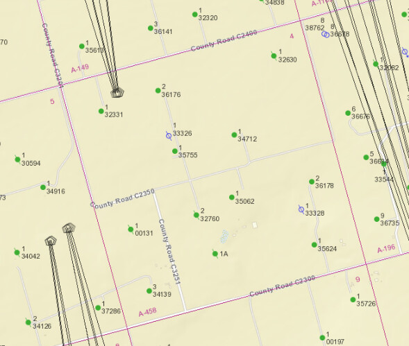
Same question slightly different location
Sec. 4, Block 36, Township 1 South – Martin County, Texas (Bowlin & Flanagan Lease)
---
### Author:  [@LanaStraub](https://www.mineralrightsforum.com/u/LanaStraub)
#### Post date: [May 24, 2024, 4:59pm UTC](https://www.mineralrightsforum.com/t/how-many-wells-pertain-to-my-land/75117/10 "2024-05-24T16:59:23Z")
There are quite a few vertical wells, depending on where you are in the section. It doesn’t look like there are any horizontals yet. Keep in mind that the RRC viewer is usually 3-6 months behind actual permits.
---
### Author:  [@system](https://www.mineralrightsforum.com/u/system)
#### Post date: [July 7, 2024, 3:02pm UTC](https://www.mineralrightsforum.com/t/how-many-wells-pertain-to-my-land/75117/11 "2024-07-07T15:02:04Z")
This topic was automatically closed after 90 days. New replies are no longer allowed.