Inherited royalty interest in Lea County. Family does not have any information about the interest. Trying to find out if any wells are located on the following property.
19S-37E-31 NW
19S-37E-31 NE
19S-37E-31 SW
20S-37E-6 NW
20S-36E-1 NE
Above details are all the information I have found. This dates back to 1922 and Lea County Courthouse “online” documents only date back to 2013 at this time.
Our family has some minerals iin Sections 22 & 23, T20S, R35E that are being exploited by Mewborne Energy. The wells were drilled in the mid to late 'sixties to the Bone Springs interval verticly. I think your property is probably close to ours and if so is not on the Central Basin Platform but in the Delaware Basin.
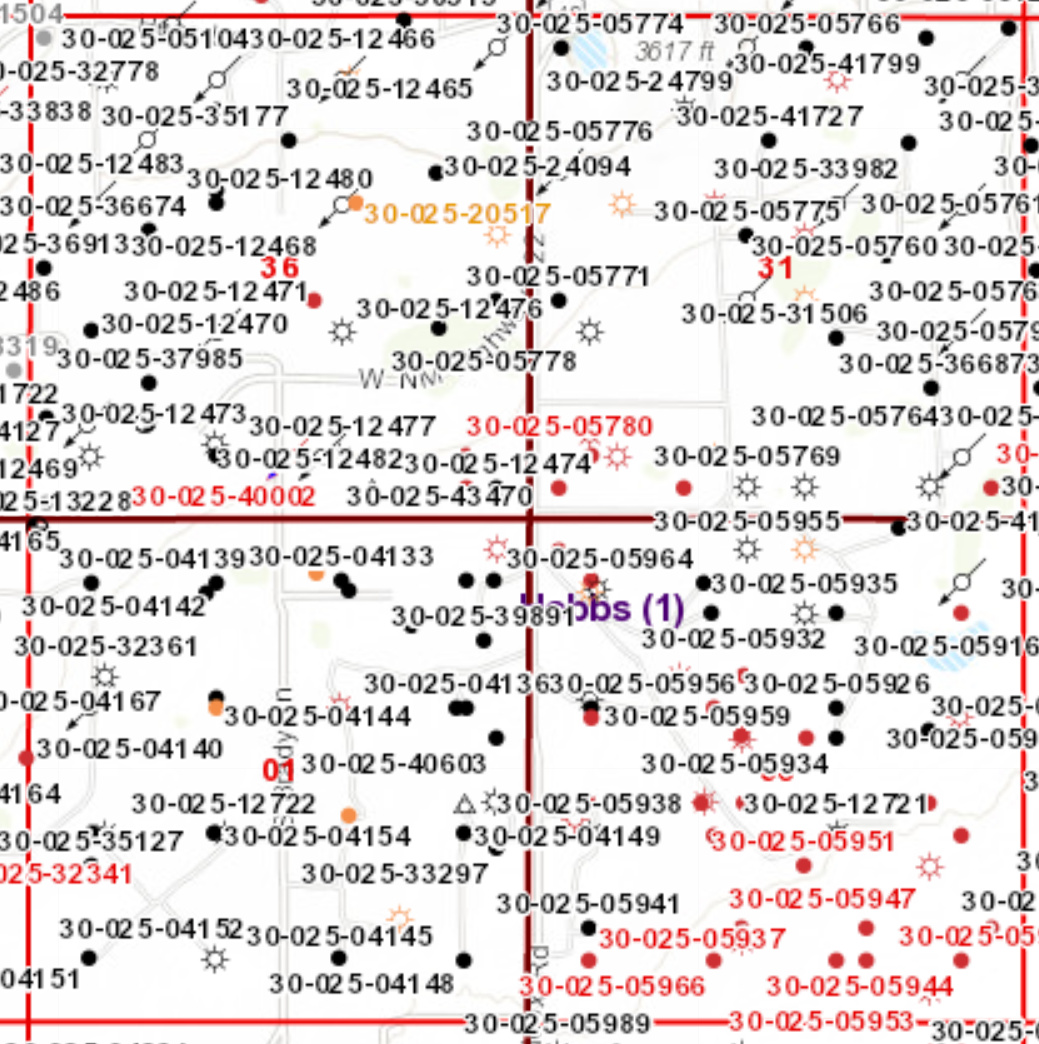
These lands are located on the northern tip of what’s called the Central Basin Platform which is the middle ridge of the Permian Basin. This is one of the “older” producing areas as most of the wells are shallow vertical wells. You can view New Mexico’s oil and gas map here to check on well activity. As you can see below, there are a lot of wells located on these lands. If your family is entitled to an interest, it could be held in suspense or have been turned over to unclaimed property. You could start by inquiring of the operators of the wells (looks like this area is predominantly Apache Corporation). You could also search the unclaimed property records of the state where the last owner of record resided.
Look in the “scanned index”.
You can get the older docs , just takes more work. You have to find the Book and Page info for the Lea County clerks office , then they can send you a copy. They are nice people. Email works well.
Two ways to search, by the grantor (direct) or grantee (indirect). The records are in bunches by various year periods. Quite often an oil company (Texaco oil) will have a section all to themselves. You have to look thru a number of pages but it works. I found that scanning the list looking at township or section to be fastest, you can miss things. There is a large section at the end of each year bunch for “USA” (as grantor), since a lot of the land is gov owned. The gov sometimes (always?) kept the mineral rights
when they issued a patent. Maybe you can look at glorecords.blm.gov. and find something.
You might want to start with the 1917 stuff. Having a name will help. For intance: I found info in that area for an “agreement” between CC Fristoe and Texas Production CO. . Fristoe was wanting to have TPC exploit the land he had a prospecting permit on. The agreement was from 1927.