# Help Finding Blk 1 Sec 9 Pecos Cnty
**URL:** https://www.mineralrightsforum.com/t/help-finding-blk-1-sec-9-pecos-cnty/40462
**Category:** Pecos County, TX
**Created:** [January 22, 2019, 12:33am UTC](https://www.mineralrightsforum.com/t/help-finding-blk-1-sec-9-pecos-cnty/40462 "2019-01-22T00:33:05Z")
**Posts on this page:** 6
**Page:** 1
### Author:  [@Daniel\_White1](https://www.mineralrightsforum.com/u/Daniel_White1)
#### Post date: [January 22, 2019, 12:33am UTC](https://www.mineralrightsforum.com/t/help-finding-blk-1-sec-9-pecos-cnty/40462/1 "2019-01-22T00:33:05Z")
Before my eyes go totally out of focus looking at the GLO Viewer and RRC map on a small laptop screen, can anyone show me where to find Block 1 Section 9 Ft Stockton Irrigated Land Company Subdivision. I thought I had it located SW of Ft Stockton on the Marathon Highway but now can’t find it. I have a low production gas well described as Ft Stockton GU 6-2 there.
---
### Author:  [@Clint\_Liles](https://www.mineralrightsforum.com/u/Clint_Liles)
#### Post date: [January 22, 2019, 1:45am UTC](https://www.mineralrightsforum.com/t/help-finding-blk-1-sec-9-pecos-cnty/40462/2 "2019-01-22T01:45:11Z")
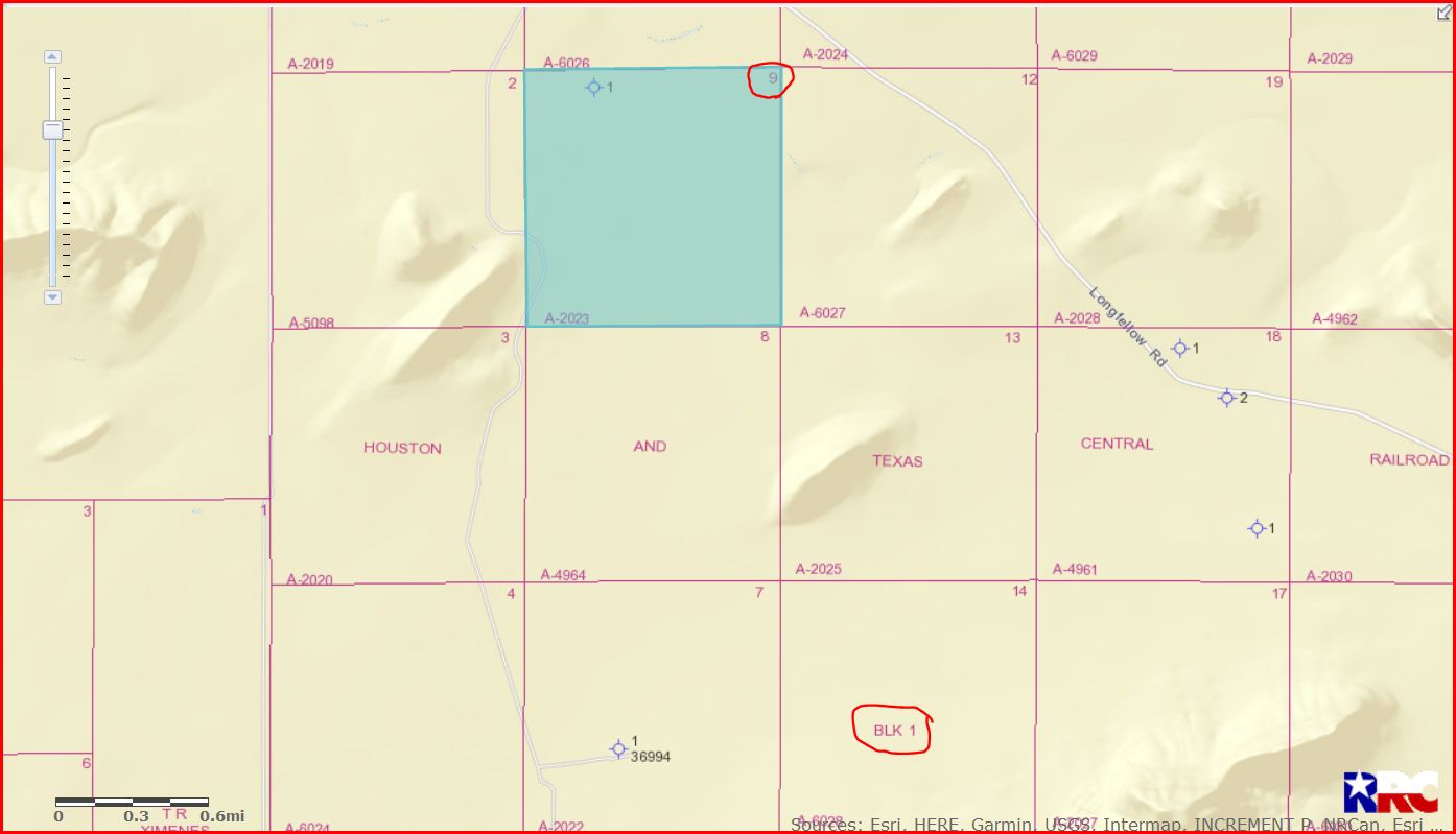
Daniel it’s easier for me to find property on the GLO map if I have the Abstract number. The Abstract number you are needing is A-2023. And all I see in Section 9 is a dry hole that was drilled years ago…no production in the area.
GIS map of Pecos County Section 9/Block 1/A-2023:
DOUBLE LEFT CLICK ON MAP TO ENLARGE
Clint Liles
---
### Author:  [@Daniel\_White1](https://www.mineralrightsforum.com/u/Daniel_White1)
#### Post date: [January 22, 2019, 2:49am UTC](https://www.mineralrightsforum.com/t/help-finding-blk-1-sec-9-pecos-cnty/40462/3 "2019-01-22T02:49:15Z")
Thanks. I will have to contact Chevron as a copy of the lease they sent, which dates to June 1994, indicates sections 7-8-9 of Block 1 are in a pooled unit of 699.7 acres and the property name is “Ft Stockton GU 6-2.” The well is old and production is close to zero. I received a royalty check for about $75 for slightly over 4 years of production. The issue is…I can’t find the location of the well. Not that it really matters, just curious. Thanks for pointing me in the right direction!
---
### Author:  [@Clint\_Liles](https://www.mineralrightsforum.com/u/Clint_Liles)
#### Post date: [January 22, 2019, 5:39am UTC](https://www.mineralrightsforum.com/t/help-finding-blk-1-sec-9-pecos-cnty/40462/4 "2019-01-22T05:39:07Z")
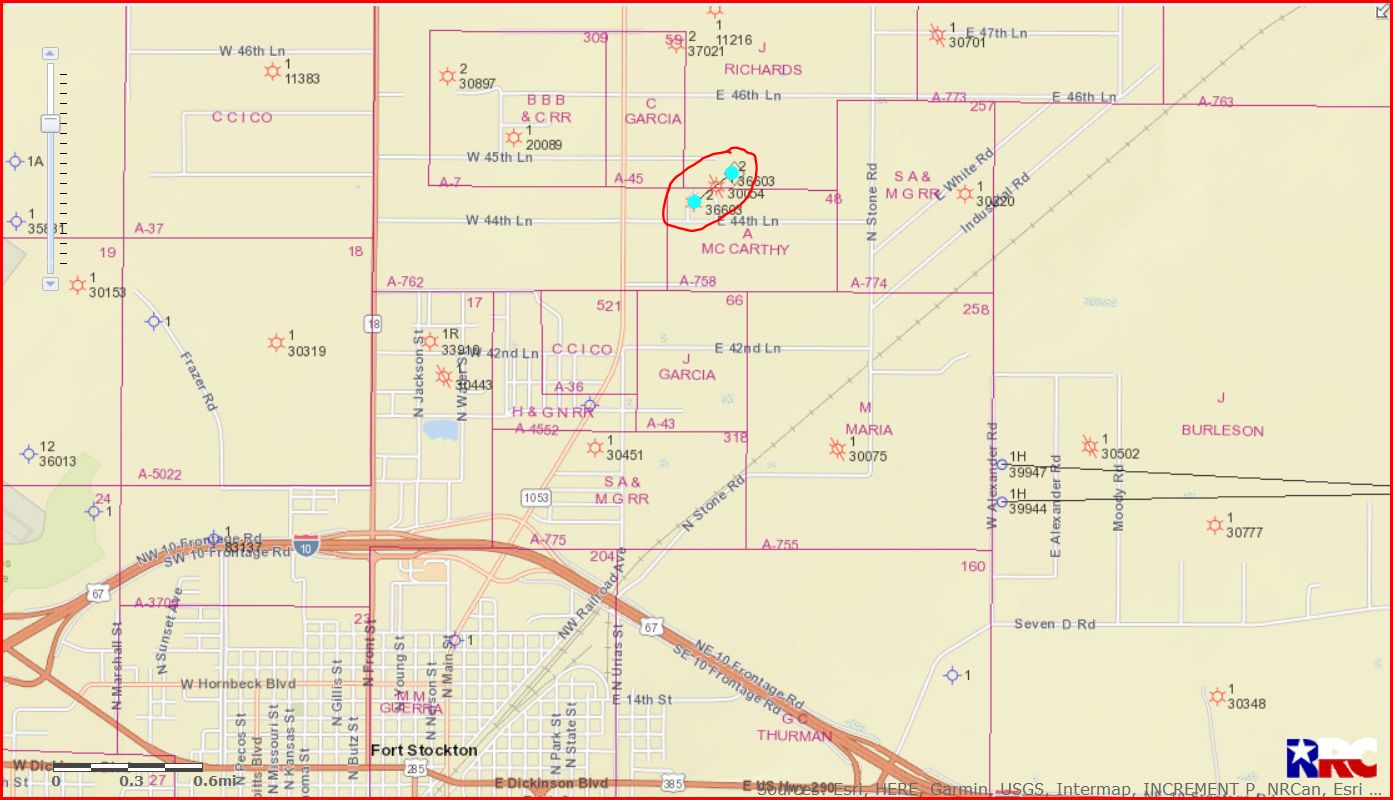
Daniel the operator of the well is Chevron Midcontinent/API 371-36603/Lease #168624. Link to production data on Ft. Stockton GU6 well #2:
[http://webapps2.rrc.texas.gov/EWA/specificLeaseQueryAction.do?tab=init&viewType=prodAndTotalDisp&methodToCall=fromGisViewer&pdqSearchArgs.paramValue=](http://webapps2.rrc.texas.gov/EWA/specificLeaseQueryAction.do?tab=init&viewType=prodAndTotalDisp&methodToCall=fromGisViewer&pdqSearchArgs.paramValue=%7C2=12%7C3=2017%7C4=11%7C5=2018%7C103=168624%7C6=G%7C102=08%7C8=specificlease%7C204=district%7C9=dispdetails%7C10=0)
Link to approved recompletion permit:
[http://webapps2.rrc.state.tx.us/EWA/drillingPermitDetailAction.do?methodToCall=searchByUniversalDocNo&universalDocNo=553822&rrcActionMan=H4sIAAAAAAAAAL1Qu27DMAz8mnQU9IjdLByMop37CJrByKDYhCNAtgxKRltAH1\_aRYHU6ZyNdzydjpeVlKCzkgrUHVFTNcmF4bWhtpZHWPgPPNlxjFrwWsRkE4r0Kaa4MdVOskLDRj89HioezTy25Lx3Q\_eM1LsUXyakrx9b0QYWbaHHdA7tPjxY75kogDBNNOzDG1pqzkztQF6lqeOyraiLYrRk-3frJ1xCcgZzr0xZSjOjAk7YuSEeXJrN2O0PVnqFL\_Wrb9XtSoi\_x5cw2g7p4sh\_G1HHeq2bw4LKGpTMBkzegswFEyUT169v0uc3jbokpGECAAA](http://webapps2.rrc.state.tx.us/EWA/drillingPermitDetailAction.do?methodToCall=searchByUniversalDocNo&universalDocNo=553822&rrcActionMan=H4sIAAAAAAAAAL1Qu27DMAz8mnQU9IjdLByMop37CJrByKDYhCNAtgxKRltAH1_aRYHU6ZyNdzydjpeVlKCzkgrUHVFTNcmF4bWhtpZHWPgPPNlxjFrwWsRkE4r0Kaa4MdVOskLDRj89HioezTy25Lx3Q_eM1LsUXyakrx9b0QYWbaHHdA7tPjxY75kogDBNNOzDG1pqzkztQF6lqeOyraiLYrRk-3frJ1xCcgZzr0xZSjOjAk7YuSEeXJrN2O0PVnqFL_Wrb9XtSoi_x5cw2g7p4sh_G1HHeq2bw4LKGpTMBkzegswFEyUT169v0uc3jbokpGECAAA)
GIS map of Pecos County Block 1 Section 9/circled in red is well 36603:
DOUBLE LEFT CLICK ON MAP TO ENLARGE
Clint Liles
---
### Author:  [@Daniel\_White1](https://www.mineralrightsforum.com/u/Daniel_White1)
#### Post date: [January 22, 2019, 3:29pm UTC](https://www.mineralrightsforum.com/t/help-finding-blk-1-sec-9-pecos-cnty/40462/5 "2019-01-22T15:29:45Z")
Great information…thanks! I will keep it bookmarked for future reference. The offers to purchase, so far nothing but bogus fishing expeditions, are starting to arrive again. I am now much more knowledgeable about my Pecos County property and can continue ignoring their calls and letters.
---
### Author:  [@MRFAdmin\_SV](https://www.mineralrightsforum.com/u/MRFAdmin_SV)
#### Post date: [January 11, 2025, 5:16pm UTC](https://www.mineralrightsforum.com/t/help-finding-blk-1-sec-9-pecos-cnty/40462/6 "2025-01-11T17:16:12Z")