# Grady 35-8-8
**URL:** https://www.mineralrightsforum.com/t/grady-35-8-8/86502
**Category:** General Mineral Rights Discussion
**Created:** [March 14, 2026, 9:51am UTC](https://www.mineralrightsforum.com/t/grady-35-8-8/86502 "2026-03-14T09:51:40Z")
**Posts on this page:** 9
**Page:** 1
### Author:  [@Mike\_Humphrey](https://www.mineralrightsforum.com/u/Mike_Humphrey)
#### Post date: [March 14, 2026, 9:51am UTC](https://www.mineralrightsforum.com/t/grady-35-8-8/86502/1 "2026-03-14T09:51:40Z")
Current drilling status in Grady County: 35-8-8? We received a lease bonus, but OCC Well Finder doesn’t seem to show status. Available info is for old plugged wells…
---
### Author:  [@M\_Barnes](https://www.mineralrightsforum.com/u/M_Barnes)
#### Post date: [March 14, 2026, 1:43pm UTC](https://www.mineralrightsforum.com/t/grady-35-8-8/86502/2 "2026-03-14T13:43:52Z")
There is a rig in 35-8N-8W, but it is sitting on the far southern eastern edge and drilling into 8N-7W. No OCC cases for 35-8N-8W in the last 24 months.
---
### Author:  [@Mike\_Humphrey](https://www.mineralrightsforum.com/u/Mike_Humphrey)
#### Post date: [March 14, 2026, 3:31pm UTC](https://www.mineralrightsforum.com/t/grady-35-8-8/86502/3 "2026-03-14T15:31:44Z")
Thank you Martha. 🙂 My brothers & I have been tracking since Continental drilled a Lowe well in 34-8-8, extending south down to the Southeast corner, near the Southwest corner of 35-8-8. The OCC map indicates irregular boundaries there: due to river tributaries/creeks there?
---
### Author:  [@M\_Barnes](https://www.mineralrightsforum.com/u/M_Barnes)
#### Post date: [March 14, 2026, 4:06pm UTC](https://www.mineralrightsforum.com/t/grady-35-8-8/86502/4 "2026-03-14T16:06:48Z")
Let me check again. The website I was using earlier today was not responding well. They usually do updates on Saturdays, so not all portions were functioning. The well portion was hiccuping.
---
### Author:  [@M\_Barnes](https://www.mineralrightsforum.com/u/M_Barnes)
#### Post date: [March 14, 2026, 4:15pm UTC](https://www.mineralrightsforum.com/t/grady-35-8-8/86502/5 "2026-03-14T16:15:18Z")
You are right, the corner of the section is a bit unusual due to the river. However, the final order of the Lowe well puts all of the production in section 27& 34.
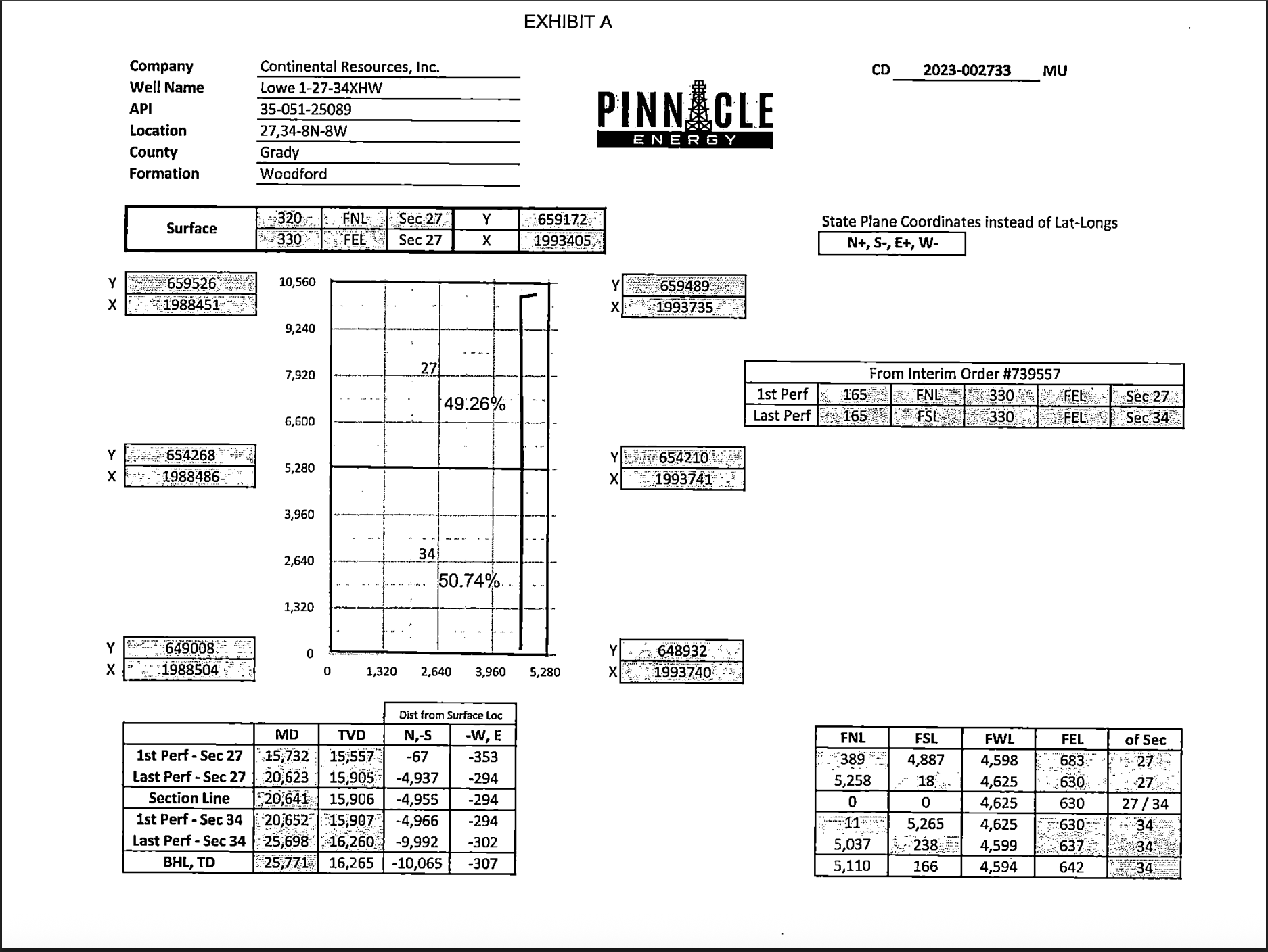
> **[0008ec10.pdf](https://di-diml-silver-prod.s3.amazonaws.com/b9tt9r1vik7g1ft00pkg/1374392/0008ec10.pdf?X-Amz-Algorithm=AWS4-HMAC-SHA256&X-Amz-Credential=AKIAITASBG5G6HSJAKIA%2F20260314%2Fus-east-1%2Fs3%2Faws4_request&X-Amz-Date=20260314T161305Z&X-Amz-Expires=54000&X-Amz-SignedHeaders=host&X-Amz-Signature=83b4d7bb0598882694705bb159a59af4696f699f224fa58173f256126e16a33b)**
---
### Author:  [@Mike\_Humphrey](https://www.mineralrightsforum.com/u/Mike_Humphrey)
#### Post date: [March 18, 2026, 7:53pm UTC](https://www.mineralrightsforum.com/t/grady-35-8-8/86502/6 "2026-03-18T19:53:54Z")
Martha, I still see no icon on OCC Well Finder indicating the drilling rig you mentioned. Should I look elsewhere?
The graphics programming has errors (empty icons) for some of the older, adjacent wells in Section 35, Township 8, Range 8.
---
### Author:  [@M\_Barnes](https://www.mineralrightsforum.com/u/M_Barnes)
#### Post date: [March 18, 2026, 8:26pm UTC](https://www.mineralrightsforum.com/t/grady-35-8-8/86502/7 "2026-03-18T20:26:48Z")
The OCC well finder is not particularly useful. I use a subscription service for rigs which is behind a paywall. The rig I mentioned is the Cactus 166 rig. It is drilling for Magnolia into sections 2 & 11 of 7N-8W, so no perforations in 35. If you want to look up the well, the API is 3505100421 and it has the surface location on form 1000 at the OCC well records site.
---
### Author:  [@Mike\_Humphrey](https://www.mineralrightsforum.com/u/Mike_Humphrey)
#### Post date: [March 18, 2026, 8:29pm UTC](https://www.mineralrightsforum.com/t/grady-35-8-8/86502/8 "2026-03-18T20:29:24Z")
Thanks, Martha! I’ll check it out…
---
### Author:  [@system](https://www.mineralrightsforum.com/u/system)
#### Post date: [June 12, 2026, 9:52am UTC](https://www.mineralrightsforum.com/t/grady-35-8-8/86502/9 "2026-06-12T09:52:22Z")
This topic was automatically closed after 90 days. New replies are no longer allowed.