# Flat Creek Resources LLC
**URL:** https://www.mineralrightsforum.com/t/flat-creek-resources-llc/55566
**Category:** General Mineral Rights Discussion
**Created:** [February 2, 2020, 11:46am UTC](https://www.mineralrightsforum.com/t/flat-creek-resources-llc/55566 "2020-02-02T11:46:39Z")
**Posts on this page:** 8
**Page:** 1
### Author:  [@ledp](https://www.mineralrightsforum.com/u/ledp)
#### Post date: [February 2, 2020, 11:46am UTC](https://www.mineralrightsforum.com/t/flat-creek-resources-llc/55566/1 "2020-02-02T11:46:39Z")
Does anyone know if the Flat Creek-Woods 2-H was ever frac’d? The oil sales on Woods 1-H are significantly higher volumes than 2-H. The two wells were originally operated by Arabella.
---
### Author:  [@TODD\_M\_Baker](https://www.mineralrightsforum.com/u/TODD_M_Baker)
#### Post date: [February 2, 2020, 2:57pm UTC](https://www.mineralrightsforum.com/t/flat-creek-resources-llc/55566/2 "2020-02-02T14:57:08Z")
Location would help get you an answer.
---
### Author:  [@ledp](https://www.mineralrightsforum.com/u/ledp)
#### Post date: [February 3, 2020, 4:32pm UTC](https://www.mineralrightsforum.com/t/flat-creek-resources-llc/55566/3 "2020-02-03T16:32:05Z")
Reeves County, Texas Block 51 Township 8S Section 12
---
### Author:  [@NMoilboy](https://www.mineralrightsforum.com/u/NMoilboy)
#### Post date: [February 5, 2020, 2:24pm UTC](https://www.mineralrightsforum.com/t/flat-creek-resources-llc/55566/4 "2020-02-05T14:24:21Z")
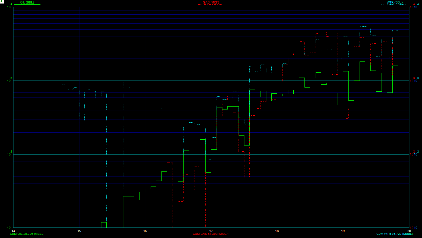
I don’t know. You would assume it was fracked. That would seem to be the whole point. I just glanced at the completion report, where they list a number of cement squeezes and say “not fracked” and suggest it may only be producing from the pre-perfed toe. So maybe not fracked due to mechanical issues. It’s not very often that a fracked well actually starts at zero and inclines over a long period.
If you gotta know for sure, call Flat Creek under some pretense and ask them.
---
### Author:  [@ledp](https://www.mineralrightsforum.com/u/ledp)
#### Post date: [April 1, 2020, 11:41am UTC](https://www.mineralrightsforum.com/t/flat-creek-resources-llc/55566/5 "2020-04-01T11:41:46Z")
I see the production curve. This pictorial semi-log production data is cumulative volumes through time. It really does not tell me oil, gas and water volumes as to past history. I appreciate your comments. Please let me know how I can upload, view production data. The curve you sent me happened to be pulled from the RRC website. Again thanks for the information.
---
### Author:  [@NMoilboy](https://www.mineralrightsforum.com/u/NMoilboy)
#### Post date: [April 22, 2020, 7:10pm UTC](https://www.mineralrightsforum.com/t/flat-creek-resources-llc/55566/6 "2020-04-22T19:10:34Z")
That curve is rate vs time. That is your volume history. It’s not from the RRC website. And yeah, it’s inclining for whatever reason so I get why you think it might be cumulative volumes.
You asked if it was fracked. No, doesn’t appear so. You can find production on RRC website but it’s only on a lease, not a well, basis.
---
### Author:  [@ledp](https://www.mineralrightsforum.com/u/ledp)
#### Post date: [April 23, 2020, 10:55am UTC](https://www.mineralrightsforum.com/t/flat-creek-resources-llc/55566/7 "2020-04-23T10:55:23Z")
The decline curve on the Woods #2-H operated by Flat Creek Resources is just volumes for this well. Do you happen to have access to the initial well Woods #1-H drilled and completed in this section ( Section 12, BLK 51-T8s) the Woods #1-H. If so I would appreciate if you could forward the decline curve to me.
I have worked somewhat the RRC commision web site, but does it happen to provide when a drilling permit is filled on mineral acreage that I own? I probably will to have to check every once in a while. Thanks
---
### Author:  [@system](https://www.mineralrightsforum.com/u/system)
#### Post date: [May 2, 2020, 11:46am UTC](https://www.mineralrightsforum.com/t/flat-creek-resources-llc/55566/8 "2020-05-02T11:46:42Z")
This topic was automatically closed after 90 days. New replies are no longer allowed.