# Drilling in Pecos County
**URL:** https://www.mineralrightsforum.com/t/drilling-in-pecos-county/54647
**Category:** Pecos County, TX
**Created:** [January 8, 2020, 5:53pm UTC](https://www.mineralrightsforum.com/t/drilling-in-pecos-county/54647 "2020-01-08T17:53:06Z")
**Posts on this page:** 10
**Page:** 1
### Author:  [@4556](https://www.mineralrightsforum.com/u/4556)
#### Post date: [January 8, 2020, 5:53pm UTC](https://www.mineralrightsforum.com/t/drilling-in-pecos-county/54647/1 "2020-01-08T17:53:06Z")
Drilling by Township.
---
### Author:  [@M\_Barnes](https://www.mineralrightsforum.com/u/M_Barnes)
#### Post date: [January 8, 2020, 6:02pm UTC](https://www.mineralrightsforum.com/t/drilling-in-pecos-county/54647/2 "2020-01-08T18:02:16Z")
Welcome to forum. Did you have a particular question? I moved your post over to Pecos County. You would have to give a location and a question to perhaps get an answer.
---
### Author:  [@NMoilboy](https://www.mineralrightsforum.com/u/NMoilboy)
#### Post date: [January 9, 2020, 1:26pm UTC](https://www.mineralrightsforum.com/t/drilling-in-pecos-county/54647/3 "2020-01-09T13:26:52Z")
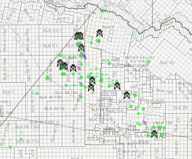
FWIW, here are wells drilled in the past 6 months (green) and current rig locations. Pretty much all Diamondback and Exxon.
---
### Author:  [@Joe\_R](https://www.mineralrightsforum.com/u/Joe_R)
#### Post date: [January 12, 2020, 6:22am UTC](https://www.mineralrightsforum.com/t/drilling-in-pecos-county/54647/4 "2020-01-12T06:22:41Z")
NMoilboy, where do you access these maps? And thanks for posting, as we have a few acres around the more active areas on this map.
---
### Author:  [@IcePilot](https://www.mineralrightsforum.com/u/IcePilot)
#### Post date: [January 12, 2020, 2:47pm UTC](https://www.mineralrightsforum.com/t/drilling-in-pecos-county/54647/5 "2020-01-12T14:47:36Z")
Source of map? Our land is a little farther East - Southeast.
---
### Author:  [@NMoilboy](https://www.mineralrightsforum.com/u/NMoilboy)
#### Post date: [January 13, 2020, 3:29pm UTC](https://www.mineralrightsforum.com/t/drilling-in-pecos-county/54647/6 "2020-01-13T15:29:20Z")
Hey Joe, that map is from DrillingInfo/Enverus, a subscription service.
---
### Author:  [@4556](https://www.mineralrightsforum.com/u/4556)
#### Post date: [January 16, 2020, 8:29pm UTC](https://www.mineralrightsforum.com/t/drilling-in-pecos-county/54647/7 "2020-01-16T20:29:39Z")
Is it correct to conclude from the map, that three wells were drilled in Section 1, Block 48, Township 8 in Pecos County, Texas? What is the significance of the green dot versus the green asterisk? Where can well production information be found? Thanks for your post!
---
### Author:  [@NMoilboy](https://www.mineralrightsforum.com/u/NMoilboy)
#### Post date: [January 16, 2020, 8:40pm UTC](https://www.mineralrightsforum.com/t/drilling-in-pecos-county/54647/8 "2020-01-16T20:40:49Z")
Honestly I’m not sure what the difference is between the asterisk and the dot.
There were two wells drilled in the Unit that makes up Section 1 and 12 of 48 8. There is an additional well permitted there that I don’t believe has spud. You can find production info on wells at the RRC website. These wells are the PRI operated Wahoo State wells.
I’m in a crunch now but can look all this up later.
---
### Author:  [@4556](https://www.mineralrightsforum.com/u/4556)
#### Post date: [January 16, 2020, 10:19pm UTC](https://www.mineralrightsforum.com/t/drilling-in-pecos-county/54647/9 "2020-01-16T22:19:20Z")
Thanks for the info.
---
### Author:  [@system](https://www.mineralrightsforum.com/u/system)
#### Post date: [March 8, 2020, 5:56pm UTC](https://www.mineralrightsforum.com/t/drilling-in-pecos-county/54647/10 "2020-03-08T17:56:48Z")
This topic was automatically closed after 60 days. New replies are no longer allowed.