# Drilling activity Reeves
**URL:** https://www.mineralrightsforum.com/t/drilling-activity-reeves/64315
**Category:** Reeves County, TX
**Created:** [December 25, 2021, 4:42pm UTC](https://www.mineralrightsforum.com/t/drilling-activity-reeves/64315 "2021-12-25T16:42:15Z")
**Posts on this page:** 7
**Page:** 1
### Author:  [@ledp](https://www.mineralrightsforum.com/u/ledp)
#### Post date: [December 25, 2021, 4:42pm UTC](https://www.mineralrightsforum.com/t/drilling-activity-reeves/64315/1 "2021-12-25T16:42:16Z")
any activity around Sections 12, 14 Block 51 T8S Reeves County?
---
### Author:  [@Mikro1TX](https://www.mineralrightsforum.com/u/Mikro1TX)
#### Post date: [December 25, 2021, 7:44pm UTC](https://www.mineralrightsforum.com/t/drilling-activity-reeves/64315/2 "2021-12-25T19:44:40Z")
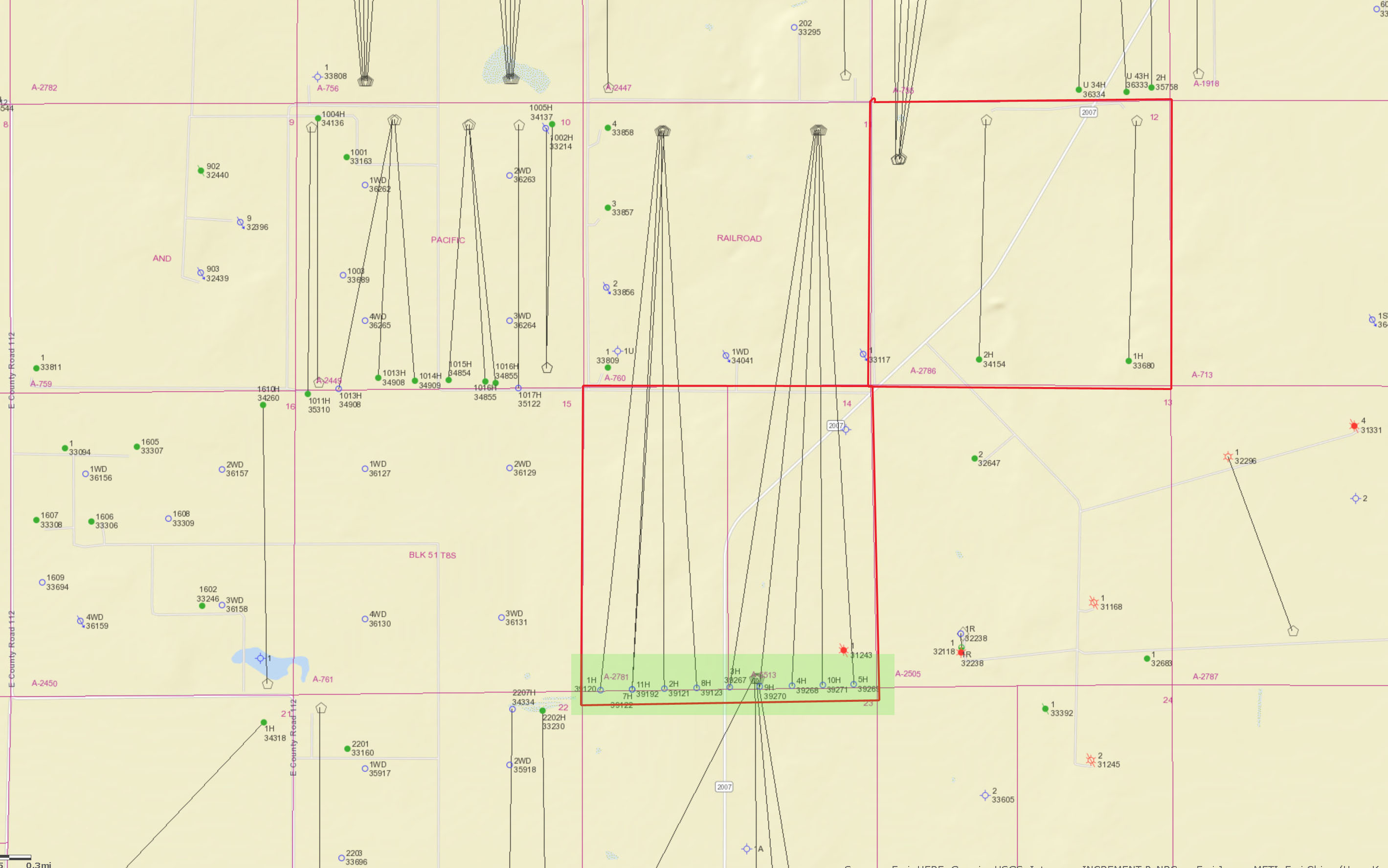
There appears to be a lot of activity in section 14. see the green shaded area in image. MK
---
### Author:  [@Clint\_Liles](https://www.mineralrightsforum.com/u/Clint_Liles)
#### Post date: [December 25, 2021, 9:23pm UTC](https://www.mineralrightsforum.com/t/drilling-activity-reeves/64315/3 "2021-12-25T21:23:21Z")
The RR Commission mapping system shows that Chevron USA has 10 approved permits for wells in Section 11 and ending in Section 14…those permits were approved in April and May 2021…but at this time I see no spud notification that drilling has begun. Permitted for 12,000’/Targeted formation is the Wolfbone(Trend Area) API numbers of these approved permits are 389-39120, 39121, 39122, 39123, 39267 ,39268, 39269, 39270, 39271 & 39192.
[http://webapps.rrc.texas.gov/DP/drillDownQueryAction.do?name=REV%2BBX%2BT8-51-11%2BH&fromPublicQuery=Y&univDocNo=494188595](http://webapps.rrc.texas.gov/DP/drillDownQueryAction.do?name=REV%2BBX%2BT8-51-11%2BH&fromPublicQuery=Y&univDocNo=494188595)
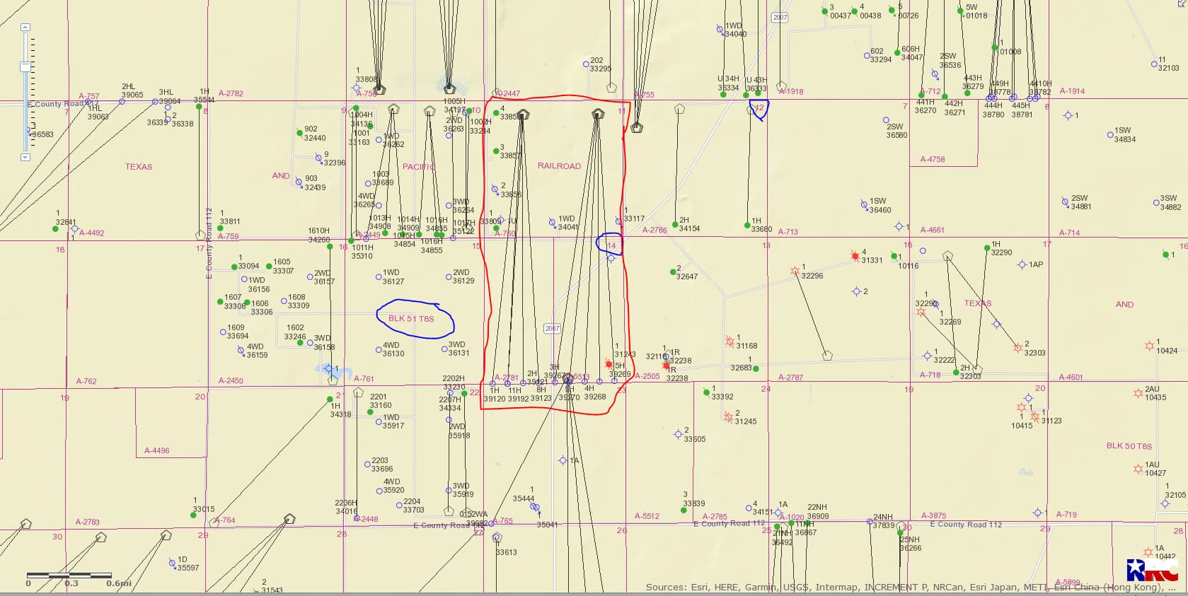
CLICK ON MAP TO ENLARGE
---
### Author:  [@william\_m\_blackburn](https://www.mineralrightsforum.com/u/william_m_blackburn)
#### Post date: [January 6, 2022, 6:56pm UTC](https://www.mineralrightsforum.com/t/drilling-activity-reeves/64315/4 "2022-01-06T18:56:06Z")
I have a NEMI in 678 acres, Section 11, Block 55, Township 10, Texas & Pacific Railway, in Reeves County, formerly leased by Apache Corp. Is this near the Chevron permitted sites and who is the party to contact there? Thanks.
---
### Author:  [@PeteR](https://www.mineralrightsforum.com/u/PeteR)
#### Post date: [January 6, 2022, 7:36pm UTC](https://www.mineralrightsforum.com/t/drilling-activity-reeves/64315/5 "2022-01-06T19:36:49Z")
William, your description is a little bit different than the one shown above. Your area is Block 55 and Township 10 South, Abstract 669, but the above is Block 51 and Township 8 South, Abstract 760. Abstract 669 is about 27 miles southwest from Abstract 760, and is south of I-10 and Abstract 760 is considerably north of I-10. Map of Abstract 669 shown below:

---
### Author:  [@william\_m\_blackburn](https://www.mineralrightsforum.com/u/william_m_blackburn)
#### Post date: [January 6, 2022, 7:42pm UTC](https://www.mineralrightsforum.com/t/drilling-activity-reeves/64315/6 "2022-01-06T19:42:58Z")
Thanks. No action apparently.
---
### Author:  [@system](https://www.mineralrightsforum.com/u/system)
#### Post date: [March 25, 2022, 4:42pm UTC](https://www.mineralrightsforum.com/t/drilling-activity-reeves/64315/7 "2022-03-25T16:42:27Z")
This topic was automatically closed after 90 days. New replies are no longer allowed.