# Does this mean four wells will be added to the pad?
**URL:** https://www.mineralrightsforum.com/t/does-this-mean-four-wells-will-be-added-to-the-pad/67444
**Category:** Mountrail County, ND
**Created:** [August 8, 2022, 10:09pm UTC](https://www.mineralrightsforum.com/t/does-this-mean-four-wells-will-be-added-to-the-pad/67444 "2022-08-08T22:09:13Z")
**Posts on this page:** 5
**Page:** 1
### Author:  [@mnsuper99](https://www.mineralrightsforum.com/u/mnsuper99)
#### Post date: [August 8, 2022, 10:09pm UTC](https://www.mineralrightsforum.com/t/does-this-mean-four-wells-will-be-added-to-the-pad/67444/1 "2022-08-08T22:09:14Z")
Hi!
I remain a novice at understanding public information on drilling activity. Does the following detail mean there will be four more wells added to the pad?
The detail is below, thanks in advance for your help!
#39077 - HESS BAKKEN INVESTMENTS II, LLC, RS-STATE D- 155-92-0203H-6, NE SE 2-155N-92W, Mountrail County, 1663’ FSL and 564’ FEL, DEVELOPMENT, ALGER, 2347’ GROUND, API – 33-061-05025
#39078 - HESS BAKKEN INVESTMENTS II, LLC, RS-STATE D- 155-92-0203H-7, NE SE 2-155N-92W, Mountrail County, 1630’ FSL and 564’ FEL, DEVELOPMENT, ALGER, 2349’ GROUND, API – 33-061-05026
#39079 - HESS BAKKEN INVESTMENTS II, LLC, RS-STATE D- 155-92-0203H-8, NE SE 2-155N-92W, Mountrail County, 1597’ FSL and 564’ FEL, DEVELOPMENT, ALGER, 2352’ GROUND, API – 33-061-05027
#39080 - HESS BAKKEN INVESTMENTS II, LLC, RS-STATE D- 155-92-0203H-9, NE SE 2-155N-92W, Mountrail County, 1564’ FSL and 564’ FEL, DEVELOPMENT, ALGER, 2356’ GROUND, API – 33-061-05028
---
### Author:  [@TODD\_M\_Baker](https://www.mineralrightsforum.com/u/TODD_M_Baker)
#### Post date: [August 9, 2022, 2:33am UTC](https://www.mineralrightsforum.com/t/does-this-mean-four-wells-will-be-added-to-the-pad/67444/2 "2022-08-09T02:33:17Z")
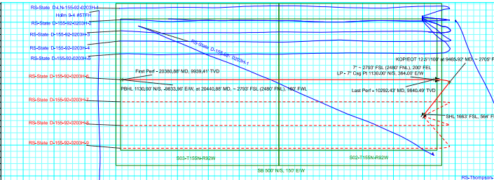
From that information only, yes. Hess plans to put four wells with surface locations 33’ apart. The projected bottom holes will be different.
---
### Author:  [@NMoilboy](https://www.mineralrightsforum.com/u/NMoilboy)
#### Post date: [August 9, 2022, 1:19pm UTC](https://www.mineralrightsforum.com/t/does-this-mean-four-wells-will-be-added-to-the-pad/67444/3 "2022-08-09T13:19:33Z")
It’s a new pad. Four red wellbore paths in the picture below. Added to the 1280-acre unit.
---
### Author:  [@mnsuper99](https://www.mineralrightsforum.com/u/mnsuper99)
#### Post date: [August 17, 2022, 4:55pm UTC](https://www.mineralrightsforum.com/t/does-this-mean-four-wells-will-be-added-to-the-pad/67444/4 "2022-08-17T16:55:11Z")
Thank you so much!
I only heard about these being drilled through word of mouth. Is there a way to know in advance when additional wells will be drilled on land where I have interests?
---
### Author:  [@system](https://www.mineralrightsforum.com/u/system)
#### Post date: [November 6, 2022, 10:09pm UTC](https://www.mineralrightsforum.com/t/does-this-mean-four-wells-will-be-added-to-the-pad/67444/5 "2022-11-06T22:09:57Z")
This topic was automatically closed after 90 days. New replies are no longer allowed.